
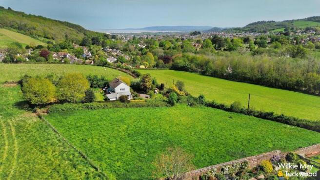
Bratton Lane, Minehead
- PROPERTY TYPE
Plot
- SIZE
Ask agent
Key features
- Sought after position on the outskirts of Minehead
- Planning permission in place for one detached dwellinghouse
- Wonderful views of the surrounding countryside
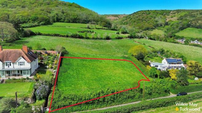
- Plot extending to 0.85 acres
- NO ONWARD CHAIN
Description
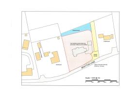
A piece of land extending to 3440.00 sq. meters (0.85 of an acre) adjacent to Dunboyne, Bratton Lane, Minehead with planning permission in place for the erection of 1 No. dwelling with detached double garage, means of access, landscaping and associate works under Application No. 3/21/25/023
AGENT’S NOTE: There will be an area of shared access as shown on the site plan to allow access to the land to the rear.
GENERAL REMARKS AND STIPULATION
Tenure: The land is offered for sale freehold by private treaty with vacant possession on completion.
Services: None
Local Authority: Somerset Council, Deane House, Belvedere Road, Taunton TA1 1HE
Flood Risk: Surface Water: Very low risk Rivers and the Sea: Very low risk Reservoirs: Unlikely Groundwater: Unlikely. We recommend you check the risks on Local planning information is available on
Brochures
Land on Bratton Lane Brochure.pdfBratton Lane, Minehead

NEAREST STATIONS
Distances are straight line measurements from the centre of the postcode- Llantwit Major Station14.0 miles


Notes
Disclaimer - Property reference 34727127. The information displayed about this property comprises a property advertisement. Rightmove.co.uk makes no warranty as to the accuracy or completeness of the advertisement or any linked or associated information, and Rightmove has no control over the content. This property advertisement does not constitute property particulars. The information is provided and maintained by Wilkie May & Tuckwood, Minehead. Please contact the selling agent or developer directly to obtain any information which may be available under the terms of The Energy Performance of Buildings (Certificates and Inspections) (England and Wales) Regulations 2007 or the Home Report if in relation to a residential property in Scotland.