

West Hoe Farm and Burwells Orchard, West Hoe Lane, Bishops Waltham, Southampton
- PROPERTY TYPE
Detached
- BEDROOMS
4
- BATHROOMS
3
- SIZE
3,098 sq ft
288 sq m
- TENUREDescribes how you own a property. There are different types of tenure - freehold, leasehold, and commonhold.Read more about tenure in our glossary page.
Freehold
Key features
- SEE AND PRINT PDF SALES PARTICULARS AVAILABLE BELOW
- SEE DRONE VIDEO FOOTAGE ON THE VIRTUAL TOUR TAB
- APPROX. 67.17 ACRES (27.19 HA) IN ALL
- AVAILABLE AS A WHOLE OR IN UP TO 5 LOTS
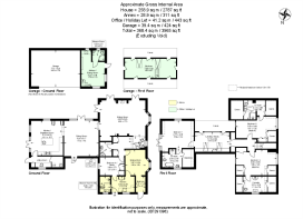
- 4 BEDROOM HOUSE WITH ANNEX (3,098 SQ. FT.)
- DETACHED GARAGE WITH OFFICE (443 SQ. FT.) – POTENTIAL HOLIDAY LET SUBJECT TO EXISTING APPLICATION
- 2 STEEL PORTAL FRAMED AGRICULTURAL BUILDINGS (TOTAL 6,072 SQ. FT.)
- UP TO APPROX. 42.34 ACRES ARABLE AND UP TO 16.89 ACRES PASTURE LAND
- POCKETS OF WOODLAND (4.11 ACRES)
- WITHIN SOUTH DOWNS NATIONAL PARK
Description
VIDEO DRONE FOOTAGE: See Selling Agent's website for further details, photographs, drone video footage is available showing the whole Property.
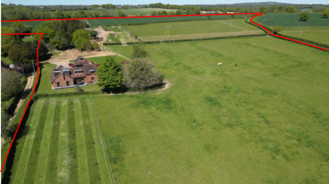
LOCATION: See Location Plan. The Property is positioned close to the eastern outskirts of the market town of Bishops Waltham, and close to the Village of Swanmore and the hamlet of Dundridge.
DIRECTIONS: Please see Location Plans 1 and 2 and use postcode or What3Words –
From Bishops Waltham: Head east from Bishops Waltham along Hoe Road towards Swanmore. From the roundabout at the northern end of Cricklemede in Bishops Waltham continue along Hoe Road towards Swanmore for approx. 1/3 mile and then turn left into West Hoe Lane immediately in front of a building and wall on left hand side of road. Continue for approx. 180 yards and then turn left (at Point A on the Site Plan) onto the gravel lane as shown dashed on the Site Plan, and the entrance to the house (Lot 1) is on the right after approx. 180 yards.
DESCRIPTION: West Hoe Farm and its house ‘Burwells Orchard’ extends in all to approx. 67.17 acres (27.19 Ha) as shown coloured on the Site Plan. The agricultural land has been within the Vendors’ family for over 120 years.
The house occupies a quiet and attractive position beside its pasture land and beside a quiet track, with southerly views from its slightly elevated position.
The house has a detached Garage and space used as an Office at both ground floor and first floor level (see Floor Plan). The Vendor has a Planning Application awaiting a decision for this space to be used as short term holiday accommodation (see Planning section below).
The range of modern steel framed buildings is well positioned away from the house and beside the arable land.
THE HOUSE: Known as Burwells Orchard and built in approx. 1950 provides up to 3,098ft2 (287m2) of accommodation with 3 bedrooms on the First Floor with En Suite facilities as shown on the Floor Plan, which includes an area currently used as a 1 bedroomed Annex (approx. 311ft2) by the Vendors as shaded yellow on the Floor Plan.
THE OFFICE AND GARAGE: A timber clad detached building adjoining the parking area a short distance from the house. Currently used as an open car-port storage space adjoining a purpose built office on the ground floor (197ft2) with toilet and kitchenette facilities, and with stairs leading to further accommodation (240ft2) at first floor level.
THE BUILDINGS: A useful pair of buildings providing modern storage and use. Located in Lot 4.
Northern Building: 45ft x 60ft (13.7m x 18.3m) 4 Bays. 2 integral stables.
Southern Building: 45ft x 75ft (13.7m x 22.9m) 5 Bays with additional chemical/workshop store. Part concrete floor.
Diesel Tank: 2,500 Litre Bunded.
The Property is available for sale either as a whole or in up to 5 Lots as identified on the Site Plan.
NB – The boundaries between the smaller Lots are predominantly utilising existing boundary features (hedges) – Lot 1 if sold alone then short sections of new fencing may then be required to slightly enlarge the surrounds of the house.
LOTS 2 AND 3 ARE NOT FOR SALE ALONE AND SO CAN ONLY BE PURCHASED IN COMBINATION WITH EITHER LOT 1 OR LOT 4.
THE ARABLE LAND: Approx. 42.34 acres (17.14 Ha) of land is currently cropped across Lots 4 and 5 with some grass margins or corners.
The block of reasonably level arable land is classified as Grade 3 on the Land Classification and the Geological Survey Plan identifies the soils to be freely draining lime-rich loamy soils. The land lies approximately 75m above sea level.
There is currently a crop of Winter Wheat growing on the land. The Cropping rotation in recent years:
Harvest 2025 – Oil Seed Harvest 2024 – Winter Barley Harvest 2023 – Winter Wheat
THE PASTURE LAND: Lots 2 and 3 are pasture land historically used for grazing of horses but cattle and sheep have grazed in the past. Water troughs serve this land and the boundaries are currently Stockproof. There is an area of pasture land (approx. 6.17 acres) at the northern end of Lot 5.
BYWAY: The Byway along and through the eastern edge of the farm, between positions C, D and E on the Site Plan provides access to both Lot 5 and to Dundridge to the north with quiet lanes and bridleways for equestrian hacking.
LAND REGISTRY: West Hoe Farm comprises the entirety of 3 Titles HP580747, HP592362 and HP565406 along with approx. 6.65 acres of pasture land (predominantly Lot 2) which is currently unregistered. See Selling Agent’s website for both Land Registry Title Plans and Registers.
PLANNING HISTORY: See below the applications affecting the Property.
Application in Progress and not yet decided – Submitted 15th July 2024 SDNP/24/02914/FUL change of use of farm office and garage loft space to holiday accommodation. Install ground mounted solar (PV) array in garden. Re-model north and east facing porches
April 2006 - 06/00610/FUL Two-storey rear extension; demolition of garage and replace with double detached garage with office attached
March 1979 - 79/00250/OLD Erection of extension to provide granny flat
March 1977 - 77/00217/OLD Erection of extension to lounge
PUBLIC RIGHTS OF WAY: There is a Public Footpath across the track and the arable land in Lot 4 as identified to the north of position B on the Site Plan.
SERVICES: Mains Water and Electricity. Ground Source Heat Pump. Partial Under Floor Heating. . Private Drainage (Septic Tank). Buildings - (3 Phase is not connected but available from nearby 11kv Transformer)
DESIGNATIONS: No environmental designations affect the Property.
WAYLEAVES: An overhead 11kv electricity line on wooden poles crosses the Property.
COUNCIL TAX:
Annex – Band A. Charges for 2026/2027 £1,644.47
House – Band E. Charges for 2026/2027 £3,014.87
BUSINESS RATES: None currently demanded.
LOCAL AUTHORITY: Winchester City Council (WCC), City Offices, Colebrook Street, Winchester SO23 9LJ.
PLANNING AUTHORITY: South Downs National Park Authority (SDNP), South Downs Centre, North Street, Midhurst, West Sussex GU29 9DH.
Brochures
Sales Particulars- COUNCIL TAXA payment made to your local authority in order to pay for local services like schools, libraries, and refuse collection. The amount you pay depends on the value of the property.Read more about council Tax in our glossary page.
- Band: E
- PARKINGDetails of how and where vehicles can be parked, and any associated costs.Read more about parking in our glossary page.
- Garage,Driveway,Off street,Private
- GARDENA property has access to an outdoor space, which could be private or shared.
- Front garden,Private garden,Patio,Rear garden,Back garden
- ACCESSIBILITYHow a property has been adapted to meet the needs of vulnerable or disabled individuals.Read more about accessibility in our glossary page.
- Ground floor
West Hoe Farm and Burwells Orchard, West Hoe Lane, Bishops Waltham, Southampton

Add an important place to see how long it'd take to get there from our property listings.
__mins driving to your place
Affordability
About Giles Wheeler-Bennett, Southampton
West Court, Lower Basingwell Street, Bishop's Waltham, SO32 1AJ
Get an instant, personalised result:
- Show sellers you’re serious
- Secure viewings faster with agents
- No impact on your credit score
Notes
Staying secure when looking for property
Ensure you're up to date with our latest advice on how to avoid fraud or scams when looking for property online.
Visit our security centre to find out moreDisclaimer - Property reference WestHoeFarmWhole. The information displayed about this property comprises a property advertisement. Rightmove.co.uk makes no warranty as to the accuracy or completeness of the advertisement or any linked or associated information, and Rightmove has no control over the content. This property advertisement does not constitute property particulars. The information is provided and maintained by Giles Wheeler-Bennett, Southampton. Please contact the selling agent or developer directly to obtain any information which may be available under the terms of The Energy Performance of Buildings (Certificates and Inspections) (England and Wales) Regulations 2007 or the Home Report if in relation to a residential property in Scotland.
*This is the average speed from the provider with the fastest broadband package available at this postcode. The average speed displayed is based on the download speeds of at least 50% of customers at peak time (8pm to 10pm). Fibre/cable services at the postcode are subject to availability and may differ between properties within a postcode. Speeds can be affected by a range of technical and environmental factors. The speed at the property may be lower than that listed above. You can check the estimated speed and confirm availability to a property prior to purchasing on the broadband provider's website. Providers may increase charges. The information is provided and maintained by Decision Technologies Limited. **This is indicative only and based on a 2-person household with multiple devices and simultaneous usage. Broadband performance is affected by multiple factors including number of occupants and devices, simultaneous usage, router range etc. For more information speak to your broadband provider.