

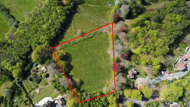
Scotland Lane, Haslemere, Surrey
- PROPERTY TYPE
Plot
- SIZE
4,230 sq ft
393 sq m

Description
Full details of the planning approval can be reviewed via the council’s web site (under planning reference WA/2025/02165)
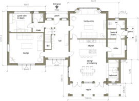
Accommodation: The permission affords:
5 bedrooms, 4 bathrooms, reception hallway, living room, kitchen dining/entertainment room, family room, utility room, boot room, cloakroom. Triple garage with studio over.
Location
The property is situated in a favoured residential road on the southern edge of Haslemere about ½ mile from Haslemere High Street with the wider town offering a variety of independent and national traders to include Waitrose, Marks and Spencer (food hall) and Tesco supermarkets, together with main line train station connecting London Waterloo in under 1 hour. The town benefits from a leisure centre and at Woolmer Hill there are sports facilities (rugby and hockey), together with tennis, football and cricket at the Recreation directly opposite the site. The main A3 dual carriageway at Hindhead offers good road connections with the main airports of Gatwick and Heathrow, approximately 48 miles and 38 miles respectively, with access to the M25 at Junction 10 (22 miles). Portsmouth is 32 miles to the south offering easy connectivity to the South Coast. Footpath links connect the site with Blackdown National Trust and the wider South Downs National Park to the south, with nearby Hindhead providing further extensive walking and countryside pursuits at Hindhead Common and the ‘Devils Punchbowl’ beauty spot. Golf is readily available at Hindhead, Liphook, Cowdray Park and Chiddingfold; horse racing at Goodwood and Fontwell; motor racing at Goodwood (Festival of Speed and Goodwood Revival); polo at Cowdray Park and sailing on Frensham Ponds and off the south coast at Chichester. The general area offers a wide range of state primary and secondary schools together with a good selection of independent schools including Woolmer Hill, Haslemere (co-ed state secondary), St Ives, Haslemere (girls prep school), Seaford College, Petworth (co-ed public school), Charterhouse, Godalming (co-ed public school) Prior’s Field, Godalming (girls public school), St Edmund’s, Hindhead (co-ed prep school), Amesbury, Hindhead (co-ed prep school), Highfield and Brookham Schools, Liphook (co-ed prep school), Bohunt, Liphook (co-ed state school), Bedales, Petersfield (co-ed public school), The Petersfield School (co-ed state school), Edgeborough, Farnham (co-ed prep), Frensham Heights, Farnham (co-ed 3-18 yrs).
COMMUNITY INFRASTRUCTURE LEVY - assessed currently at £285,686.74. Self builders may qualify for exemption, subject to approvals
AML (Anti Money Laundering) - Estate agents operating in the UK are required to conduct Anti-Money Laundering (AML) checks in compliance with the regulations set forth by HM Revenue and Customs (HMRC) for all property transactions. It is mandatory for both buyers and sellers to successfully complete these checks before any property transaction can proceed. We use a company Coadjute to facilitate these checks. A non returnable fee will be charged for each individual AML check conducted.
Brochures
BrochureScotland Lane, Haslemere, Surrey

NEAREST STATIONS
Distances are straight line measurements from the centre of the postcode- Haslemere Station0.7 miles
- Liphook Station4.0 miles
- Witley Station4.5 miles
About Peter Leete & Partners, Grayshott
The Green Headley Road, Grayshott, Hindhead, GU26 6LG


Notes
Disclaimer - Property reference Scotland Lane building plot. The information displayed about this property comprises a property advertisement. Rightmove.co.uk makes no warranty as to the accuracy or completeness of the advertisement or any linked or associated information, and Rightmove has no control over the content. This property advertisement does not constitute property particulars. The information is provided and maintained by Peter Leete & Partners, Grayshott. Please contact the selling agent or developer directly to obtain any information which may be available under the terms of The Energy Performance of Buildings (Certificates and Inspections) (England and Wales) Regulations 2007 or the Home Report if in relation to a residential property in Scotland.