Residential Development Land, North Of Turnpike Road, Swindon, SN26
- SIZE AVAILABLE
541,451 sq ft
50,302 sq m
- SECTOR
Commercial development to lease
Lease details
- Lease available date:
- Ask agent
Key features
- Resolution to grant outline planning approval for the construction of up to 125 no. dwellings
- For sale by informal tender
- Offers to be received prior to Noon on Wednesday 12th August 2026
Description
For sale by informal tender
Offers to be received prior to Noon on Wednesday 12th August 2026
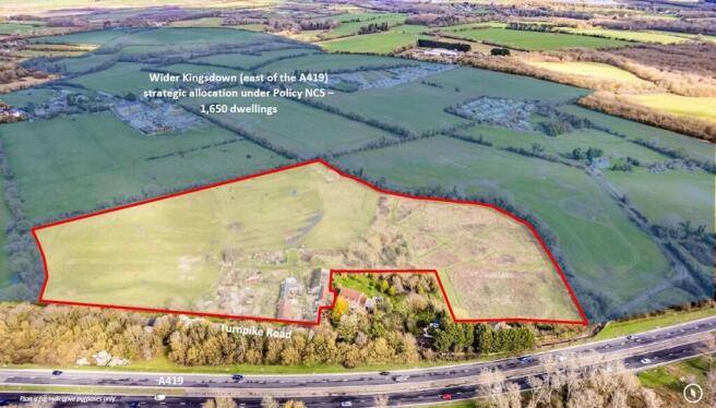
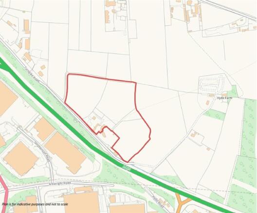
The site is located within Kingsdown (east of the A419) strategic allocation under Policy NC5 of the Swindon Borough Local Plan (2015). The site lies immediately north of Turnpike Road, with the A419 situated beyond a woodland buffer to the south. The surrounding area includes a mix of residential, agricultural and commercial uses.
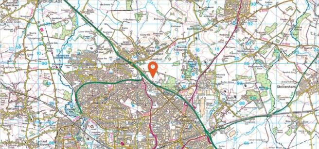
The site is approximately 1.4km from Broad Blunsdon, 3.9km from Swindon town centre, and 4km from Swindon railway station, which provides regional connectivity. Public transport is available via bus routes, with the nearest stop at the Turnpike Road & B4019 junction.
The site extends to approximately 12.43 acres (5.03 ha) and comprises a single parcel of agricultural land and paddocks, with a small number of buildings and an open storage area located near the south-western boundary. The boundaries are defined by Turnpike Road and a residential property to the south-west, and by hedgerows to the north, east and west. There are two access points from Turnpike Road, through existing agricultural gates. A public right of way crosses the site from the southwest to the north, connecting to Kingsdown Lane.
Please see the utilities quotes and plans supplied in the data room.
The subject site is located within the planning jurisdiction of Swindon Borough Council. Planning Policy is currently covered by
the Swindon Local Plan 2026, which was adopted in March 2015.
The site's pertinent planning history is outlined below:
- S/OUT/23/1443 - Outline Application for the construction of up to 125 residential dwellings and new access onto Turnpike Road; and associated road / footway / cycleway provision, open space, landscaping, surface water attenuation and ancillary works.
- S/OUT/20/0769 - Outline application for the erection of up to 125 no. dwellings and associated works - Access not reserved. *
*At Planning Committee on the 9th of September 2025, it was resolved that planning permission be granted for application S/OUT/20/0769 subject to the recommendations and conditions set out in the Case Officer's report, which included the completion of a S.106.
The Proposed Scheme
The approved scheme proposes a residential development of up to 125 no. dwellings, with all matters reserved except for access. The illustrative layout demonstrates how 125 no. units can be accommodated on site, including the demolition of existing and shows an indicative mix of dwelling types at an average density of 40 dwellings per hectare, across a developable area of c.7.68 acres.
The proposed vehicular access indicates that the proposed development would be accessed from a new entrance off Turnpike Road. The Plan also indicates pedestrian/cycle connections and vehicular access to the wider Kingsdown allocation area from the north of the site.
Highway Works
Hallam Land is currently in advance negotiations with three other nearby developments sites regarding a cost sharing arrangement for the Coldharbour and Lady Lane highways works (Scheme A & B in the Committee Report). Further details will be provided in due course, however bidders are requested to specifically list the cost allowance they have made for these works.
The site is offered for sale by way of informal tender. Offers are invited on an unconditional basis. Offers should be submitted in accordance with the 'Financial Proposal Form' contained within the Data Room and be received by Bruton Knowles prior to Noon on Wednesday 12th August 2026.
Offers should be sent via email to Harry Breakwell:
harry.
The purchaser is to provide an undertaking of £15,000 + VAT towards the vendor's abortive legal fees. The site is registered under the Freehold Titles WT224777 and WT435493.
Viewing of the site is by appointment only with Bruton Knowles.
Brochures
Residential Development Land, North Of Turnpike Road, Swindon, SN26

NEAREST STATIONS
Distances are straight line measurements from the centre of the postcode- Swindon Station2.4 miles
Notes
Disclaimer - Property reference 12435LH. The information displayed about this property comprises a property advertisement. Rightmove.co.uk makes no warranty as to the accuracy or completeness of the advertisement or any linked or associated information, and Rightmove has no control over the content. This property advertisement does not constitute property particulars. The information is provided and maintained by Bruton Knowles, Gloucester. Please contact the selling agent or developer directly to obtain any information which may be available under the terms of The Energy Performance of Buildings (Certificates and Inspections) (England and Wales) Regulations 2007 or the Home Report if in relation to a residential property in Scotland.
Map data ©OpenStreetMap contributors.