

Land to the west of Lordship Farm, Holwell
- PROPERTY TYPE
Land
- SIZE
1,098,583 sq ft
102,062 sq m
Description
FOR SALE AS A WHOLE
Introduction - An excellent opportunity to acquire an attractive block of arable land conveniently located on the western edge of the village of Holwell, near Hitchin. The land offers prospective purchasers scope for a range of uses including; agricultural, amenity, equestrian or environmental purposes, subject to the necessary consents
The land is offered for sale with vacant possession on completion.
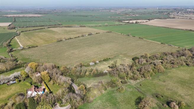
Location - The land lies approximately 4 miles north east of the market town of Hitchin and 6 miles east of Letchworth Garden City. The property benefits from road frontage onto Holwell Road and located in close proximity to the A600, A505, providing convenient connections to the surrounding area and wider road network.
Method Of Sale - The land is offered for sale by private treaty as a whole
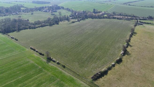
Description - The property extends to approximately 25.22 acres (10.21 hectares) of arable land, presented in a single, well-defined block on the edge of the village of Holwell. The land benefits from direct access off the public highway via a gated vehicular entrance over a culvert, with frontage to Holwell Road. The land parcel is regular in shape and gently rises towards the northern boundary.
The boundaries are well established, comprising a combination of ditches, mature trees and post and wire fencing. The land is currently entered into a Countryside Stewardship Scheme under option AB15 and has been drilled with a grass and clover mix.
According to Natural England’s Agricultural Land Classification, the land is predominantly Grade 3, with an area of Grade 2 located towards the northern part. Environment Agency flood mapping indicates the majority of the land lies within Flood Zone 1, with more limited areas along Holwell Road and the eastern boundary identified as Flood Zone 3.
The property falls within the administrative area of Central Bedfordshire Council and is subject to the policies of the Central Bedfordshire Local Plan, adopted July 2021.
Tenure And Possession - The land is offered for sale with vacant possession on completion.
Drainage Rates - Environment Agency drainage rates are currently payable at the standard rates
Vat - The land is not registered for VAT however if the sale of the property or any right attached to it is deemed a chargeable supply for the purpose of VAT, such tax shall be payable by the purchaser in addition to the sale price.
Town And Country Planning - The land is within Central Bedfordshire Council and all of the land lies outside of the development boundaries of Great Sampford. The land is sold subject to any development plans, tree preservation orders, town planning schedules, applications, permissions and resolutions which may be or come into force. The purchaser(s) will be deemed to have full knowledge and have satisfied themselves as to the provisions of any such matters affecting the property.
Basic Payment Scheme - The current owners have historically claimed for Basic Payment Scheme entitlements and the seller will retain any historic delinked payments.
Environmental And Grant Schemes - The land is currently entered into a 5-year middle tier Countryside Stewardship Scheme which terminates in December 2026. The land is not entered into a Sustainable Farming Incentive or any other schemes.
Sporting, Timber And Minerals - All sporting, timber and mineral rights are included in the sale insofar as they are owned.
Wayleaves, Easements, Covenants And Rights Of Way - The land is sold subject to and with the benefit of all existing wayleaves, easements, covenants and rights of way whether or not disclosed.
Tenant Right And Dilapidations - There will be no ingoing valuation, and the purchaser shall not claim for dilapidations, if any, in relation to the property.
Exchange And Completion - Exchange of contracts shall be within 6 weeks of the purchaser(s) solicitor receiving a draft contract. Completion will be by agreement between the parties.
Boundaries - The vendor and vendor’s agents will do their best to specify the ownership of boundary hedges, tree belts and ditches but will not be bound to determine these. The property is available for inspection and the purchaser(s) will be deemed to have satisfied themselves as to the ownership and location of the boundaries.
Plans, Areas And Schedules - Plans attached to the particulars are based upon the Ordnance Survey and are for identification purposes only.
Local Authority - Central Bedfordshire Council, Priory House, Monks Walk, Shefford, SG17 5TQ
Contact details can be found in the brochure.
Viewings And Further Information - The land can be viewed by prior arrangement with the Sole Agents. For further information please contact Jonathan Purkiss or Henry Lankfer on .
As always, potential hazards exist on working farms and it is requested that all viewings are undertaken with care and regard to safety.
Nearest Postcode: SG5 3QZ
what3words: ///buying.panels.jacket
Anti-Money Laundering Regulations - Buyers will be required to provide proof of identity and address to the Selling Agent following acceptance of an offer (subject to contract) and prior to Solicitors being instructed.
Sellers Solicitor - Horsey Lightly Solicitors, 2 West Mills, Newbury, Berkshire, RG14 5HG
Agents' Notes - For clarification we wish to inform purchaser(s) that we have prepared these sales particulars as a general guide. None of the statements contained in these particulars as to the property shall be relied on as statements of fact. All measurements are given as a guide and no liability can be accepted for errors arising therefrom. The plan and acreages use gross acreages taken from the Ordnance Survey sheets and are for identification purposes only. The purchaser(s) shall be deemed to have full knowledge of the state and condition thereof and as to the ownership of any tree boundary or any part of the property. If communications, condition of the property, situation or such factors are of particular importance to you please discuss these priorities with us before arranging an appointment to view. This should avoid a wasted journey. June 2026.
Brochures
96120 Cheffins_Land at Lordship Farm.pdfLand to the west of Lordship Farm, Holwell

NEAREST STATIONS
Distances are straight line measurements from the centre of the postcode- Hitchin Station2.9 miles
- Arlesey Station3.6 miles
- Letchworth Station3.6 miles

About Cheffins Residential, Agricultural and Land
1-2 Clifton Road, Cambridge, CB1 7EA


Notes
Disclaimer - Property reference 34743721. The information displayed about this property comprises a property advertisement. Rightmove.co.uk makes no warranty as to the accuracy or completeness of the advertisement or any linked or associated information, and Rightmove has no control over the content. This property advertisement does not constitute property particulars. The information is provided and maintained by Cheffins Residential, Agricultural and Land. Please contact the selling agent or developer directly to obtain any information which may be available under the terms of The Energy Performance of Buildings (Certificates and Inspections) (England and Wales) Regulations 2007 or the Home Report if in relation to a residential property in Scotland.
Map data ©OpenStreetMap contributors.