

Wrench Green, Hackness, Scarborough, North Yorkshire, YO13
- PROPERTY TYPE
Farm Land
- SIZE
Ask agent
Description
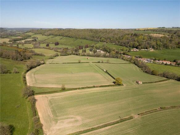
Lot 3 comprises a partially equipped ring-fenced parcel of productive agricultural land extending to approximately 183.94 acres (74.45 hectares).
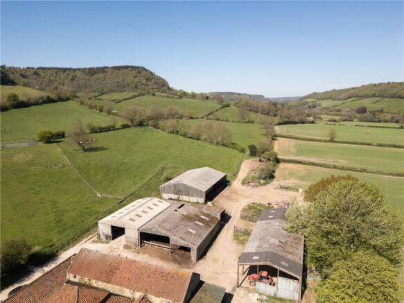
The modern buildings comprise a versatile range of steel and concrete portal framed structures providing grain storage, livestock accommodation and workshop/machinery storage.
The farm buildings included with Lot 3 more specifically comprise:
3. 7-bay Dutch barn of steel portal frame construction under a corrugated profile clad roof with earth floor (379 m²)
4. General purpose building of steel portal frame under corrugated profile clad roof with concrete block walls and corrugated profile clad to eaves with concrete floor (247 m²).
5. Livestock accommodation comprising concrete portal frame under corrugated profile clad roof and part concrete block walls with Yorkshire boarding to eaves (290 m²).
6. Lean-to of portal frame construction under a corrugated profile clad roof (159 m²).
7. Livestock accommodation comprising steel portal frame under corrugated profile clad roof and part concrete block walls with Yorkshire boarding to eaves with open feed barrier to north-eastern elevation (491 m²).
The land comprises arable land extending to approximately 40.54 acres (16.41 hectares), improved grassland extending to 47.91 acres (19.38 hectares), pasture land extending to 65.28 acres (26.45 hectares), woodland extending to 28.62 acres (11.57 hectares) with the farmstead extending to approximately 1.59 acres (0.64 hectares).
The land is classified as being Grade 6 under the former MAFF land classification with the underlying soil type being summarised as being part of the Wharfe series being a deep stoneless permeable fine loamy soil summarised as being suitable for cereals and permanent grassland.
The land is bound predominantly by mature hedgerow interspersed with timber post and wire fencing which provide stockproof boundaries.
The land has an easterly aspect rising from approximately 60 metres above sea level on the eastern boundary to 180 metres above sea level on the western boundary.
An access track leads from the farmstead and provides good access provisions to the arable land and improved grassland beyond whilst the public highway known as Lang Gate bounds the southern boundary which provides access to the land situated to the west of the farmstead.
Method of Sale
The property is offered for sale by private treaty. The vendors reserve the right to conclude the sale by any other means at their discretion.
Lot 3 forms part of the wider sale of Wrench Green Farm.
If you have downloaded these particulars, please register your interest with the selling agent.
Tenure & Possession
Lot 3 is let by virtue of a Farm Business Tenancy (FBT) which expires on 30th September 2026.
Basic Payment Scheme
The land has been registered on the Rural Land Register and all de-linked payments will be retained by the vendor.
Environmental Schemes
The land is currently entered into a Countryside Stewardship (Middle Tier) Agreement. Further details are available from the selling agent.
Ingoing Valuation and Holdover
In the event that the sale completes after the 2026 harvest, the purchaser(s) will be obliged to take over and pay for all growing crops, including cultivations, seeds, fertilisers, sprays, lime, new leys and acts of husbandry at cost or market value (whichever is higher) where applicable.
Designations
With the exception of Lot 4, the farm is situated within a Nitrate Vulnerable Zone (NVZ).
Additional Information
An additional information pack is available from the selling agents.
Wayleaves Easements & Rights of Way
The land is sold subject to and with the benefits of all rights of way, water drainage, water courses and other easements quasi or reputed easements and rights of adjoining owners (if any) affecting the same and all existing and proposed wayleaves and other matters registered by any competent authority subject to statute.
• A public footpath follows the riverbank of the river Derwent.
• A public footpath follows the access track of Coomb Slack Farm and continues north before branching west through Wood House Plantation.
• In the event that Lot 2 is sold in isolation, a private right of way will be granted through the farmyard to provide access rights to the northern elevation of the buildings.
Restrictive Covenants
Wrench Green Farm is sold subject to various restrictive covenants that were imposed upon
the title by the Hackness Estate when the property was purchased by the Vendors and include (but are not limited to):
• Not to use the property for any other purpose than a farm in pursuit of agriculture.
• Not to use the outbuildings for any purpose other than as farm buildings.
• Not to erect any new building without the approval of the Hackness Estate.
Further details are available from the selling agent.
Health & Safety
Please take care when viewing the property and be as vigilant as possible when making an inspection for your own personal safety.
VAT
Any prices quoted are exclusive of VAT. Should the property, any part of it or right attached become chargeable supply for VAT, such tax will be payable in addition to the purchase price.
Sporting Rights
The sporting rights are reserved to a third party and are excluded from the sale.
Mineral Rights
The mineral rights are included in the sale subject to a leasehold interest (due to expire September 2086) of the mines and minerals comprising evaporites including potash, polyhalite, salt and intermingled minerals lying below a depth of 800m from the surface.
Fishing Rights
The fishing rights are reserved to a third party and are excluded from the sale.
Local Authorities
North Yorkshire Council
North York Moors National Park
Viewings
Viewings are strictly by appointment only through the selling agent.
Directions
From the A170: on entering the village of East Ayton, opposite the Shell Filling Station, turn onto Castlegate (signposted Forge Valley, Hackness). Proceed for approximately 2 miles and continue as the road bears left and becomes Mowthorp Road. Continue for a further 1.5 miles and turn left signposted Wrench Green. Continue over the bridge that crosses the River Derwent and turn right at the T Junction onto Lang Gate and then turn left into the hamlet of Wrench Green. The farmhouse is situated at the end of the track.
Postcode: YO13 9AB
What3Words
///nooks.reform.reply
Brochures
ParticularsWrench Green, Hackness, Scarborough, North Yorkshire, YO13

NEAREST STATIONS
Distances are straight line measurements from the centre of the postcode- Scarborough Station4.6 miles
- Seamer Station5.4 miles

Notes
Disclaimer - Property reference HGT260032. The information displayed about this property comprises a property advertisement. Rightmove.co.uk makes no warranty as to the accuracy or completeness of the advertisement or any linked or associated information, and Rightmove has no control over the content. This property advertisement does not constitute property particulars. The information is provided and maintained by Carter Jonas Rural, Yorkshire. Please contact the selling agent or developer directly to obtain any information which may be available under the terms of The Energy Performance of Buildings (Certificates and Inspections) (England and Wales) Regulations 2007 or the Home Report if in relation to a residential property in Scotland.