

Whitestaunton, Chard, Somerset
- PROPERTY TYPE
Land
- SIZE
1,854,349 sq ft
172,275 sq m
Key features
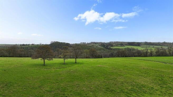
- An adaptable block of gently sloping pasture land , divided into three main enclosures.
- Suitable for mowing or grazing
- Range of farm buildings set around hardcore yards
- Hard tracks provide good access to the buildings and all fields.
- Excellent youngstock unit or small start up farm .
- In all 42.57 acres (17.24 ha.)
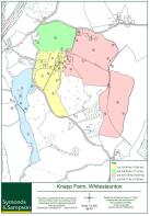
- Knapp Farm Lot Three - for Sale by private treaty as a whole or in up to four lots
Description
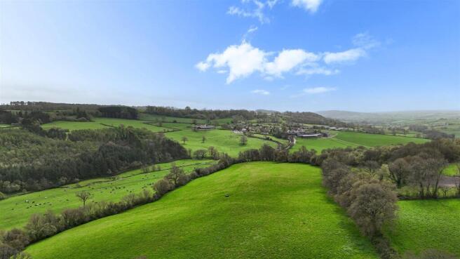
Situation - Knapp Farm occupies a secluded but accessible position in the heart of the Blackdown Hills National Landscape (AONB). The small village of Marsh is less than a mile away and has access to the A303 providing excellent links to London and Exeter. The market towns of Honiton and Chard (9 and 5 miles respectively), which cater for daily needs, including shops, schools and recreational facilities. Honiton has a mainline rail link to London Waterloo (2 hours 50 minutes). Taunton the county town of Somerset (12 miles) offers excellent retail, commercial and educational opportunities. Equestrian facilities at Chard Equestrian Centre & Bicton Park are within easy reach.
The Property - Knapp Farm comes to the open market for the first time since 1928 and was formerly part of the Whitestaunton Estate. It was a dairy farm until the late 1980’s and in recent years has been a beef unit.
Lot Three 42.14 Acres Of Pastureland With A Range - A useful and adaptable block of gently sloping pasture, accommodation land suitable for mowing or grazing, divided into three main enclosures. Hard tracks provide good access to the buildings and all fields. The range of farm buildings are set around hardcore yards include: Located close to the lane: Steel framed Dutch Barn with GI cladding with two Lean-to’s (18.53m x 12.65m). In the upper yard nearer the main farmstead: Steel frame Cattle Building (14.01m x 20.05m) with block and Yorkshire boarding and adjoining steel framed Cattle Building (24.41m x 20.05m) with block and GI cladding. This lot would make an excellent youngstock unit for a local farmer or could become a small start up farm for a new entrant. In all 42.57 acres (17.24 ha.)
Services - Lot Three: Private water available, not connected.
Tenure - Freehold with vacant possession upon completion.
Rights Of Way - A public bridleway crosses Lot Three, a good distance from the farmstead.
Designations - Knapp Farm is located in the Blackdown Hills National Landscape. The land is not situated within a Nitrate Vulnerable Zone (NVZ).
Agricultural Schemes - The farm is currently not in any subsidy schemes.
Fencing Obligations - If sold in lots, fencing obligations will become the purchaser’s responsibility, with any shared boundaries being 50/50.
Sporting - All rights are understood to be owned and included in the sale. Racing at Exeter or
Taunton. Golf at Cricket St Thomas or Taunton and Pickeridge. Sailing on the coast at
Seaton or Lyme Regis.
Dispersal Sale - The vendors reserve the right to hold a dispersal sale on the property prior to completion.
Local Authority - Somerset District Council Tel:
Brochures
Knapp Farm Final.pdfEnergy Performance Certificates
EE RatingWhitestaunton, Chard, Somerset

NEAREST STATIONS
Distances are straight line measurements from the centre of the postcode- Axminster Station8.1 miles


Notes
Disclaimer - Property reference 34751789. The information displayed about this property comprises a property advertisement. Rightmove.co.uk makes no warranty as to the accuracy or completeness of the advertisement or any linked or associated information, and Rightmove has no control over the content. This property advertisement does not constitute property particulars. The information is provided and maintained by Symonds & Sampson, Axminster. Please contact the selling agent or developer directly to obtain any information which may be available under the terms of The Energy Performance of Buildings (Certificates and Inspections) (England and Wales) Regulations 2007 or the Home Report if in relation to a residential property in Scotland.