Mount Wood, Selattyn, Oswestry, SY10
- PROPERTY TYPE
Land
- SIZE
2,192,810 sq ft
203,719 sq m
Key features
- Mature, maturing & newly planted commercial woodland
- 50.34 acres
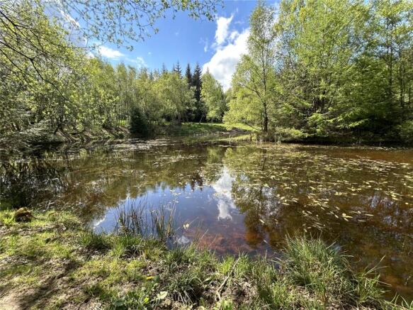
- 0.6 acre pool
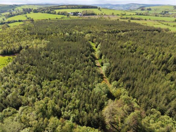
- Tranquil rural setting with far-reaching views
- Multiple road access points
- Internal all-weather trackways
- Sporting, leisure or educational opportunities
- Long term investment opportunity
- Source of wood fuel
- Available a whole or will divide
Description
Description
Mount Wood provides a fabulous opportunity to own a substantial area of mature, maturing and newly planted woodland, with investment, amenity and leisure opportunities. The woodland is predominantly stocked with Sitka spruce, along with smaller proportions of Norway spruce and Western hemlock. Significant broadleaf margains and some mixed broadleaf and coniferous areas complete the woodland with some fine individual specimen trees. The overall woodland structure reflects a varied age profile, with the eastern marginal areas dating from the mid-19th Century. A discrete area in the east was restocked approximately 25 years ago and a substantial area in the central and western parts around 13 years ago. A sizeable pond extending to over half an acre is located to the eastern side of the property and is stocked with coarse fish including Roach, Bream And Tench. Two small, wooded islands provide shelter for wildfowl with Canada Geese and Mallard nesting regularly.
Woodland Management
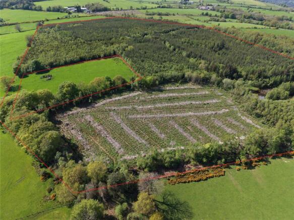
Two small areas were clear felled and replanted under and exisiting felling licence during 2023/24, with restocking comprising of a mixture of Western Hemlock, mixed Firs, Sitka Spruce, Scots Pine, and broadleaved species, bringing added diversity. These young plantations will require ongoing establishment management. The volume and quality of timber has not been assessed and potential purchasers are advised to make their own enquiries as to the viability of any timber harvesting and relevant felling licences.
Felling Licences
As a requirement of the felling licence for the recently restocked areas, the plants must be protected against damage and be adequately weeded for a period of 10 years from replanting. Any failure or losses should be replaced as necessary to provide a stocking density of not less than 2500 stems per hectare evenly distributed over the site. An application for an additional felling licence has been made. A wind damaged area in the east is included in a fresh felling licence application to facilitate a tidying up operation with restocking intended to be primarily with a range of conifers. Further details available on request.
Permitted Development
Permitted development rights allow for the creation of new access tracks or buildings providing these are ‘reasonably necessary for the purposes of forestry’, subject to prior notification and adherence with the criteria as defined within the relevant General Permitted Development Order.
Boundaries
An adjoining triangular parcel of mature woodland fronting the highway to the north is owned by a third party. The boundary is a turf wall and ditch dating from the relevant Enclosure Act of 1810.
Services
Purchasers are advised to make their own enquiries.
Mines, Minerals, Timber & Sporting Rights
So far as they are owned, all mines minerals timer and sporting rights are included in the sale.
Wayleaves, Easements & Rights of Way
The property will be sold subject to any wayleaves, public or private rights of way, easements and covenants and all outgoings whether mentioned in these details or not. The land is traversed by a public footpath and private right of access along the southern margin. A number of permissive paths cross the land, which are registered under the Highways Act and can be withdrawn or altered by the landowner at any time. A small part of the land is subject to a restrictive covenant. Further details available on request.
Tenure
Freehold with vacant possession, except for a narrow strip along the eastern boundary where Possessory Title is held. An application for Title Absolute can be made in 2030.
Local Authority
Shropshire Council. Guildhall, Frankwell Quay, Shrewsbury SY3 8HQ Tel:
Location
Mount Wood is located on the English-Welsh border approximately 1 mile north of Selattyn and 1.5 miles west of Weston Rhyn, north of Oswestry.
Directions
From Oswestry, take the B4579 north towards Weston Rhyn. After approximately 1.3 miles turn right signposted Weston Rhyn. At Wern, turn right onto Station Road, after half a mile take the first exit at the roundabout onto Bronygarth Road. Continue past the church then after 500m fork left. Take the next left and continue on for approximately 1 mile. The woodland will be found on the left hand side. The main access has a noticeable pull-in, with gateway and stile for pedestrian access.
What3 Words
///proposals.recapture.button
Viewings
The Property may be viewed on foot, during daylight hours and with a copy of the sales particulars in hand.
Brochures
ParticularsMount Wood, Selattyn, Oswestry, SY10

NEAREST STATIONS
Distances are straight line measurements from the centre of the postcode- Chirk Station2.1 miles
- Gobowen Station3.3 miles
- Ruabon Station5.6 miles


Notes
Disclaimer - Property reference SHR260016. The information displayed about this property comprises a property advertisement. Rightmove.co.uk makes no warranty as to the accuracy or completeness of the advertisement or any linked or associated information, and Rightmove has no control over the content. This property advertisement does not constitute property particulars. The information is provided and maintained by Berrys, Shrewsbury. Please contact the selling agent or developer directly to obtain any information which may be available under the terms of The Energy Performance of Buildings (Certificates and Inspections) (England and Wales) Regulations 2007 or the Home Report if in relation to a residential property in Scotland.