
Land At Grange Farm, Lamancha, West Linton, EH46
- PROPERTY TYPE
Land
- SIZE
4,211,816 sq ft
391,291 sq m
Key features
- Excellent block of Grade 4.2, 5.1 & 5.2 hill pasture and grazing ground
- Located in a rural yet accessible location with good links to surrounding settlements
- Excellent level of access onto adjacent public roads with links to Edinburgh City By-Pass
- Land offering potential to expand sporting, natural capital and environmental interest
Description
The Land at Grange Farm is situated in a scenic and accessible rural location with the Scottish Borders, adjacent to the settlement of Lamancha about 5.5 miles to the east of the village of West Linton and 7 miles southwest of the popular town of Penicuik. The land benefits from access onto Old Moffat Road and the A701 and is only about 12 miles south of the Edinburgh City Bypass, offering excellent transport links to both the north and south of the country. Penicuik provides a range of day-to-day amenities including a variety of retail and business services, primary and secondary schools. The large retail and industrial park at Straiton, which is located about 11 miles to the northeast, offers a wide selection of services and major retailers including IKEA and Costco.
The nearby train station at Gorebridge, around 14 miles from the land, provides fast rail connections to Edinburgh and beyond. The City of Edinburgh offers a broader range of services, including financial centres, retail and business facilities, and regular mainline railway connections, international airport services are available from Edinburgh Airport.
This part of Midlothian is renowned for its high-quality mixed farming units, and the Land at Grange Farm offers a mix of productive hill pasture and grazing ground well suited to the rearing of livestock. The area is well served by a range of agricultural merchants and suppliers, with several agricultural contractors available to provide additional farming resources if required. The excellent road networks easy access to a number of livestock markets located in Lanark, Stirling and St Boswells offering a choice of outlets for livestock purchases and sales.
Description
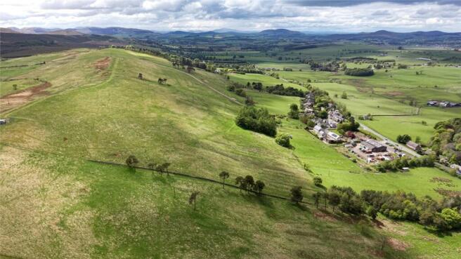
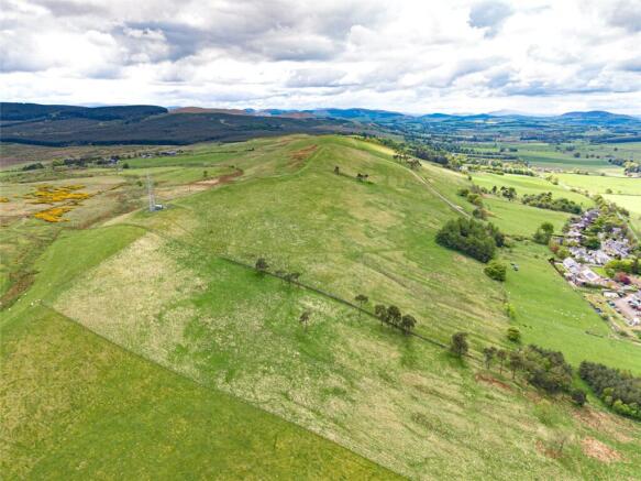
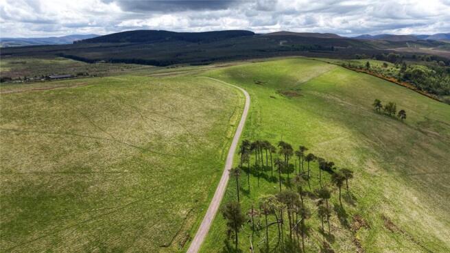
The Land at Grange Farm offers an excellent block of grassland extending to approximately 39.13 Ha (96.69 Acres) in total and is located within a highly accessible location within the Scottish Borders. The land comprises a continuous block of pasture and grazing land which lies in an elevated position to the south of the village of Lamancha. The land is accessed via a privately owned road which leads from Old Moffat Road which connects with the A701 to the north of the subjects. The land has principally been classified as Grade 5.1 and 5.2 by the James Hutton Institute with some smaller areas of Grade 4.2 to the northeast and rises from approximately 305m above sea level at the lowest point towards the west of the holding to approximately 378m above sea level at the highest point of the hill ground. The water supply to the land is natural source. The land is ring fenced with stockproof fencing and is currently utilised for the grazing of livestock.
Method of sale
For sale as a whole.
IACS
All the farmland is registered for IACS purposes.
Nitrate Vulnerable Zone (NVZ)
The Land at Grange Farm is not included within a Nitrate Vulnerable Zone.
Basic Payment Scheme (BPS) 2026
The Basic Payment Entitlements will be available for sale by separate negotiation. Further details of the Basic Payment Entitlement are available from the Selling Agent. Any payments relating to the 2026 scheme year will be retained by the Seller. If applicable, the purchaser(s) will be responsible upon occupation of the subjects of sale to comply fully with the Statutory Management requirements to maintain the farmland in Good Agricultural and Environmental Condition (GAEC) as laid down under the Cross Compliance rules of the Basic Payment Scheme (BPS) 2026 for the remainder of the scheme year.
Less-Favoured Area Support Scheme (LFASS)
All of the land has been designated as being within a Less-Favoured Area.
Directions
From Penicuik head south on the A701 for approximately 3 miles and then turn right at Leadburn to stay on the A701. After approximately 3 miles turn left onto Old Moffat Road and then turn left again to head up the privately owned track. freshen.clattered.basin Post Code EH46 7BD
Viewing
Strictly by appointment with the Selling Agents.
Possession And Entry
Vacant possession and entry will be given on completion or such mutual time to be agreed by the seller and the purchaser(s).
Health & Safety
The property is an agricultural holding and appropriate caution should be exercised at all times during inspection particularly in reference to the farm buildings, farm land and water courses.
Third Party Rights And Servitudes
There are a number of electricity and Openreach poles crossing the land.
Third-party owners of the telecoms mast to the east of the subjects benefit from a right of access over the land to the mast.
The subjects for sale benefit from a right of access over the track A-B to access the land.
The owners of the adjacent property also benefit from a right of access over the route labelled A-B-C-D.
The subjects are sold together with and subject to all existing rights of way, servitudes, wayleaves and others whether contained in the Title Deeds or otherwise, and purchasers will be deemed as satisfied themselves in respect thereof.
Brochures
ParticularsLand At Grange Farm, Lamancha, West Linton, EH46

NEAREST STATIONS
Distances are straight line measurements from the centre of the postcode- Curriehill Station10.6 miles

About Galbraith, Stirling
Suite C1, Stirling Agricultural Centre, Stirling, FK9 4RN


Notes
Disclaimer - Property reference STR230131. The information displayed about this property comprises a property advertisement. Rightmove.co.uk makes no warranty as to the accuracy or completeness of the advertisement or any linked or associated information, and Rightmove has no control over the content. This property advertisement does not constitute property particulars. The information is provided and maintained by Galbraith, Stirling. Please contact the selling agent or developer directly to obtain any information which may be available under the terms of The Energy Performance of Buildings (Certificates and Inspections) (England and Wales) Regulations 2007 or the Home Report if in relation to a residential property in Scotland.