
Threlkeld, Keswick, CA12
- PROPERTY TYPE
Farm House
- SIZE
Ask agent
- TENUREDescribes how you own a property. There are different types of tenure - freehold, leasehold, and commonhold.Read more about tenure in our glossary page.
Freehold
Key features
- Lot 1 - Guide Price £1,200,000.
- Lot 2 - Guide Price £230,000.
- Lot 3 - Guide Price £160,000.
- Lot 4 - Guide Price £425,000.
- Lot 5 - Guide Price £85,000.
- Lot 6 - Guide Price £90,000.
- Lot 7 - Guide Price £270,000.
- Lot 8 - Guide Price £120,000.
- PLEASE NOTE LOTS 1 - 5 INCLUSIVE ARE NOW SOLD SUBJECT TO CONTRACT.
Description
PLEASE NOTE THAT LOTS 1 - 5 INCLUSIVE ARE NOW SOLD SUBJECT TO CONTRACT.
Introduction
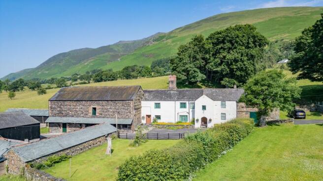
The sale of Stoneraise Farm offers a rare opportunity to purchase an extensive traditional, Lake District fell farm with land ranging from good mowing land to extensive allotment land, together with common grazing rights. The farm comprises a 3 / 4 bedroomed Grade II Listed farmhouse, traditional and modern farm buildings, together with approximately 304.24 acres (123.12 ha) or thereabouts of land, and common land grazing rights all located within the Lake District National Park and Lake District World Heritage site. The property is offered for sale by Private Treaty in up to eight Lots.All of the land benefits from roadside access with it benefitting from a mix of mains and natural water supplies.Location
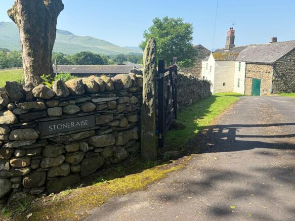
Stoneraise Farm is located approximately ¼ mile off the A66, 5 miles from Keswick and 10½ miles from Penrith and the M6 motorway.
Directions
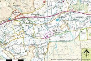
The property is located close to the main A66 approximately 1.6 miles to the north-east of the Lakeland village of Threlkeld. If you are approaching from the west, travel along the A66 passing Threlkeld and continue for approximately 1.6 miles until you reach a turning to your right signposted Wallthwaite. At this point, turn right and continue along this road for approximately 250 metres until reaching a turning to the right. Take this right hand turn and Stoneraise Farm is located approximately 160 metres down this road on the right hand side.
If approaching from the east, pass the hamlet of Troutbeck on the A66 and continue along the A66 for approximately 2¾ miles until reaching the signpost to your left signposted Wallthwaite and then follow the directions above. The location of the property is shown on the plans within these particulars and will be identified by way of PFK sale boards.
What3Words:
What3Words (Lot 1): ///corrupted.fiction.avocado
What3Words (Lot 2): ///toothpick.tailwind.silk
What3Words (Lot 3): ///quicksand.approvals.cats
What3Words (Lot 4): ///digitally.fool.secretly
What3Words (Lot 5): ///blotchy.contact.sobered
What3Words (Lot 6): ///chucked.spoons.orders
What3Words (Lot 7): ///yourself.intrigued.latest
What3Words (Lot 8): ///petrified.swan.save
Local Amenities
Stoneraise Farm is located in the northern Lake District, within the National Park. The village of Threlkeld is approximately 1.6 miles to the west of the farm, and benefits from a primary school, two pubs and a coffee shop. The farm enjoys good access to the A66 which provides easy access to both Keswick and Penrith. Keswick being approximately 5 miles to the west of the farm and benefits from all the amenities you would expect of a small market town including supermarkets, fuel stations, and a secondary school. Penrith is approximately 10½ miles to the east, which again has all the amenities you would expect of a market town, together with providing access to the M6 motorway, having a station on the West Coast Mainline Railway, and a livestock auction market.
Lot 1 - Stoneraise Farmhouse, Buildings & 17.81 Hectares (44.00 Acres) of Agricultural Land
Lot 1 comprises Stoneraise Farmhouse, agricultural buildings and approx. 44.01 acres (17.81 hectares) of agricultural land.
The house is Grade II listed and is a traditional rendered stone under slate roof farmhouse with attached barns.
The house comprises a front door leading into a small porch area (1.4m x 2.11m) which has within it plumbing for a washing machine and a cooker point. This room benefits from a linoleum covered floor with tiled walls for easy cleaning.
A door leading into the dining kitchen (6.2m x 5.92m) with kitchen units and a sink and drainer, a multifuel stove which heats both the hot water for the radiators throughout the house and the water for the house (there is an additional electric immersion which can be used when the stove is not alight), a single glazed sash window to the front elevation of the property with UPVC double glazed window to the rear of the property, wooden beams, two built-in wooden wall cupboards and a night storage heater.
From here is a door leading through to a small hallway which gives access to the stairs, pantry and living room.
The pantry has a stone floor, stone and slate shelves, UPVC double glazed window to the rear of the property.
The door from the dining kitchen into the hall and the door out of the hall into the living room are both wooden studded doors.
Living room (6.18m max x 5m) which houses a multifuel stove within a stone and brick surround fireplace. The room benefits from wooden beams, a night storage heater, a radiator and a wooden sash window to the front elevation of the property.
From the living room is a door into the main hallway of the house which runs the full width of the house and also gains access from a further front door to the property. The hallway has a linoleum covered floor and a radiator.
Two steps lead up from the hallway into a further room which could be used as a living room, playroom, or study (6m x 4.64m). This room has wooden beams, a wooden sash window to the front elevation of the property and a small fireplace with a tiled hearth and surround.
Stairs from the rear hall lead to a small landing area off which is a door which leads into a fourth bedroom / study (2.38m x 5m). This benefits from a UPVC double glazed window to the rear elevation of the property.
Steps lead to the main landing of the property which runs the full length of the house and off the main landing are the following:
Master Bedroom (11.54m x 4.9m max) with a night storage heater, a cast iron fireplace (which is not currently useable), a wooden sliding window to the front elevation of the property, wooden ceiling beams and wood panel walls and a walk-in cupboard.
Bathroom (4.04m x 2.43m max) with WC, wash hand basin, a radiator, panelled bath, walk-in corner shower cubicle with an electric shower, wooden ceiling beams, wood sliding window to the front elevation of the property and wood panelling. A large airing cupboard which houses the hot water cylinder and immersion for the property.
Bedroom 2 (4.34m x 3.6m) with wooden ceiling beams, a wooden sliding window to the front elevation of the property and a door which leads into a small room (2.18m x 2.44m) which could be utilised as a study/dressing room/office.
Bedroom 3 (6.02m x 4.65m) with a night storage heater, wooden sash windows and wooden floorboards.
Attached to the eastern elevation of the property is a stone under slate roof barn (Building 1) which is utilised for general storage purposes. The main section of the barn is lofted and this currently has an open access point which requires to be accessed via a ladder from the outside of the building. This building offers conversion / extension potential subject to obtaining the necessary planning consent.
Attached to the western elevation of the farmhouse is a stone under slate and corrugated tin sheet roofed bank barn (Building 2) with a slate roofed canopy at the front of the property. This barn is Grade II listed. This building is lofted with the ground floor comprising three byres which can be accessed from the front elevation with a further store accessed from either end byre. There is then a further storage area across the rear which is accessed from the western elevation.
On the first floor of the building which is accessed from the bank to the rear of the property is the main hayloft with two stores accessed at either side. The house and barns are boundered on three sides by a grassed area which could be utilised as a garden. In addition, to the front of the property is an orchard area with fruit trees.
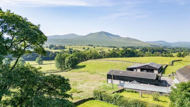
Farm Buildings
Building 3 - Single storey stone under slate roof byres.
Building 4 - Five bay portal framed shed with 2 monopitch extensions all of which have concrete floors. The main section and the end section of this building are open fronted with the central monopitched section benefitting from a sliding door.
Building 5 - Four bay portal framed building utilised for livestock housing.
Building 6 - A monopitched extension of Building 5, with a hardcore floor.
Building 7 - A single storey traditional building of timber construction under a slate roof with sheep handling pens to the outside.
The Land
The land comprising Lot 1 sits within a ring fence surrounding the farm steading. The land is all sown down to permanent pasture, being a mix of grazing land and land capable of being mown.
The land lies between 160 metres - 210 metres above mean sea level, falls within the Severely Disadvantaged Area and is classified as Grade 4 under the former MAFF Land Classification System.
This Lot benefits from common grazing rights on both Saddleback Common- CL0066 and Mungrisdale common - CL0293 - please see Common Rights section for full details.
Lot 2 - 11.69 Hectares (28.89 Acres)
The land comprising Lot 2 benefits from roadside access on two sides, and includes a traditional stone under slate roofed hoggest.
The southern boundary of the land is the river Glenderamakin which provides a natural source of water for some of the fields. Please note the river is designated as a SSSI. The land in the main is good permanent pasture land.
The land lies between 160 metres - 200 metres above mean sea level, falls within the Severely Disadvantaged Area and is classified as Grade 4 under the former MAFF Land Classification System.
This Lot benefits from common grazing rights on both Saddleback Common - CL0066 and Mungrisdale common - CL0293 - please see Common Rights section for full details.
Lot 3 - 9.22 Hectares (22.80 Acres)
The land comprising Lot 3 is all good permanent pasture land, which enjoys roadside access and benefits from a natural water supply in some of the fields via Combe Beck.
The land lies between 200 metres - 210 metres above mean sea level, falls within the Severely Disadvantaged Area and is classified as Grade 3 under the former MAFF Land Classification System.
This Lot benefits from common grazing rights on both Saddleback Common- CL0066 and Mungrisdale common - CL0293 - please see Common Rights section for full details.
Lot 4 - 23.24 Hectares (57.42 Acres)
Lot 4 is an extensive block of land which is a mix of grazing land and land capable of being mown. Several of the parcels enjoy roadside access with the northern boundary of the land being the River Glenderamackin which provides a natural water supply to some of the parcels. Please note the river is designated as a SSSI.
The land lies between 160 metres - 170 metres above mean sea level, falls within the Severely Disadvantaged Area and is classified as Grade 4 under the former MAFF Land Classification System.
This Lot benefits from common grazing rights on both Saddleback Common- CL0066 and Mungrisdale common - CL0293 - please see Common Rights section for full details.
Lot 5 - 9.56 Hectares (23.63 Acres)
Lot 5 comprises a mix of good pasture land and some upland grazing land. There are some sheep holding pens located within Lot 5, and both blocks of land within the Lot benefit from direct roadside access.
The land lies between 210 metres - 340 metres above mean sea level, falls within the Severely Disadvantaged Area with parcel 6723 also lying above the moorland line. The land is classified as Grade 5 under the former MAFF Land Classification System.
This Lot benefits from common grazing rights on both Saddleback Common - CL0066 and Mungrisdale common - CL0293 - please see Common Rights section for full details.
Lot 6 - 7.27 Hectares (17.97 Acres)
Lot 6 is a block of upland grazing which benefits from roadside access and has numerous natural springs which provide a natural water supply for the block of land.
The land lies between 180 metres - 200 metres above mean sea level, falls within the Severely Disadvantaged Area and is classified as Grade 5 under the former MAFF Land Classification System.
Lot 7 - 30.93 Hectares (76.42 Acres)
Lot 7 comprises a large upland allotment, which provides excellent rough grazing, is relatively flat in topography and benefits from roadside access. This block of land benefits from a natural water supply.
The land lies between 200 metres - 220 metres above mean sea level, falls within the Severely Disadvantaged Area with parcel 4317 falling above the moorland line and parcel 8922 falling below it. The land is classified as Grade 5 under the former MAFF Land Classification System.
Lot 8 - 13.40 Hectares (33.11 Acres)
Lot 8 is an upland allotment which benefits from roadside access. This parcel of land benefits from a mains water supply.
The land lies between 200 metres - 210 metres above mean sea level, falls within the Severely Disadvantaged Area and is classified as Grade 5 under the former MAFF Land Classification System.
General Remarks, Reservations & Stipulations
Method of Sale
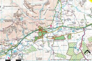
Stoneraise Farm is to be offered for sale by Private Treaty in up to eight Lots.
The Vendor and sole selling Agents reserve the right to alter or divide the property or to withdraw or exclude any of the property at any time.
The Vendor reserves the right to vary any of the terms and conditions of sale or to change the method of sale without notice. For this reason, we recommend likely Purchasers should register their interest with the sole selling Agents as soon as possible in order that they are kept abreast of any changes to the marketing of the land.
Tenure
The property is offered for sale freehold with vacant possession upon completion.
Money Laundering Obligations
As a requirement of the Money Laundering Regulations (Money Laundering Terrorist Financing and transfer funds (information on the payer) regulations 2017) relating to property transactions, the selling agents are obliged to carry out Customer Due Diligence checks on all prospective Purchasers prior to any transaction being completed. Please contact the selling agents for the information required to register.
Water
The land benefits from a mix of mains and natural water supplies. Please refer to each individual Lot for full details.
Access
All Lots benefit from direct roadside access.
Wayleaves, Easements, Covenants & Rights of Way
The property is sold subject to all rights including rights of way, whether public or private, light, support, drainage, water and electricity supplies and other rights and obligations and easements, quasi easements and restrictive covenants and all existing and proposed wayleaves for masts, pylons, stays, cables, drains, and water, gas and other pipes, whether or not referred to in these particulars.
In particular, it should be noted that there is a public footpath which runs east to west from the public highway through Stoneraise farmyard and exiting the land on its western side within Lot 1.
Lot 2 has a footpath running from the stone hoggest to the public highway.
Lot 4 has two public footpaths running across the fields on the most western boundary which exits the land at Guardhouse Bridge.
Any Purchaser will be deemed to have satisfied themselves as to the nature of such restrictions and are advised to contact the Vendor's Solicitors for details:
Arnison Heelis Solicitors, 1 St. Andrew's Place, Penrith, Cumbria, CA11 7AW.
Email: (Bethanny McDermott acting).
Sporting, Shooting & Mineral Rights
The sporting, shooting and mineral rights are excluded from the sale due to all of the land being former copyhold land of either the Manor of Threlkeld or the Manor of Matterdale.
Basic Payment Scheme (BPS)
The land is sold without any entitlement to any BPS money nor any De-linked payment.
Common Rights
Stoneraise benefits from the following common rights:
325 ewes and shearlings, together with 120 hoggs on Saddleback Common- CL0066 and 200 ewes and shearlings, together with 80 hoggs on Mungrisdale Common - CL0293 in total.
If the farm is sold in Lots, it is anticipated that the common rights will be attributable to the individual Lots in the following numbers as detailed within the particulars.
The above figures are provisional and subject to confirmation by the Commons Authority at Westmorland and Furness District council.
There are no common rights attached to the land within Lots 6, 7 and 8.
It should be noted that these rights have not been exercised for many years and any prospective Purchaser should make their own enquiries in regard to the position with regard to exercising these rights.
Council Tax
Stoneraise Farm falls within Council Tax Band E within the Westmorland and Furness District Council area.
Quotas & Environmental Schemes
The farm is subject to a Mid Tier Countryside Stewardship Scheme which comes to an end on 31st December 2026. Full details of the Agreement are available from the sole selling Agents. The Purchaser(s) will be expected to abide by the requirements of the Scheme until its completion and the monies which are payable upon the requisite Lots will be paid to the Purchaser(s) by the Vendor upon receipt of the payment from the RPA on a pro rata basis, dependent upon length of ownership during 2026.
Land Status
Lots 1, 2, 3 and 4 are classified as Grade 4 under the former MAFF Land Classification System. Lots 5, 6, 7 and 8 are all classified as Grade 5 under the former MAFF Land Classification System.
Boundary Responsibility
As far as the Vendor is aware the responsibility for the boundaries are shown on the sale plan by inward facing ‘T’ marks. When no 'T' mark is shown, there is no further information available.
Plans & Schedule of Areas
The plans attached to these particulars are based on Rural Land Registry data and are for reference only. Any prospective Purchaser(s) will have deemed to have satisfied themselves of the land and schedule.
Flood Risk
Stoneraise Farmhouse, farm buildings and the barn located within Lot 2 all fall within Flood Zone 1 being an area with a low probability of flooding.
The land which lies adjacent to the River Glenderamackin falls within a mix of Flood Zones 2 and 3 which have a higher probability of flooding, these being parcels within Lots 2 and 4. The remaining land falls within flood zone 1.
Fixtures & Fittings
Any fixtures and fittings referred to in these particulars will be included in the sale, unless stated otherwise.
Measurements
The measurements are approximate and must not be relied upon.
Control of Asbestos at Work Regulations
The Regulations came into force on 21st November 2002. Any Purchaser(s) should satisfy themselves of the nature of any asbestos material in the property.
Health & Safety
Given the potential hazards of agricultural land, we request that you take as much care as possible when making your inspection of the property for your own personal safety, particularly around any livestock.
Viewing & Further Information
Viewings of Lot 2 - 8 is permitted during any daylight hour provided a copy of these particulars is to hand.
Viewing of Lot 1 is strictly by appointment only. Therefore, any interested parties must contact the Selling Agents in order to arrange a convenient time for an inspection to be undertaken.
When inspecting any of the property, please do not obstruct any gateways, the public highway or any property belonging to a third party whilst viewing the land.
Please do not disturb any livestock grazing the land and all viewings are to be undertaken on foot on all occasions and NO vehicular access is to be taken to the land.
For all enquires, please contact Jo Edwards at PFK Rural for further information on or by email
Services
Stoneraise Farmhouse benefits from mains electricity, a private water supply, and foul drainage is is dealt with via a septic tank. It should be noted that the septic tank has not been inspected, and may not meet current requirements and prospective Purchasers should make their own investigations. A phone line is connected to the Farmhouse, and it benefits from Broadband.
The property benefits from solid fuel central heating via a back boiler from a multifuel stove together with electric storage heaters. In addition, the multifuel stove heats the water although there is a separate electric immersion for use when the stove is not lit.
The buildings benefit from mains electricity and a private water supply.
The land benefits from a mix of natural and mains water throughout.
Authorities
Cumbria County Council
Civic Centre, Rickergate, Carlisle, CA3 8QG
Tel:
Web:
Westmorland & Furness Council
Town Hall, Penrith, CA11 7QF
Tel:
Web:
Lake District National ParkMurley Moss, Oxenholme Road, Kendal, LA9 7RL
Tel:
Email:
United Utilities
Dawson House, Great Sankey, Warrington, WA5 3LW
Tel:
Email:
Web:
General Reservations
The right is reserved to the Vendor(s) to amend, alter and incorporate fresh provisions as appropriate in respect of the above matters.
First Edition: June 2026
Particulars Prepared: May 2026
Photographs Taken: August 2025 & May 2026
Brochures
Brochure- COUNCIL TAXA payment made to your local authority in order to pay for local services like schools, libraries, and refuse collection. The amount you pay depends on the value of the property.Read more about council Tax in our glossary page.
- Ask agent
- PARKINGDetails of how and where vehicles can be parked, and any associated costs.Read more about parking in our glossary page.
- Ask agent
- GARDENA property has access to an outdoor space, which could be private or shared.
- Yes
- ACCESSIBILITYHow a property has been adapted to meet the needs of vulnerable or disabled individuals.Read more about accessibility in our glossary page.
- Ask agent
Energy performance certificate - ask agent

Add an important place to see how long it'd take to get there from our property listings.
__mins driving to your place
Affordability

Get an instant, personalised result:
- Show sellers you’re serious
- Secure viewings faster with agents
- No impact on your credit score
Notes
Staying secure when looking for property
Ensure you're up to date with our latest advice on how to avoid fraud or scams when looking for property online.
Visit our security centre to find out moreDisclaimer - Property reference d2c1580a-77e0-4ed0-aef1-9d4d66693630. The information displayed about this property comprises a property advertisement. Rightmove.co.uk makes no warranty as to the accuracy or completeness of the advertisement or any linked or associated information, and Rightmove has no control over the content. This property advertisement does not constitute property particulars. The information is provided and maintained by PFK, Penrith. Please contact the selling agent or developer directly to obtain any information which may be available under the terms of The Energy Performance of Buildings (Certificates and Inspections) (England and Wales) Regulations 2007 or the Home Report if in relation to a residential property in Scotland.
Auction Fees: The purchase of this property may include associated fees not listed here, as it is to be sold via auction. To find out more about the fees associated with this property please call PFK, Penrith on 01760 308696.
*Guide Price: An indication of a seller's minimum expectation at auction and given as a “Guide Price” or a range of “Guide Prices”. This is not necessarily the figure a property will sell for and is subject to change prior to the auction.
Reserve Price: Each auction property will be subject to a “Reserve Price” below which the property cannot be sold at auction. Normally the “Reserve Price” will be set within the range of “Guide Prices” or no more than 10% above a single “Guide Price.”
*This is the average speed from the provider with the fastest broadband package available at this postcode. The average speed displayed is based on the download speeds of at least 50% of customers at peak time (8pm to 10pm). Fibre/cable services at the postcode are subject to availability and may differ between properties within a postcode. Speeds can be affected by a range of technical and environmental factors. The speed at the property may be lower than that listed above. You can check the estimated speed and confirm availability to a property prior to purchasing on the broadband provider's website. Providers may increase charges. The information is provided and maintained by Decision Technologies Limited. **This is indicative only and based on a 2-person household with multiple devices and simultaneous usage. Broadband performance is affected by multiple factors including number of occupants and devices, simultaneous usage, router range etc. For more information speak to your broadband provider.