

Hanbury, Bromsgrove, Worcestershire
- PROPERTY TYPE
Land
- SIZE
1,989,385 sq ft
184,820 sq m
Key features
- A well located and useful block of arable land
- With a broadleaf deciduous woodland
- Situated on the edge of Hanbury, Worcestershire
- Road frontage and access from the public highway
- No overage/ clawback
- For sale by private treaty as a whole
- In all about 45.67 acres (18.48 ha)
Description
Description
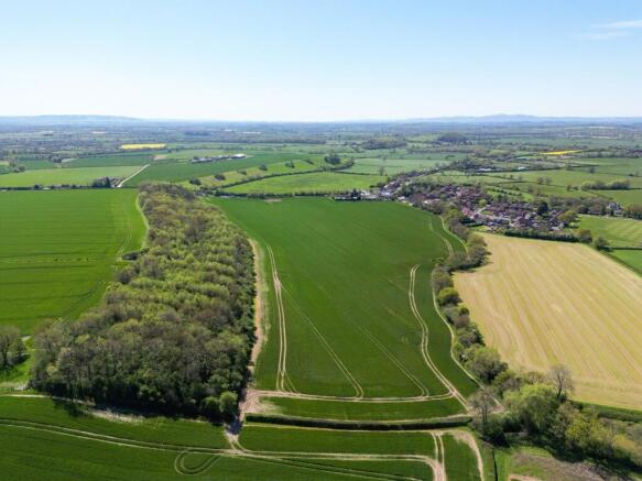
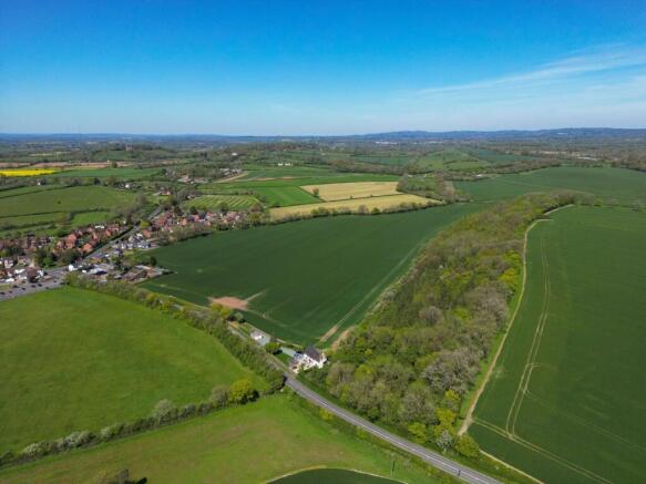
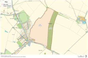
Oxpasture Bank extends as a whole to approximately 45.67 acres (18.48 ha) which is made up of:
• 33.60 acres (13.60 ha) of Grade 3 arable land
• and 12.07 acres (4.89 ha) of broadleaf deciduous woodland
Oxpasture Bank is bounded by mature hedgerows with a stream running along the eastern boundary. The land benefits from direct access off the B4090 highway. The arable land has been in a cereal based rotation for many years and is currently cropped with Winter Wheat. The woodland has been used by a local shoot.
Situation
The land is situated on the eastern edge of Hanbury.
Hanbury is home to the National Trust’s Hanbury Hall with other local amenities including Hanbury C of E First School and St Mary the Virgin church together with the Vernon public House.
Local facilities can be found in nearby Bromsgrove and Droitwich Spa, including railway stations and good access to the M5 and M42 which links to the M40.
The city of Worcester is just to the south and has all that would be expected of a city.
Services
The purchaser is responsible for establishing the cost for the connection of the appropriate services/utilities to the property. No services are currently connected.
Tenure and Possession
The land is sold freehold and vacant possession will be available on completion subject to a Farm Business Tenancy with J H Wormington & Son Ltd which expires on the 28th September 2026. The Property is registered with the Land Registry under title number WR90339.
Method of sale
The property is offered for sale by Private Treaty method. However the vendor reserves the right to conclude the sale by an alternative method if required.
Land Quality and Soil Type
The land is classified as Grade 3 according to the Natural England Regional Agricultural Land Classification Maps. The soil may be described as slowly permeable slightly acid but base-rich loamy and clayey soils.
Overage
No overage or clawback provisions will be included in the sale.
Sporting, Mineral and Timber Rights
The sporting, mineral and timber rights will be transferred with the freehold title where owned.
Designations
The Property lies within a Surface Water Nitrate Vulnerable Zone (NVZ) Area and is subject to the usual restrictions.
The property is within the Greenbelt.
Value Added Tax (VAT)
We understand the property has not been opted to tax and therefore VAT will not be chargeable in addition to the purchase price.
Environmental Schemes
We understand that the land is not currently entered into any schemes.
Local Authority
Wychavon District Council
Public rights of way, wayleaves and easements
The Property is sold subject to and with the benefit of all easements, quasi easements, wayleaves and rights of way both declared and undeclared.
The are two public footpaths that follow both the eastern and western boundaries
Planning
The selling agents will not provide advice/guidance on the planning history for the property/land. Interested parties are advised to make their own investigations. It is assumed that enquiries have been satisfied, prior to an offer being made.
Anti Money Laundering Regulations (AML)
In accordance with Anti Money Laundering Regulations (AML), we are required to request forms of identification and carry out due diligence on any parties connected to a successful offer. Should an offer be made on behalf of a business/company, AML due diligence will also be necessary. Proof/source of funding must be supplied, prior to offer acceptance.
Plans and boundaries
The plans within these particulars are based on Ordnance Survey data and provided for reference only. They are believed to be correct but accuracy is not guaranteed.
The purchaser shall be deemed to have full knowledge of all boundaries and the extent of ownership. Neither the vendor nor the vendor’s agents will be responsible for defining the boundaries or the ownership thereof.
Viewings
Strictly by appointment through Fisher German LLP.
On foot at any reasonable time during daylight hours, with a copy of these particulars in hand.
Directions
Post Code: B60 4HH
what3words: ///behalf.bolt.chemistry
Brochures
ParticularsHanbury, Bromsgrove, Worcestershire

NEAREST STATIONS
Distances are straight line measurements from the centre of the postcode- Bromsgrove Station4.0 miles
- Droitwich Spa Station4.6 miles
- Redditch Station5.2 miles


Notes
Disclaimer - Property reference WOR260137. The information displayed about this property comprises a property advertisement. Rightmove.co.uk makes no warranty as to the accuracy or completeness of the advertisement or any linked or associated information, and Rightmove has no control over the content. This property advertisement does not constitute property particulars. The information is provided and maintained by Fisher German, Worcester. Please contact the selling agent or developer directly to obtain any information which may be available under the terms of The Energy Performance of Buildings (Certificates and Inspections) (England and Wales) Regulations 2007 or the Home Report if in relation to a residential property in Scotland.