
Kirkbride Airfield, Kirkbride, Wigton, Cumbria, CA7

- PROPERTY TYPE
Land
- SIZE
7,003,141 sq ft
650,614 sq m
Key features
- 32.84 acres of runways, hardstanding & helipad
- Control Tower, club house & offices
- Modern hangar with taxiway
- 127.93 acres of grassland & arable
- Established aviation fuel sales location
- Potential for diversification to commercial, logistics, storage, leisure or holiday uses (subject to consents)
- Accessible location with good road connections
- Total annual income in the region of £60,000 per annum
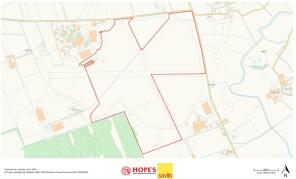
- In all about 160.77 acres (65.06 Hectares)
Description
Offer deadline set - Monday 7th September 2026 - 12 noon - please contact the selling agents for offer forms.
Description
OFFER DEADLINE - MONDAY 7th SEPTEMBER - 12 NOON.
PLEASE CONTACT THE SELLING AGENTS FOR OFFER FORMS
HISTORY
Royal Air Force Kirkbride opened in June 1939 predominantly as an aircraft repair depot, far enough away from the threat of enemy aircraft. After the Second World War, the site remained open as a maintenance unit and a disposal airfield for redundant aircraft, closing in 1960.
SUMMARY
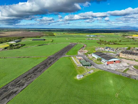
The sale comprises of a significant portion of the former World War II RAF Kirkbride, including significant runways, hard standings and access ways. Between the runways and service roads are a series of agricultural fields which are predominantly good quality meadowland. The sale also includes a control tower and club house with office, WC and kitchen facilities, adjacent to which is a steel framed aircraft hangar. There is also a helipad near the control tower and a further redundant building in the rougher pasture to the south. Beyond aviation, the site is used for a number of events which generate additional income, such as motorsports, storage and demonstrations. Kirkbride Airfield also offers a significant range of opportunities for further development and commercialisation, subject to consents. The scale of the site is well suited to storage, logistics, manufacturing or leisure uses.
HANGAR
The hangar is a steel portal frame building with concrete apron adjacent (20m x 24m). The building provides storage for aircraft and is a steel frame construction, with steel profile roof and cladding and a concrete floor.
DISUSED BUILDING
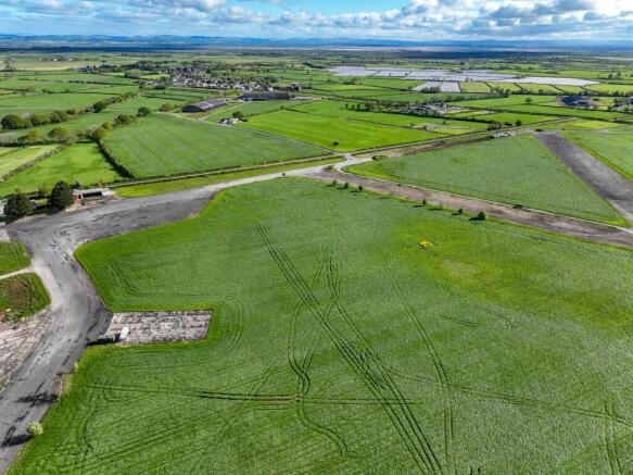
South of the core site, is a brick built former service building associated with the historic RAF use, this sits within a grassland parcel and although derelict, could be repurposed or developed (subject to consents).
CONTROL TOWER
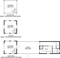
Control Tower extends to approximately 753 sq. ft. over three floors and includes a reception, club house, meeting rooms and office, with WC and kitchen facilities. This could be further developed into a range of uses (subject to consents).
RUNWAYS
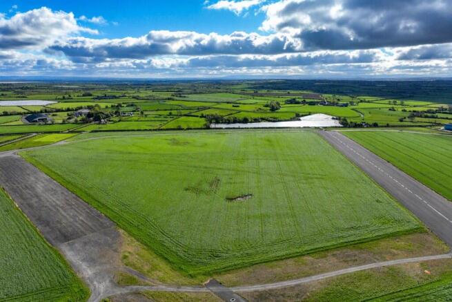
The principal runway is predominantly included in the sale, with two sections leased from third party adjoining owners, to complete the full runway for ease of operation. The secondary runway is partially grassed over, and the remainder used for model aircraft, storage or events.
LAND
Between the runways and service roads are a series of agricultural fields which are predominantly good quality meadowland, but have historically provided arable acreage. There are further areas of land which are rougher pasture to the south. The land is predominantly Grade 3 with soils from the ‘Rockcliffe’ series, typical to the area, a deep silty and fine sandy soil.
BREAKDOWN OF AREAS:
127.93 acres of arable and temporary grassland.
32.84 acres of buildings, runways, former runways and perimeter tracks.
23.18 acres of permanent pasture and rough grazing, including the dog agility field.
Field schedule and accompanying plan available on request from the joint selling agents.
Acreage: 160.77 Acres
Additional Info
TENURE - The site is occupied on a series of short term arrangements, the farmland being let on annual grazing or mowing licences to local farmers, the hangar building provides light aircraft storage. The control tower and office forms a base for a company operating from the site selling aviation fuel. There is a small paddock to the north east corner adjacent to the road junction which is occupied and used for a dog walking and exercising business. Other income streams include grant schemes, such as the sustainable farming incentive scheme over the farmland, aircraft landing fees and various other short terms uses, such as demonstration days, storage and motorsport events.
RIGHTS OF WAY, EASEMENTS & WAYLEAVES - The property is sold subject to and with the benefit of all wayleaves, easements and rights of way whether public or private whether mentioned or not. Typical of former airfields, various reciprocal private rights of way cross land, runways and service roads.
SERVICES - Mains electricity (60kva 3 phase supply) and main water, with private drainage. The private drainage system is unlikely to comply with the current regulations and will require replacement by the purchaser with a new system.
SUBSIDIES & GRANTS - The land is registered on the Rural Land Registry, the owners have claimed and will retain the Basic Payment (BPS) and any subsequent payments based on previous entitlements and historical claims. We are not aware of any stewardship schemes or agreements, the land is entered into a Sustainable Farming Incentive (SFI) Scheme which is non-transferable and will terminate when the property is sold.
SPORTING RIGHTS - The sporting rights are included in the sale, in so far as they are owned.
MINERAL RIGHTS - The mineral rights are included in the sale, in so far as they are owned.
SALE CONDITIONS - The property is sold without sale restrictions, overage or clawback.
LOCAL AUTHORITY - Cumberland Council
ENERGY PERFORMANCE CERTIFICATE - Control Tower: Band E
BUSINESS RATES - We understand no business rates are paid for the site.
TENURE - The freehold of the property is offered for sale with vacant possession on completion, subject to the aforementioned licences and agreements.
DESIGNATIONS - The land adjoins, but is not part of the South Solway Mosses National Nature Reserve.
SOLICITORS - Minihan McAlister, Warwick Mill Business Park, Carlisle, CA4 8RR
METHOD OF SALE - Kirkbride Airfield is offered for sale by private treaty as a whole, offers for part may be considered. All prospective purchasers are encouraged to register their interest with Savills or Hope’s Land Agency.
NEAREST POSTCODE - CA7 5HP
WHAT3WORDS - ///northward.tripods.happening
VIEWING - Strictly by appointment with the joint selling agents Savills and Hope’s Land Agency.
HEALTH & SAFETY - Given the potential hazards around a working airfield all viewers must make formal appointments to visit the site, and be as vigilant as possible when inspecting for their own personal safety and only view within preagreed appointments.
Brochures
Web DetailsEnergy Performance Certificates
EPC Rating GraphKirkbride Airfield, Kirkbride, Wigton, Cumbria, CA7

NEAREST STATIONS
Distances are straight line measurements from the centre of the postcode- Wigton Station4.1 miles
Notes
Disclaimer - Property reference YOR260011. The information displayed about this property comprises a property advertisement. Rightmove.co.uk makes no warranty as to the accuracy or completeness of the advertisement or any linked or associated information, and Rightmove has no control over the content. This property advertisement does not constitute property particulars. The information is provided and maintained by Savills Rural Sales, York. Please contact the selling agent or developer directly to obtain any information which may be available under the terms of The Energy Performance of Buildings (Certificates and Inspections) (England and Wales) Regulations 2007 or the Home Report if in relation to a residential property in Scotland.