
Land Near High Nibthwaite, Nibthwaite, Cumbria

- PROPERTY TYPE
Land
- SIZE
417,740 sq ft
38,809 sq m
Key features
- Extending in all to circa 9.59 acres (3.88 hectares) and of high amenity value
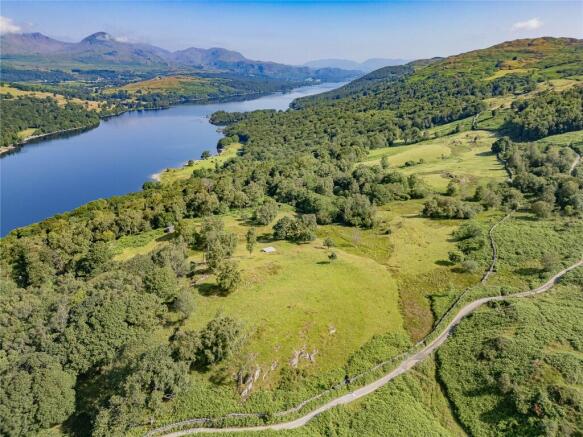
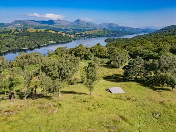
- Elevated position with outstanding views over Coniston Water
- A combination of open grazing, mature broadleaved trees and shrubs and areas of recent planting
- Small orchard of six fruit-bearing trees (four apple and two damson)
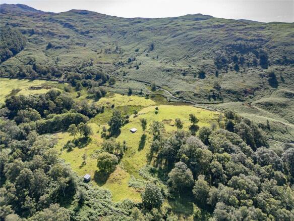
- Timber platform and timber shed housing a compostable WC, both included in the sale
- Ideal opportunity for those wanting a picturesque and tranquil parcel of land within the Lake District National Park [UNESCO World Heritage Site]
- Of interest to amenity purchasers and local land and property owners
Description
The Land Extending to approximately 9.59 acres (3.88 hectares)
[Edged Red on the Sale Plan]
An idyllic single parcel of grazing and amenity land, occupying an elevated position above High Nibthwaite with incomparable views over Coniston Water and across the surrounding Lakeland fells. The land adjoins open common land along its easterly boundary.
The land comprises a combination of sound grazing, interspersed with a fine variety of mature trees and ornamental shrubs, supplemented by areas of recent planting. The mature trees comprise a mix of broadleaved species.
At the western end of the field is a small orchard of six fruit trees, comprising four apple and two damson, planted by the current vendors several years ago. All six trees are fruit bearing.
Boundaries comprise predominantly drystone walls, which are deemed stockproof.
In the centre of the field parcel lies an elevated, rectangular timber platform, with steps leading up to it, which the vendors have historically used to site a teepee when visiting the land. In addition, a small timber shed is positioned along the westerly boundary, housing a compostable W.C.
Directions
Heading northwest along the A5092 from Greenodd roundabout, continue along through the hamlet of Penny Bridge. After approximately 2 miles take the right turning onto the A5084, signposted Coniston & Torver. Continue for a further mile and then take the right hand turn signposted Nibthwaite. Continue along this road and after passing over the bridge, take an immediate left towards High Nibthwaite. Head along this unnamed public highway until you reach the small hamlet of High Nibthwaite.
For viewing purposes, the land can then be accessed on foot via the fellside track leading up from High Nibthwaite, the gateway for which can be found on the eastern periphery of the hamlet and at what3words: relief.javelin.heaven. The gateway into the land is located circa 0.5 miles up this track (what3words: sonic.flipper.survived )– with the access route shown dashed purple on the plan included within these particulars of sale.
Those viewing the land are advised to park considerately in High Nibthwaite and walk up to the land via the track. For the purposes of viewing the land, please do not attempt to access the land with a vehicle. Please see the Viewings section for further details.
What3Words: sway.afraid.climate
Grid Reference: SD
Location
The land is situated on the fellside above and to the direct north of the hamlet of High Nibthwaite, towards the southern end of Coniston Water, within the Lake District National Park. The land occupies an elevated position, adjoining open common land, with outstanding views over the lake and across the surrounding landscape.
By road, the market town of Ulverston lies approximately 9 miles to the south of the land, with popular Lakeland village of Coniston circa 7 miles to the north. Junction 36 of the M6 motorway is approximately 25 miles to the east.
Access
Vehicular access to the land is only available by 4x4 vehicle, via the track leading from High Nibthwaite up and across the adjoining common.
Access to the land is taken along a track which leads up through Bethecar Moor Common (CL189). This common abuts the land's easterly boundary. The land does not, however, form part of the common.
There are two gateways into the land: the first is positioned along the easterly boundary and is accessed directly off the track; the second is positioned in the southernmost corner of the parcel and is accessed by veering off the main track and along a short section of a further track. The gateways are marked ‘A1’ and ‘A2’ on the enclosed sale plan.
Services
Tenure
Freehold.
Vacant possession upon completion.
Water Supplies The land is understood to benefit from natural water supplies.
Planning Authority Lake District National Park Authority –
Mines and Minerals Included, insofar as we are aware.
Sporting Rights Included, insofar as we are aware.
Wayleave and Easements
The sale is subject to all existing rights of way, drainage, light air support and other easements whether mentioned in these particulars or not.
Boundaries
The responsibility of the boundary fences are indicated with ‘T’ marks on the sale plan where known and are from the information provided by the sellers and are believed to be correct.
Sale Plan
The Sale Plan has been prepared by the Selling Agent for the convenience of the prospective purchasers. It is deemed to be correct, but any error, omission or misstatement shall not affect the sale. Purchasers must satisfy themselves as to accuracy.
Method of Sale
The property is offered for sale by private treaty.
Viewings
The land may be inspected at any reasonable time by prospective purchasers, on foot only, provided a copy of these particulars are in possession. Those viewing are advised to park considerately in High Nibthwaite and walk up to the land via the track. We kindly request that all those viewing the land leave gates as found.
Important Note: For the purposes of viewing the land, please do not attempt to access the land with a vehicle. Access to be taken along the fellside track on foot only.
Brochures
ParticularsLand Near High Nibthwaite, Nibthwaite, Cumbria

NEAREST STATIONS
Distances are straight line measurements from the centre of the postcode- Kirkby-in-Furness Station6.6 miles


Notes
Disclaimer - Property reference KEN260087. The information displayed about this property comprises a property advertisement. Rightmove.co.uk makes no warranty as to the accuracy or completeness of the advertisement or any linked or associated information, and Rightmove has no control over the content. This property advertisement does not constitute property particulars. The information is provided and maintained by H&H Land & Estates, Penrith. Please contact the selling agent or developer directly to obtain any information which may be available under the terms of The Energy Performance of Buildings (Certificates and Inspections) (England and Wales) Regulations 2007 or the Home Report if in relation to a residential property in Scotland.