Grade 1 Arable Land, Holbeach Road, Spalding
Business rates & charges may apply

- SIZE
Ask agent
- SECTOR
Farm land for sale
Description
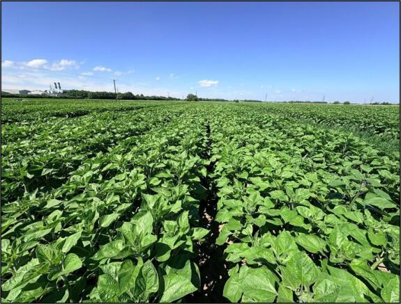
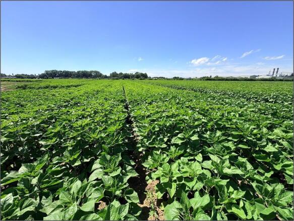
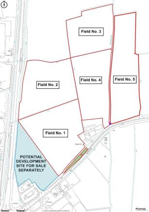
An opportunity to acquire 18.80 Hectares (46.47 Acres) or thereabouts of Grade I agricultural land situated to the North of Holbeach Road, Spalding, Lincolnshire. The land is shown edged red on the enclosed Site Plan and coloured red on the enclosed Aerial Location Plan. The land is Freehold and currently offered with the benefit of Vacant Possession subject to a right of Holdover.
LOCATION:
The land is located to the North of Holbeach Road and East of the A16, Spalding, Lincolnshire. The land is approximately 2 miles North-East of Spalding. The land has good access to the A16 with the Holbeach Road roundabout being the immediate South of the land.
What 3 Words Location:
Eastern Land Parcel Access - ///fortress.shelf.thread
METHOD OF SALE:
The land is offered For Sale by Informal Tender. Please complete the Tender Form and submit this to the Selling Agents prior to the Deadline of 12 noon on Wednesday 26th August 2026. If the Tender Form is not attached to these particulars, please request this from the Agricultural Department at R. Longstaff & Co LLP - Telephone: (Option 4).
LAND AND SOILS CLASSIFICATION:
The land parcels are classified as Grade I agricultural land on the former Ministry of Agriculture, Fisheries & Food land classification map of England and Wales. The actual soil type is further described by the Soil Survey of England and Wales classes the soil as being of the Wallasea 2 Association of Soils which is described as 'Deep stoneless clayey soils, calcareous in places. Some deep calcareous silty soils. Flat land often with low ridges and giving a complex soil pattern' and capable of growing 'Winter cereals and some sugar beet, potatoes, cereals and field vegetables'.
SCHEDULE OF AREA AND BACK CROPPING:
Please refer to Particulars.
It should be noted that Field 1 currently includes the land which has potential for roadside services and other similar uses (subject to planning) as shaded blue on the attached plan. The boundary line dividing the two parcels of land will be defined by the Selling Agents once the current crop has been harvested.
It should also be noted Field 1 includes an area of grass extending to approximately 0.10 Hectares (0.25 Acres) running parallel with the main road and the Lord´s Drain to the South as shown shaded in green on the enclosed plan.
ACCESS:
The arable land as outlined in red on the plan within these particulars (excluding potential roadside services site - blue shaded) is accessed via the eastern entrance into Field 5. This leads directly off the Holbeach Road (A151) and is shared entrance with a neighbour. Access is then possible over ´Wykeham Drain´ into Field 4. The boundary around the yard (excluded from the sale) and house (available by separate negotiation) will be further delineated after the current crop has been harvested.
UNDERDRAINAGE:
A Land Scheme was undertaken on the majority of the land in 2011 and a Land Drainage Plan covering the relevant fields is available from the Selling Agent.
TENURE:
The tenure of the land is Freehold and is offered with the benefit of Vacant Possession subject to a right of Holdover to harvest any crop on the land at the time of completion.
DEVELOPMENT POTENTIAL:
The land is situated adjacent to the main A16 / East side of the town and offers longer term development potential (subject to obtaining the necessary planning consents). The arable land is being offered for sale without any Overage or Clawback provisions.
SERVICES:
Overhead powerlines cross the land to serve adjacent properties, but no services connected to any of the land. Neither the Vendor nor the Agents make any guarantees as to the availability of services and interested parties must make their own enquiries direct with the service providers concerned as to the availability, practicality and cost of providing all necessary services to the land as required.
RIGHT OF WAY, WAYLEAVES AND EASEMENTS ETC:
The land is sold subject to, and offered with, the benefit of all existing rights, including rights of way, whether public or private, light, support, drainage, water, electricity, and other rights, easements, quasi-easements, and all wayleaves, whether referred to specifically in these Particulars or not. We are not aware of any Public Rights of Way which affect the land. The Internal Drainage Board own the drain which divides Fields 3 & 4 from Field 5. They also have Bylaw strips adjacent to some of the drains to facilitate maintenance access.
There is a formal Right of Way over the culvert between Field No.4 and Field No.5 This is shown coloured purple on the enclosed plan.
TENANTRIGHT AND DILAPIDATIONS:
There will be no claim for Tenantright and there will be no claim allowed against the outgoing Licensee for Dilapidations (if any).
ABSTRACTION LICENCES & CONTRACTS:
There are no Abstraction Licences or Contracts included within the sale of the land.
RIGHT OF HOLDOVER:
The land will be subject to a Right of Holdover until the Sunflowers have been harvested with a longstop date no later than the 31st October 2026 being in place.
SPORTING RIGHTS & MINERALS RIGHTS:
The Sporting Rights are included in the sale as far as owned by the Seller. The Mineral Rights are included in the sale as far as owned by the Seller.
DELINKED PAYMENT & STEWARDSHIP SCHEMES:
The Vendor will continue to receive the delinked payment. The land is not entered into any Stewardship Schemes.
DRAINAGE RATES:
Drainage rates are payable to the South Holland Internal Drainage Board.
BOUNDARIES:
The successful purchaser shall be deemed to have full knowledge of boundaries and rights of way (if any) which have or will affect the land. As stated, the boundaries are to be further delineated upon the harvesting of the current crop.
VALUE ADDED TAX:
Should a sale of the land or any right attached to it become a chargeable supply for the purposes of VAT, such Tax will be payable by the Purchaser (s) in addition to the contract price. All Guide Prices quoted, or prices discussed are exclusive of VAT. In the event the property or any part thereof, any rights, contractors, or quotas or Entitlements become a chargeable supply for the purpose of VAT any such taxes will be payable in addition to the purchase price at the appropriate rate.
PLANS, AREAS AND SCHEDULES:
The plans and areas have been prepared as accurately as reasonably possible and are based on the Ordnance Survey Plans. The plans included in these Particulars are published for convenience and / or identification purposes only and although believed to be correct, the accuracy cannot be guaranteed. The purchaser(s) will be deemed to have satisfied themselves as to the description and extent of the property and the ownership of the boundaries.
VIEWING:
Viewing is possible during daylight hours with a set of these sales particulars to hand. Any parties viewing the land do so entirely at their own risk and are responsible for ensuring their own safety.
Brochures
Grade 1 Arable Land, Holbeach Road, Spalding

NEAREST STATIONS
Distances are straight line measurements from the centre of the postcode- Spalding Station1.8 miles
Notes
Disclaimer - Property reference 101505033044. The information displayed about this property comprises a property advertisement. Rightmove.co.uk makes no warranty as to the accuracy or completeness of the advertisement or any linked or associated information, and Rightmove has no control over the content. This property advertisement does not constitute property particulars. The information is provided and maintained by Longstaff Chartered Surveyors, Spalding. Please contact the selling agent or developer directly to obtain any information which may be available under the terms of The Energy Performance of Buildings (Certificates and Inspections) (England and Wales) Regulations 2007 or the Home Report if in relation to a residential property in Scotland.