
Land on the West of Swale Way, Sittingbourne

- PROPERTY TYPE
Land
- SIZE
Ask agent
Key features
- Development site for completion
- With implemented planning permission
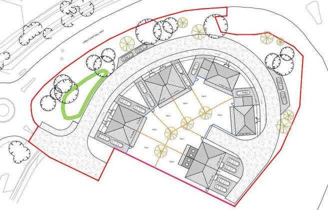
- For the erection of 8 dwellings
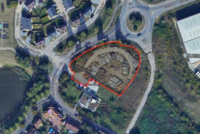
- Site extending in all to some 0.93 acres
Description
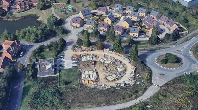
OVERVIEW: This site presents an opportunity to complete a partially developed residential development of 8 units. Outline planning permission was granted under reference 19/500 866/OUT for the erection of up to 9 dwellings, and has since had submission of det ails (23/500765/SUB) and non-material amendment (24.500126/NMAMD) applications approved. The planning has been implemented seeing the installation of foundations for the 8 units as well as initial infrastructure works. A schedule of works to date is available upon request.The site sits in a sustainable location with convenient access to a range of local services and transport links.
LOCATION: The site is located to the east of Great Easthall Way and south of Swale Way. Its northern boundary adjoins Fairlake View, a recently completed residential development delivered in 2022/23. The surrounding area is predominantly residential in character, with established housing located to the west and south of the site, and there is a small cluster of industrial units situated to the east.
METHOD OF SALE: The property is offered for sale via Private Treaty. If demand dictates, the agent may set a deadline for Best and Final Offers in the event that significant interest is received.
ESSENTIAL SITE INFORMATION
HM Land Registry Title Number: K909989
Data Pack: Available on request.
Tenure: Freehold.
Site Size: 0.93 acres/ 0.377 hectares
Services: We request you rely on your own enquiries as to the availability of local service connections.
Local Authority: Swale Borough Council Borough Council, Swale House, East Street, Sittingbourne, Kent, ME10 3HT.
Viewing: The property can be viewed from the road during day light hours. For an accompanied viewing, please contact Will Jex , or Ethan Etheridge . Please contact us prior to a site visit.
Flood Zone: We have searched the Environment Agency’s flood risk data and the site falls in a Flood Zone 1.
To download the full particulars please see the attached links below. Should you wish to have a copy of the brochure posted to you or discuss details further please don't hesitate to contact us on the numbers provided.
Brochures
Full DetailsBrochureLand on the West of Swale Way, Sittingbourne

NEAREST STATIONS
Distances are straight line measurements from the centre of the postcode- Sittingbourne Station1.3 miles
- Kemsley Station1.8 miles
- Teynham Station2.0 miles

About Lambert & Foster Ltd, Paddock Wood
77 Commercial Road, Paddock Wood, Kent, TN12 6DS


Notes
Disclaimer - Property reference 12899973. The information displayed about this property comprises a property advertisement. Rightmove.co.uk makes no warranty as to the accuracy or completeness of the advertisement or any linked or associated information, and Rightmove has no control over the content. This property advertisement does not constitute property particulars. The information is provided and maintained by Lambert & Foster Ltd, Paddock Wood. Please contact the selling agent or developer directly to obtain any information which may be available under the terms of The Energy Performance of Buildings (Certificates and Inspections) (England and Wales) Regulations 2007 or the Home Report if in relation to a residential property in Scotland.