
Retford, Nottinghamshire

- PROPERTY TYPE
Land
- SIZE
3,237,815 sq ft
300,803 sq m
Key features
- 74.34 acres (30.08 hectares)
- Four well-defined parcels
- Grade 3 and 4
- Soils described as loamy and clayey suitable for cereals and productive grassland
- Practical and manageable block for commercial farming
Description
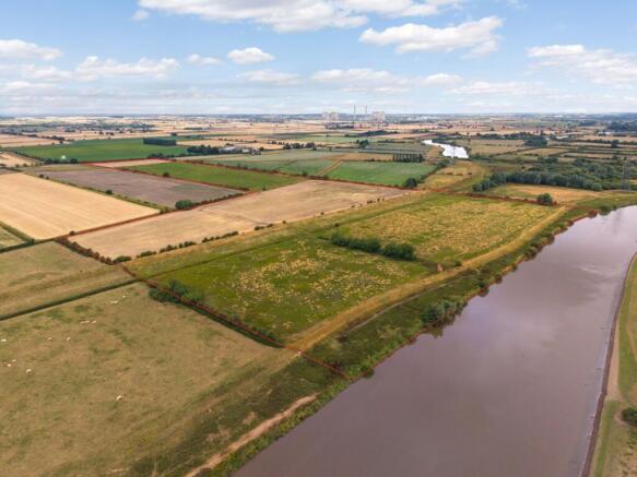
Land at Cottam is situated alongside the River Trent to the north of the village of Cottam and is approximately 8 miles east of Retford.
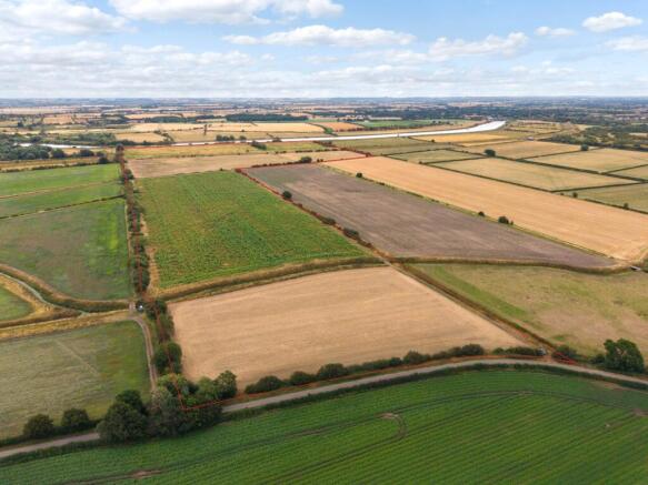
The land extends as a whole to about 74.34 acres (30.08 hectares) and comprises four well-defined parcels, offering a practical and manageable block for commercial farming.
The land is a combination of Grade 3 and Grade 4, with soils described as loamy and clayey floodplain soils with naturally high groundwater, making them suitable for cereals and productive grassland.
Around 46.49 acres is in arable cultivation being a mixture of miscanthus and fallow. The balance is down to pasture and utilised for grazing purposes. The seller would be happy to continue farming the land subject to reaching an agreement with the purchaser.
Land at Cottam offers a versatile and strategically positioned block of land, combining productive capacity with longer-term investment and environmental potential.
Situation
Situated to north of the village of Cottam, near Retford, the land enjoys a rural setting surrounded by open countryside, making it particularly well suited to farming, equestrian and other rural land-based enterprises.
Retford lies approximately 8 miles to the west and despite its rural position, the property benefits from convenient transport connections. The land has road frontage to Headstead Bank that provides access to local villages whilst the A1 is readily accessible, offering efficient road links to the wider towns, cities and regions of Newark, Doncaster, Lincoln and the East of England.
Tenure
The land is to be sold freehold. The grassland is subject to a grazing licence expiring December 2026 at which point vacant possession will be available. The remaining land is to be sold with vacant possession.
Method of sale
The land is offered for sale by private treaty; however, the vendor reserves the right to conclude the sale by an alternative method if required.
Local Authority
Bassetlaw District Council
VAT
The property is not opted to tax for VAT
Public rights of way, wayleaves and easements
The property is sold subject to all rights of way, wayleaves and easements whether or not they are defined in this brochure.
Public footpaths cross the land and are shown on the attached sale plan.
Renewables
There are multiple renewable schemes proposed in the area of which the land forms part and will therefore be sold subject to any existing agreements.
Development Overage
The property will be sold subject to an existing uplift provision being 50% of any increase in value due to development (as defined in Section 55 of the Town and Country Planning Act 1990) will be payable should such development occur within the existing overage period.
Anti Money Laundering Regulations (AML)
In accordance with Anti Money Laundering Regulations, we are required to request forms of identification and carry out due diligence on any parties connected to a successful offer. Should an offer be made on behalf of a business/company, AML due diligence will also be necessary. Proof/source of funding must be supplied, prior to offer acceptance.
Plans and boundaries
The plans within these particulars are based on Ordnance Survey data and provided for reference only. They are believed to be correct but accuracy is not guaranteed. The purchaser shall be deemed to have full knowledge of all boundaries and the extent of ownership. Neither the vendor nor the vendor’s agents will be responsible for defining the boundaries or the ownership thereof.
Viewings
Strictly by appointment through Fisher German LLP
Directions
Postcode – DN22 0EZ
what3words – ///household.skims.quiet
Brochures
ParticularsRetford, Nottinghamshire

NEAREST STATIONS
Distances are straight line measurements from the centre of the postcode- Saxilby Station5.4 miles

About Fisher German, Covering Yorkshire & The Humber
Lakeside Business Park 2 Carolina Court Doncaster PE8 6JR
Notes
Disclaimer - Property reference DON260035. The information displayed about this property comprises a property advertisement. Rightmove.co.uk makes no warranty as to the accuracy or completeness of the advertisement or any linked or associated information, and Rightmove has no control over the content. This property advertisement does not constitute property particulars. The information is provided and maintained by Fisher German, Covering Yorkshire & The Humber. Please contact the selling agent or developer directly to obtain any information which may be available under the terms of The Energy Performance of Buildings (Certificates and Inspections) (England and Wales) Regulations 2007 or the Home Report if in relation to a residential property in Scotland.