
Lot A Lot B Land, Langport, Bristol, TA10

- PROPERTY TYPE
Farm Land
- SIZE
Ask agent
Description
"Flat Agricultural pasture farmland accessed off Litness Drove and Huish Drove, Langport, Somerset, nearest postcode TA10 9HH.
The land has been used for livestock grazing and maybe suitable for a solar farm subject to raising solar panels higher than standard because the ground gets moist in winters & in extreme weather conditions the ground might stay wet for a duration. (Contact Environmental Agency for data).
Any permitted Livestock Agricultural Buildings (subject to local authority consent) may need to be raised above ground level and might require Biodiversity Net Gain ponds dug to contain extreme wet periods & provide natural livestock water to cope with the extreme dry summer periods. (contact Somerset Council).
Grass feeding livestock can graze under solar panels so the Agricultural native function will continue with the added benefit to society of energy security renewable energy cultivation helping UK reach net zero.
The land maybe suitable for all year round Goose farming and Wind Turbines plus solar farm. Sheep farming maybe possible all year round subject to rotation & low sheep numbers. Problem with Cattle is moving cattle off site in extreme wet winter to avoid ground turning muddy. Lot A & Lot B are on similar ground levels to industrial & residential sites nearby however Lot A & B are adjoining & near sluice & river.
Please note there is a Drove bridge weight limit 7.5 tonne. For Viewings there maybe parking at the car park at what3words position: "fiery.nods.worm" (subject to availability).
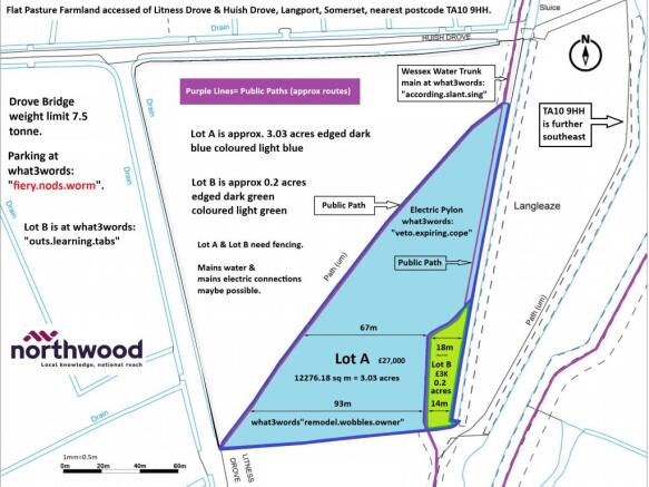
Lot A: Approx 3.03 acres £27,000 what3words position: "veto.expiring.cope". The Eastern boundary adjoins the Sluice up to the Lot B boundary where after it follows the north to south purple public path .
The Lot A Southern boundary is existing hedgerows & trees. The diagonal Northwestern boundary follows the purple public path & requires fencing.
Lot B: Approx 0.2 acres £3000 what3words position: "evaporate.save.viewer".
Lot B max width is approx 18m and maybe suitable for an allotment (subject to local authority consents) or small scale goose farming or can be a small sheep rotation field if bought with Lot A.
The Lot B Eastern boundary adjoins the Sluice. The Southern boundary is existing thin strip of hedgerows & trees plus a gate.
The Lot B North & West boundary follows the public path & requires fencing.
Services: Overhead mains Electricity pylon on site for potential connection for solar & wind cultivation and/or small holding Agriculture (contact National Grid)
Underground mains Water nearby for potential connection (contact Wessex Water). Both Lots benefit from natural water access from the sluice. Drinking ponds could be created (subject to local authority consent).
Sporting rights: Will transfer to the new owner(s) as far as the vendor is aware.
Directions: Drive towards TA10 9HH aiming for the T junction on the main road (the main road is called "The Hill").
The T junction is at the approx what3words position: "lives.grafted.applied" where you exit "The Hill" & drive south along the Bridleway style track.
Drive along Bridleway Style Track along Huish Drove aiming for the car park at approx what3words position "fiery.nods.worm".
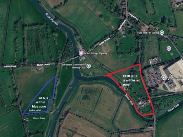
You should be able to park at "fiery.nods.worm" then walk along Huish Drove aiming for Lot A approx what3words position "veto.expiring.cope".
Tenure: Freehold with (potential) Countryside Stewardship and Sustainable Farming Incentive benefits (subject to RPA rules).
Rights of way: Public paths are shown on the map as purple lines; both Lots need fencing to help public navigate via public path routes.
Easements: Water & Electric Easement rights maybe transfered to new owners.
Method of Sale: Private Treaty.
Health and Safety Notice: At own risk, please be respectful of public path walkers and dogs and view at buyers risk observing country code and closing gates.
Measurements: All measurements are approximate using scale plans. Note the google aerial map shows Lot A is not to scale (Lot A is illustrated to help navigation from TA10 9HH to Lot A).
Lot A Lot B Land, Langport, Bristol, TA10

NEAREST STATIONS
Distances are straight line measurements from the centre of the postcode- Bridgwater Station10.1 miles


Notes
Disclaimer - Property reference P2988. The information displayed about this property comprises a property advertisement. Rightmove.co.uk makes no warranty as to the accuracy or completeness of the advertisement or any linked or associated information, and Rightmove has no control over the content. This property advertisement does not constitute property particulars. The information is provided and maintained by Northwood, Warminster. Please contact the selling agent or developer directly to obtain any information which may be available under the terms of The Energy Performance of Buildings (Certificates and Inspections) (England and Wales) Regulations 2007 or the Home Report if in relation to a residential property in Scotland.