Carlton Curlieu, Leicester, LE8

- PROPERTY TYPE
Farm Land
- SIZE
Ask agent
Key features
- An opportunity to acquire a 94.82 acre block of mixed agricultural land
- Multiple direct roadside access
- Freehold with vacant possession
- For sale by informal tender as a whole
- * INFORMAL TENDER DEADLINE 13th NOVEMBER 2026 AT 12 NOON *
Description
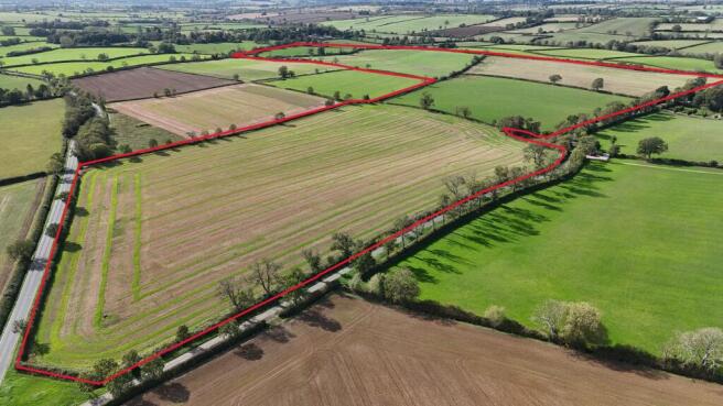
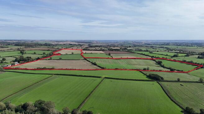
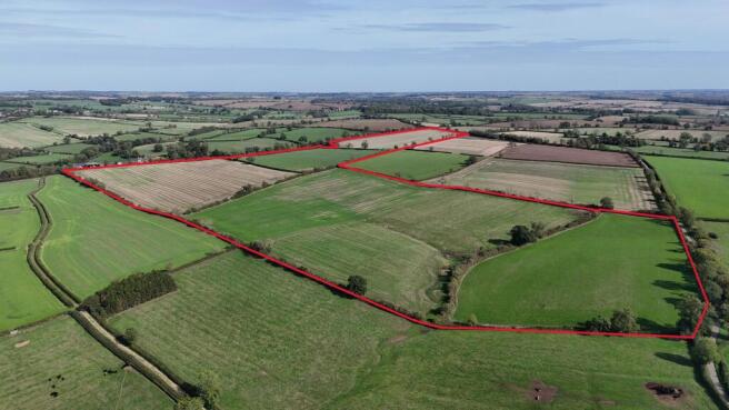
An opportunity to acquire a ring-fenced block of productive mixed agricultural land in South East Leicestershire. The land extends to approximately 94.82 acres (38.37 Hectares), with approximately 55 acres (22.26 Ha) of arable and 39.82 acres (16.11 Ha) of grassland.
The land is divided into six good sized fields, comprising of predominately level land, with some gently undulating permanent pastureland to the southern part of the block. The fields are bounded with mature hedgrows, established trees and some post and wire fencing.
The land is described as being of good heart and benefits from several access points. Roadside access is available at the southern end of the block, directly off Grange Road, with a further roadside access to the north of the block from Gartree Road.
The land is classified as Grade 3 agricultural land and provides an attractive, well maintained block suitable for a range of agricultural uses.
GUIDE PRICE
Offers Around £930,000 (Nine Hundred and Thirty Thousand Pounds)
CROPPING HISTORY
First Wheat - two most north west parcels (approximately 22 and 14 acre fields)
Winter Barley - approximately 19 acre field (furthest north east parcel)
The field parcel furthest to the south is currently in a ryegrass and clover ley.
TENURE
The land is freehold and is offered with vacant possession.
METHOD OF SALE
The land is offered for sale via Informal Tender. A tender form can be obtained from the selling agent. The Vendors arenot obliged to accept the highest or indeed any offer submitted.
Tenders are to be submitted in writing by 12 noon on Friday 13th November 2026 and should include the following information: 1. All offers are to be expressed in pounds sterling 2. Offers should not be made by reference to any other offers 3. Offers should state whether offers are for cash or dependent on borrowing/funding. 4. The vendors and selling agents advise all offers be received via email to the following email address eloise. – a confirmation of receipt will be sent.
FLOOD ZONE
The land is located within Flood Zone 1.
LAND CLASSICATION AND SOIL TYPE
Natural England classifies the land as Grade 3.
Soilscapes classes the land as Soilscape 18: Slowly permeable seasonally wet slightly acid but base-rich loamy and clayey soils.
RIGHTS OF WAY/EASEMENTS AND WAYLEAVES
The land is crossed by a high-pressure gas pipeline. Prospective purchasers should make their own enquiries with the National Grid providing the precise location of the pipeline and any associated easements, wayleaves, restrictions or rights affecting the land.
The land is also crossed by a fibre optic cable, with an associated easement extending approximately 6 metres in width. The cable is understood to be appriximately 1 metre below ground level. General agricultural cultivation which does not penetrate below 300mm is not understood to require supervision, however, works or activities beyond this depth may require prior notification and/or supervision by the relevant utility provider. An indicative plan showing the approximately location of the fibre optic cable and easement is available from the Agents upon request.
The land is sold subject to all rights way, wayleaves and easements whether or not mentioned in this sales particulars.
DRAINAGE
The land is understood to benefit from a network of drainage. A plan of the drainage scheme can be available upon request from the agents.
LAND REGISTRY
The land is registered with the UK Land Registry:
LT517197 - please note the registered title includes a small triangular section of grass verge/trees boardering the adopted Gartree Road (approximately 0.1 ac) that was misregistered and belongs to a neighbouring landowner. This is currently being resolved by the Vendor's solicitors.
SERVICES
The land has a natural spring connected to a water trough in the southern most field parcel. There is no mains water connection.
Any prospective purchasers must satisfy themseleves as to the availability of services and any future connections.
ACCESS
The land can be accessed directly off Grange Road, and Gartree Road.
ANTI-MONEY LAUNDERING REGULATIONS
Due to regulatory requirements, we are legally required to undertake full identification checks on any prospective purchaser prior to proceeding with an agreed sale. These checks are carried out through our online system, Landmark, and include identity verification and facial recognition checks.
A fee of £25 + VAT is payable by each prospective purchaser in respect of these checks.
VAT
In the event that any part of the land is subject to VAT, this will be payable by the purchaser in addition to the purchase price.
DEVELOPMENT UPLIFT CLAUSE
The property will be sold subject to an uplift clause whereby 50% of any increase in value arising from the development or grant of planning permission (excluding uses for agriculture and personal equestrian purposes), will be payable to the vendor for a period of 50 years from completion.
SPORTING, MINERAL & TIMBER RIGHTS
All sporting, mineral and timber rights, where owned, are included within the sale.
LOCAL AUTHORITY
Harborough District Council and Leicestershire Country Council
RATES & OUTGOINGS
The property is sold subject to any other rates and outgoings, which the purchaser will be liable for.
VIEWINGS
Viewing of the land is strictly by appointment only. Please contact the agents for more information.
PLAN
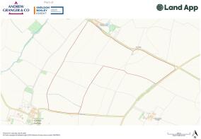
The plan and red lines are for reference purposes only. The Vendor, nor the Vendor's Agent are responsible for defining the boundaries of the ownership.
FURTHER INFORMATION
For further information, or a tender form, please contact Eloise Baker at our Loughborough Rural office.
Eloise Baker BSc (Hons), MSc
TEL:
E-MAIL: eloise.
Brochures
Property BrochureCarlton Curlieu, Leicester, LE8

NEAREST STATIONS
Distances are straight line measurements from the centre of the postcode- South Wigston Station6.7 miles
About Andrew Granger & Co Rural, Land and Development, Loughborough
44-46 Forest Road, Loughborough, LE11 3NP
Notes
Disclaimer - Property reference 6225adaf-884e-4e2a-8a75-aedbb090caec. The information displayed about this property comprises a property advertisement. Rightmove.co.uk makes no warranty as to the accuracy or completeness of the advertisement or any linked or associated information, and Rightmove has no control over the content. This property advertisement does not constitute property particulars. The information is provided and maintained by Andrew Granger & Co Rural, Land and Development, Loughborough. Please contact the selling agent or developer directly to obtain any information which may be available under the terms of The Energy Performance of Buildings (Certificates and Inspections) (England and Wales) Regulations 2007 or the Home Report if in relation to a residential property in Scotland.