Mountain Ash, Cwmpennar, Mountain Ash, CF45
Business rates & charges may apply

- SIZE
Ask agent
- SECTOR
Land for sale
Key features
- FOR SALE BY PRIVATE TREATY
- Approximately 49.12 acres (19.87 ha) of sloping woodland formerly used as a coal tip (Category D)
- Conveniently located close to the A4059
- Suitable for a range of uses including amenity, bio-diversity net gain, environmental or redevelopment subject to planning (STP)
- Tarmacadam track serving the parcel to the west
Description
DESCRIPTION
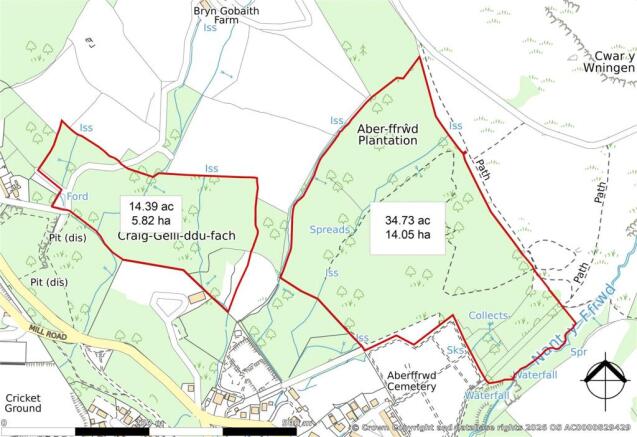
Two blocks of sloping amenity woodland extending in total to approximately 49.12 acres (19.87 hectares), conveniently located to the northwest of Mountain Ash with the land to the west benefiting from an internal tarmacadam access track. Whilst the land was formerly used for coal tipping, it has more recently been regenerated and now comprises woodland designated as Grade D under the coal tip classification system. The property may be suitable for a range of uses including amenity, environmental, biodiversity net gain or potential redevelopment, subject to the necessary planning consents (STP).
SITUATION
The land is situated to the north-west of Mountain Ash (1.2 miles), between Abercynon (3.3 miles) and Aberdare (4.0 miles) and approximately 20 miles north of Cardiff, occupying a semi-rural yet highly accessible position within the County Borough of Rhondda Cynon Taf. The land benefits from good connectivity, with access via the A4109 and convenient links to the A4059 and the A470, which provides a direct route between Cardiff and Merthyr Tydfil. The A465 (Heads of the Valleys Road) is also located approximately 2.1 miles away, which connects to the A40 and Junction 43 of the M4, providing further regional access.
SERVICES
We are not aware of any mains services connected to the land; however, Purchasers are advised to make their own enquiries with the relevant providers for any service connections which may exist in the local vicinity.
ACCESS
Vehicular and pedestrian access to the land to the west is made via the east end of High Row in Cwmpennar, which is connected via Dyffryn Road back to the A4059, the main highway running north-south through the Cynon Valley. The land to the east benefits from a hardcore track via the public footpath, suitable for pedestrian and small vehicular use.
DESIGNATIONS
- Sandstone Resources - Sites of Importance for Nature Conservation - Special Landscape Area - Grade D Coal Tip Purchasers are advised to make their own enquiries as to any additional designations which exist on the land.
TENURE
Freehold with vacant possession upon completion.
BOUNDARIES
The Purchaser shall be deemed to have full knowledge of the boundaries and neither the Vendor nor the Agent should be required to produce evidence as to the ownership of the boundaries.
LOTTING & RESERVE
It is anticipated that the property will be offered as shown but the Vendor reserves the right to withdraw, alter or amend the extent of the property being offered.
EASEMENTS, COVENANTS & RIGHTS OF WAY
There is a public footpath running along the eastern boundary of the eastern parcel (MOU/1/1), together with a further public footpath running along the tarmacadam track adjoining the western block (MOU/34/1). The land is sold subject to and with the benefit of all rights, easements, wayleaves and other incidents of tenure which may affect it including access to Bryn Gobaith.
DIRECTIONS
From Junction 32 of the M4, head north onto the A470 and continue for approximately 10.5 miles. Exit at the Abercynon junction and take the first exit onto the A4059. Continue along the A4059 for approximately 3.8 miles before turning right by Woods Barn & Restaurant. For the western parcel, proceed to the roundabout and take the first exit onto Dyffryn Road, continuing for approximately 0.5 miles. Bear right and then turn right onto High Row. Continue along this road, bearing right where the road divides, where a vehicular and pedestrian access to the land will be visible (refer to Photo 3). For the eastern parcel, after turning by Woods Barn & Restaurant, take the first exit onto Dyffryn Road and continue for approximately 0.1 miles before turning sharply right onto Aberffrwd Road. Follow this road for approximately 0.3 miles until reaching the cemetery. A public footpath providing access to the land will be located on the right-hand side (refer to Photo 4). When using (truncated)
VIEWING
At any reasonable daylight hour with a set of sales particulars to hand and with the usual courtesy shown to the owner/occupier. Please contact David James’ Magor Office in advance to inform them and register your interest on .
GUIDE PRICE
Offers in Excess of £125,000 (One Hundred and Twenty-Five Thousand Pounds).
LOCAL AUTHORITY
Rhondda Cynon Taf Council.
Brochures
Mountain Ash, Cwmpennar, Mountain Ash, CF45

NEAREST STATIONS
Distances are straight line measurements from the centre of the postcode- Fernhill Station0.6 miles
- Mountain Ash Station0.7 miles
- Cwnbach Station1.5 miles
Notes
Disclaimer - Property reference MAG260074. The information displayed about this property comprises a property advertisement. Rightmove.co.uk makes no warranty as to the accuracy or completeness of the advertisement or any linked or associated information, and Rightmove has no control over the content. This property advertisement does not constitute property particulars. The information is provided and maintained by David James, Magor. Please contact the selling agent or developer directly to obtain any information which may be available under the terms of The Energy Performance of Buildings (Certificates and Inspections) (England and Wales) Regulations 2007 or the Home Report if in relation to a residential property in Scotland.