Moortown, High Ercall, Telford
- PROPERTY TYPE
Land
- SIZE
Ask agent
Key features
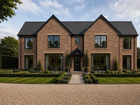
- PIP for Single Modern Detached Dwelling & Garage
- Open Shropshire Countryside Views
- Suitable for Self-Builders & Investors Alike
- Easy Access to Wider Road Network
- Sought-After Village Location
- Set within Approx. 1.29 Acres (0.52 ha)
Description
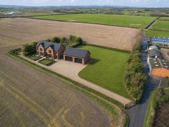
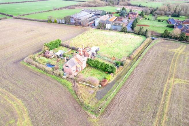
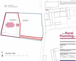
Situation: This unique site, suitable for self-builders and developer alike, benefits from some existing services, its own access track, a level site for the erection of a detached dwelling and garage and an adjacent paddock, all extending to approx. 1.29 acres (0.52 ha).
The site enjoys close to 360 degrees of open country views of the stunning Shropshire rural landscape.
The development site is situated just north of the B5062, which connects the villages of High Ercall and Crudgington, and approximately 9 miles to the centre of Telford to its South and 9 miles to Shrewsbury to its South West. Although the site is located outside of development boundaries, with none in close proximity, PIP has been given consent due to the existing properties on site. High Ercall is identified as a high-ranking settlement in terms of infrastructure within the Telford and Wrekin Local Plan. The village has a village hall, shop, church, primary school and village tennis club. Until recently it also had a public house. The number 104 and 521 bus operates on the B5062 past the end of the lane providing access to this settlement.
The purchaser will be responsible for progressing the relevant and appropriate documentation and works required in order to deliver the site in accordance to Telford and Wrekin’s planning guidelines. This will include:
- Design and Access Statement
- Climate Change Checklist, Scheme of foul drainage, and surface water drainage
- SuDS Proforma
- Biodiversity Net Gain Assessment
- Bat Survey
Services: Water: private bore hole. Mains electricity. Septic tank drainage.
Council Tax: To be assessed on completion of build.
Postcode: TF6 6JE
Local Authority: Telford & Wrekin Council )
Mobile Signal: EE Y Three Y O2 Y Vodafone Y
Broadband Speed: Please conduct your own research to ensure the speeds meet your requirements.
Flood Risk: Rivers and Sea and Surface Water - Very low risk.
Wayleaves, Easements and Rights of Way: There is a public right of way bordering onto the east side of the paddock. The property will be sold subject to and with the benefit of all wayleaves, easements and rights of way, whether mentioned in these particulars or not.
Please Note: The current bore hole is owned by The Firs, Moortown Due to its age and recent changes in regulations, a purchaser will be required to drill a new bore hole. A detailed hydroecological survey has been completed for the site, showing an abundant supply of water. There is also a detailed budgetary quotation available. A Planning pack can be requested via the agent.
Directions: At the Battlefield Roundabout, take the A53 exit. Continue on the A53 for 4.4 miles then turn right onto Wytheford Road/B5063. Continue for 3.9 miles then at the roundabout, take the 1st exit onto Cotwall Ln/B5062. Continue for 1 mile, then turn left, signposted ‘Moortown’. Continue down the lane and the site will be around 0.4 miles down on your left.
what3words: ///books.ejects.dissolves
Brochures
ParticularsMoortown, High Ercall, Telford

NEAREST STATIONS
Distances are straight line measurements from the centre of the postcode- Wellington Station4.9 miles
- Oakengates Station7.1 miles


Notes
Disclaimer - Property reference SBY230072. The information displayed about this property comprises a property advertisement. Rightmove.co.uk makes no warranty as to the accuracy or completeness of the advertisement or any linked or associated information, and Rightmove has no control over the content. This property advertisement does not constitute property particulars. The information is provided and maintained by Balfours LLP, Shrewsbury. Please contact the selling agent or developer directly to obtain any information which may be available under the terms of The Energy Performance of Buildings (Certificates and Inspections) (England and Wales) Regulations 2007 or the Home Report if in relation to a residential property in Scotland.