

Land off Cliff Lane, Acton Bridge, Northwich
- PROPERTY TYPE
Land
- SIZE
Ask agent
Key features
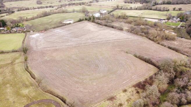
- Grade 3 agricultural land totalling 14.65 acres
- Suitable for agricultural or equestrian use
- Mains water supply
Description
Land off Cliff Lane, Creewood Common, Northwich
SUMMARY
A parcel of grade 3 agricultural land totalling 14.65 acres (5.93 ha) with mains water supply. The land has been rented out and used for arable cropping in previous years. The land would be well suited to agricultural or equestrian purchasers.
DIRECTIONS
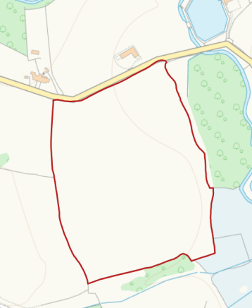
From Crowton village follow Kingsley Road (B5153) towards Kingsley, and then turn right onto Creewood Common Road. Continue for approximately 1 mile, keeping left at the triangle and then take the first right onto Cliff Lane. The land is situated approximately 0.10 mile along the lane indicated with a Rostons sale board.
VIEWINGS
The land can be viewed at any reasonable time without prior appointment with the selling agent. We request that you take a copy of these sales details with you when viewing the land.
BASIC PAYMENT SCHEME (BPS)
For the avoidance of doubt the land is sold without Basic Payment Scheme Entitlements or de-linked payments.
TENURE & TITLE
Freehold with vacant possession.
Guide Price: Offers in the region of £150,000
OVERAGE
The land will be sold with no overage.
SERVICES
Mains water supply.
SOIL TYPE LAND GRADE
According to the Cranfield Soil and Agri-food Institute (Soilscapes of England & Wales), the soil is classed as "Soilscape 18" described as slowly permeable seasonally wet slightly acid but base-rich loamy and clayey soils. The land is Grade 3 (Land Classification Series for England & Wales) (Grade 1 - best, Grade 5 - worst).
FENCING
The boundaries will be the responsibility of the purchaser.
TOWN AND COUNTRY PLANNING ACT
The property not withstanding any description contained in these particulars, is sold subject to any development plan, tree preservation order, town planning scheme or agreement, resolution or notice.
SALE PLAN AND PARTICULARS
The sale plan is based on the Ordnance Survey sheet. Prospective purchasers should check the contract documents. The purchasers shall raise no objection or query in respect of any variation between the physical boundaries and the Ordnance Survey sheet plan. The plans are strictly for
identification purposes only.
MONEY LAUNDERING LEGISLATION
Rostons Ltd must comply with Anti Money Laundering legislation. As part of the requirements, Rostons must obtain evidence of the identity & proof of address of potential buyers. Prior to an offer being accepted, all parties who are purchasing must provide the evidence.
EASEMENTS, WAYLEAVES AND RIGHTS OF WAY
The land is sold subject to and with the benefit of all public and private rights of way, lights, drainage, cable, pylons or other easements, restrictions or obligations whether or not the same are described in these particulars of sale.
ACCESS
Access via the gateway on Cliff Lane.
SELLING AGENTS
Alice Kearns
Rostons Ltd
West View House
Hatton Heath
Chester
CH3 9AU
VENDORS SOLICITORS
Rebecca Skelly
Mosshaselhurst Solicitors
2 Castle Street
NORTHWICH
Cheshire
CW8 1AB
Brochures
Sales DetailsLand off Cliff Lane, Acton Bridge, Northwich

NEAREST STATIONS
Distances are straight line measurements from the centre of the postcode- Acton Bridge Station1.5 miles
- Cuddington Station3.0 miles
- Hartford Station4.2 miles

About Rostons, Hatton Heath
West View House Whitchurch Road, Hatton Heath, CH3 9AU
Notes
Disclaimer - Property reference CP16239. The information displayed about this property comprises a property advertisement. Rightmove.co.uk makes no warranty as to the accuracy or completeness of the advertisement or any linked or associated information, and Rightmove has no control over the content. This property advertisement does not constitute property particulars. The information is provided and maintained by Rostons, Hatton Heath. Please contact the selling agent or developer directly to obtain any information which may be available under the terms of The Energy Performance of Buildings (Certificates and Inspections) (England and Wales) Regulations 2007 or the Home Report if in relation to a residential property in Scotland.