
Whole - Dipwell Farm, Ashburton
- PROPERTY TYPE
Farm House
- BEDROOMS
4
- BATHROOMS
1
- SIZE
2,402 sq ft
223 sq m
- TENUREDescribes how you own a property. There are different types of tenure - freehold, leasehold, and commonhold.Read more about tenure in our glossary page.
Freehold
Key features
- Approximately 100.18 acres in all
- Range of traditional stone barns (4,518 sq ft over two floors) within a courtyard with potential for development (STP)
- Modern Farm Buildings (6,825 sq ft) with further potential for development (STP)
- Farmhouse (Grade II listed) requiring renovation works
- Separate character Cottage ideal for development
- Conveniently located close to A38 dual carriageway expressway
- First time to the market in over 100 years
- Available for sale as whole or in up to 8 lots subject to purchasers’ requirements.
Description
DIRECTIONS
Heading southbound on the A38 from Exeter towards Plymouth, take the unmarked exit onto Whistley Hill - just after the Ashburton exit and before Pear Tree. Continue up Whistley Hill for 0.5 miles, then turn left at Whistley Hill junction. Drive straight for 0.3 miles; the entrance driveway to Dipwell Farm will be on the right.
Heading northbound on the A38 from Plymouth towards Exeter, take the second Ashburton exit. At the end of the slip road, turn right onto the B3352 and continue across the flyover to rejoin the A38 heading back towards Plymouth. Then take the unmarked exit onto Whistley Hill — just after the Ashburton exit and before Pear Tree. Continue up Whistley Hill for 0.5 miles, turn left at Whistley Hill junction, and follow the road for 0.3 miles. The entrance driveway to Dipwell Farm will be found on the right.
What3Words Location:- neckline.landed.tester
SITUATION
Dipwell Farm is situated on the edge of the small hamlet of Woodland, conveniently located within close proximity to the nearest town of Ashburton in the South Hams area of South Devon.
The A38 dual carriageway expressway, (connecting to the M5 motorway and national road network) is conveniently located about 0.8 miles to the west providing excellent transport links.
Ashburton is conveniently located approximately 1 mile to the west, a vibrant, rural Devon town recently identified in The Times as one of the most desirable UK locations to live in.
DESCRIPTION
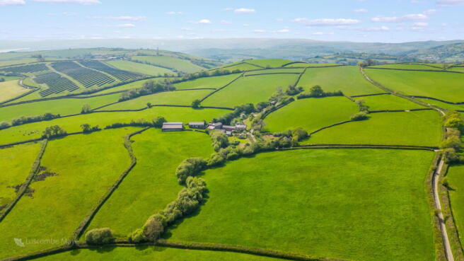
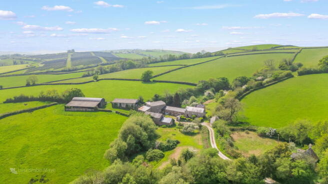
Dipwell Farm comprises a detached Grade II listed farmhouse, a separate character cottage, range of traditional stone outbuildings, general-purpose modern farm buildings and productive agricultural land extending to approximately 100.18 acres (40.54 hectares) in all.
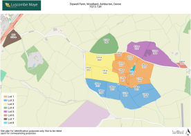
By reference to the site plan, the farm is available for sale as a whole or in a combination of lots to suit purchasers’ requirements.
Dealing with the lots in turn :-
LOT 1 – Dipwell Farmhouse, range of traditional stone barns, modern farm buildings and approximately 23.43 acres in all (outlined orange on the site plan)
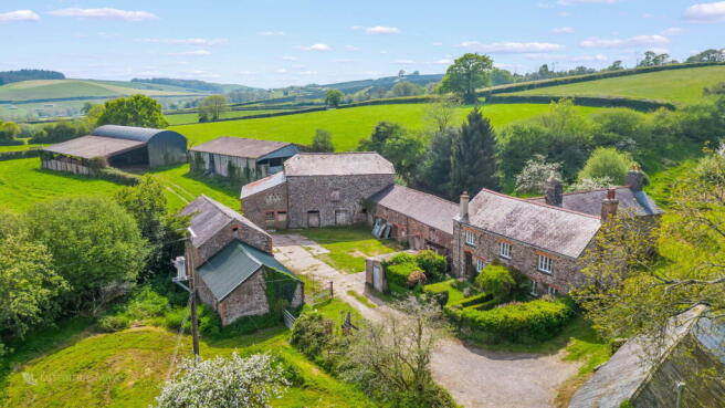
Dipwell Farmhouse
(Grade II listed – Listing number 1249835)
A charming, detached period dwelling believed to date back to the late 16th or early 17th century, with a later 19th century addition. The farmhouse is rich in character being its first time to market in over 100 years. Constructed of traditional stone and red brick beneath a slate roof.
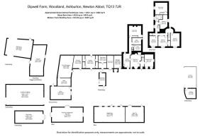
By reference to the below floorplan, Dipwell Farmhouse extends over two floors to a total of approximately 2,402 sq. ft (223.10 sq. m). The accommodation can be summarised as follows: -
Ground Floor
Entrance Hall/Kitchen; Dairy Room; Pantry Room; Former Kitchen; Storage Room above; Sitting/ Dining Room; Reception Room
First Floor
Four bedrooms and family bathroom
Outside
A private driveway leads to the property, with a yard area to the east providing ample parking. To the east and west of the house are two attractive traditional orchards.
A detached stone carport & storage building lies to the north of the farmhouse – extending to 548 sq. ft (51 sq. m).
Services (Dipwell Farmhouse)
Well water supply, mains electric, and shared private septic tank drainage. Raeburn for domestic hot water.
Private Drainage
Please note that the septic tank is currently shared with Dipwell Cottage and is estimated to be approximately 50–60 years old. It will be the responsibility of the purchasers of the respective lots to upgrade or replace with their own system in accordance with current regulations.
Stone Barns
Located immediately to the south and within close proximity of the farmhouse arranged in a charming courtyard. Extending to a total net internal floor area of approximately 4,518 sq. ft (419.6 sq. m) over a number of floors. The barns are predominantly of a solid stone construction under a combination of slate and corrugated tin roofs.
The stone barns do not have planning consent for change of use to residential but offer the potential for such change of use for a prospective purchaser. These stone barns and all further outbuildings available may be summarised by reference to the floorplan below.
Modern Farm Buildings
The range of modern farm buildings are located immediately to the south of the traditional stone barns and extend to a total of some 6,825 sq. ft (634 sq. m) in all. Brief descriptions of which are as follows :-
1. Livestock Building - 60’ x 45’ (2,700 sq. ft)
Steel frame construction with concrete blockwork walls with yorkshire boarding cladding, under a fibre cement roof. Combination of concrete and earth floor.
2. Dutch Barn - 75’ x 25’ (1,875 sq. ft) & lean to – 75’ x 30’ (2,250 sq. ft)
Steel frame construction with tin cladding under a tin roof.
Services (Stone & Modern Farm Buildings)
Shared services with Dipwell Farmhouse as above.
Note – The contents of the Stone Barns and Modern Farm Buildings, as listed above, are sold as seen.
The Lands
The land wraps around the farmstead providing a significant amount of protection, a schedule of the land is set out below :-
Field Number Acres Description
SX7669 8943 1.47 Permanent Pasture
SX7769 0140 3.21 Permanent Pasture
SX7669 9133 4.26 Permanent Pasture
SX7669 8926 1.39 Orchard
SX7669 9410 1.24 Permanent Pasture
SX7769 0720 3.66 Permanent Pasture
SX7769 0226 0.55 Orchard
SX7769 1332 6.50 Permanent Pasture
House/ Yard/ Buildings 1.06 -
Total 23.43 (9.48 ha)
LOT 2 – 28.34 acres (11.47 hectares) of bare agricultural land (highlighted blue on the site plan)
Located to the south of the farmstead is a total of some 28.34 acres (11.47 hectares) of primarily permanent pasture land with a small area of woodland.
The land is fully enclosed with stock fencing along all boundaries and is predominantly of a gentle south facing gradient. Most recently used for livestock grazing, the land has also been used in the past for cropping purposes.
Access is available via a single vehicular width gateway situated on the western boundary, directly off a council maintained highway.
This lot is served by a separate well water supply.
Note - In the event the farm is sold in separate lots, the vendor will install a stockproof fence within 6 weeks following legal completion between points A - B marked on the site plan, in field parcel SX7669 9410.
Field Number Acres Description
SX7769 0812 4.44 Permanent Pasture
SX7769 1404 7.04 Permanent Pasture
SX7669 9410 6.22 Permanent Pasture
SX7669 8210 4.86 Permanent Pasture
SX7669 6715 5.34 Permanent Pasture
SX7669 7206 0.44 Woodland
Total 28.34 (11.47 ha)
LOT 3 – 18.26 acres (7.39 hectares) of bare agricultural land (highlighted in yellow on the site plan)
Located to the west of the farmstead, this lot extends to a total of some 18.26 acres (7.39 hectares) of permanent pasture. This land offers the potential for arable cropping purposes and has been used for that purpose in the past.
The land is fully enclosed with stock fencing along the boundaries and is predominantly of a gentle south facing gradient.
Access is gained via three separate single vehicular width gateways, two on the western boundary and a third on the northern boundary.
This lot is currently served by a well/mains water supply. See water supply paragraph below.
Field Number Acres Description
SX7669 6940 8.34 Permanent Pasture
SX7669 5929 2.03 Permanent Pasture
SX7669 7426 7.89 Permanent Pasture
Total 18.26 (7.39 ha)
LOT 4 – 9.10 acres (3.68 hectares) of bare agricultural land (highlighted in green on the site plan)
Located on the northern side of Whistley Hill, this lot extends to a total of some 9.10 acres (3.68 hectares) of permanent pasture.
The land has been used for livestock grazing in the past and is fully enclosed with stock fencing along all boundaries and is predominantly of a gentle east facing gradient.
Access is gained via a single vehicular width gateway on the southern boundary, directly off the council maintained highway.
The land benefits from a mains water supply, serving a water trough located on the southern boundary. See water supply paragraph below.
Field Number Acres Description
SX7669 7554 9.10 Permanent Pasture
Total (3.68 ha)
LOT 5 – 15.89 acres (6.43 hectares) of bare agricultural land (highlighted in purple on the site plan)
Located on the northern side of Whistley Hill, this lot extends to a total of some 15.89 acres (6.43 hectares) of permanent pasture with an area of copse.
The land has been used for livestock grazing and is fully enclosed with stock fencing along all boundaries. The land is a combination of gentle and moderate north and east facing gradients.
Access is gained via a single vehicular width gateway on the southern boundary, directly off the council-maintained highway.
The land benefits from a natural stream water supply on the northern boundary.
Field Number Acres Description
SX7769 0751 6.11 Permanent Pasture
SX7769 2643 9.04 Permanent Pasture
Pt SX7769 2643 0.74 Former quarry/wood
Total 15.89
(6.43 ha)
LOT 6 – 0.84 acres (0.34 hectares) of bare amenity land (highlighted in red on the site plan)
Extending to some 0.84 acres (0.34 hectares) in all.
Predominantly of a gentle north eastern facing gradient, the land would be particularly suited for general recreation/amenity or other uses (subject to obtaining the necessary planning consents).
The land is accessed via a right of way off the council maintained highway via a single vehicular width gateway.
The land benefits from a natural stream water supply on the northern boundary.
Field Number Acres Description
SX7769 5035 0.84 Permanent Pasture
Total (0.34 ha)
LOT 7 – 3.76 acres (1.52 hectares) of bare agricultural land (highlighted in brown on the site plan)
Located to the west of the farmstead, the land extends in all to approximately 3.76 acres (1.52 hectares) of permanent pasture land.
Predominantly of a moderate south and west facing gradient, the land would be particularly suited to general recreation/amenity or other uses (subject to obtaining the necessary planning consents).
Access is gained via two separate single vehicular width gateways, one on the northern boundary and a second on the eastern boundary.
There is a separate mains water supply to this land.
Field Number Acres Description
SX7569 8561 3.76 Permanent Pasture
Total (1.52 ha)
LOT 8 – Dipwell Cottage, car port & approx. 0.56 acres (0.23 hectares) of garden (highlighted turquoise on the site plan)
A character detached cottage of rendered stone construction under a slate roof with large garden area.
The property requires refurbishment but offers a prime opportunity to create a charming and idyllic rural home.
By reference to the floorplan Dipwell Cottage extends to a total of approximately 967 sq. ft (89.8 sq. m) over two floors and the accommodation can be summarised as follows: -
Ground Floor
Living room, Kitchen & Bathroom
First Floor
Two Bedrooms
Outside
A large garden area extending to approx. 0.56 acres (0.23 hectares) surrounds the cottage allowing for suitable extension (subject to obtaining the necessary planning consents).
Dipwell Cottage benefits from a basic carport/ general purpose building constructed of a timber frame and tin clad construction under a tin roof with a concrete floor extending to 47 sq. ft (4.3 sq. m).
EPC Rating (Dipwell Cottage)
Dipwell Cottage currently holds an EPC rating of F, with potential to be improved to a C.
Services (Dipwell Cottage)
Shared well water supply, separate mains electric supply & shared private septic tank drainage. See private drainage paragraph above and water supply paragraph below.
Note - In the event the farm is sold in separate lots, the vendor will install a stockproof fence within 6 weeks following legal completion between points C - D marked on the site plan, in field parcel SX7669 0140.
PUBLIC FOOTPATHS
There is a public footpath (Ashburton FP 11) which proceeds through the northern corner of field parcel SX7569 8561 (Lot 7).
TENURE
The property is held on a freehold basis with vacant possession being available on legal completion.
WATER SUPPLY
In the event the farm is sold in separate lots, the purchaser of Lot 1 (highlighted orange) will be required to install the relevant sub meter(s) to service Lots 3 and 4 respectively at convenient locations within 8 weeks following legal completion. All appropriate rights will be reserved for the relevant parties to access the water supply pipes, meters and associated equipment.
Alternatively, at the discretion of the Vendor Lots 3 and 4 will make their own direct connection to the mains in the highway and disconnect from their existing supplies.
Lot 8 will continue to receive a private water supply from the Well in Lot 1 but will also be granted rights to lay a water supply pipe over Lot 1 to make a direct connection to the water main in the highway along a route which is acceptable to Lot 1. If such direct connection to the mains is made, then Lot 8 will disconnect from the Well supply.
ENVIROMENTAL STEWARDSHIP SCHEME AGREEMENTS
Dipwell Farm is not subject to any Environmental Stewardship Scheme agreements as far as known.
SPORTING AND MINERAL RIGHTS
All sporting and mineral rights are included in the sale, as far as are known.
GUIDE PRICES
Lot 1 Farmhouse, outbuildings and 22.49 acres £925,000
Lot 2 22.48 acres of bare land £250,000
Lot 3 18.26 acres of bare land £185,000
Lot 4 9.10 acres of bare land £ 95,000
Lot 5 15.98 acres of bare land £150,000
Lot 6 0.84 acres of bare land £ 25,000
Lot 7 3.76 acres of bare land £ 45,000
Lot 8 Dipwell Cottage & car port £275,000
The Whole £1,950,000
METHOD OF SALE
The property is being offered for sale by Informal Tender (unless sold prior), such that purchasers’ are invited to submit their highest and final offers in a sealed envelope by Monday 14th July 2025 at 12 noon. Tender forms are available on request from the Sole Selling Agent.
All tenders must be submitted to either 6 Fore Street, South Brent, TQ10 9BQ or 62 Fore Street, Kingsbridge TQ7 1PP in an envelope clearly marked ‘Dipwell Farm’.
The seller does not undertake to accept the highest or any of the offers and the seller reserves the right to withdraw, alter or amend the way in which the land is offered for sale.
Buyer(s) will be required to exchange contracts within eight weeks of their solicitor receiving a draft contract.
LOCAL AUTHORITY
Teignbridge District Council, Forde House, Brunel Rd, Newton Abbot TQ12 4XX. Tel:
VIEWINGS
Strictly by appointment with the Sole Selling Agents, Luscombe Maye of 6 Fore Street, South Brent, TQ10 9BQ. Telephone for details.
HEALTH & SAFETY
Any prospective purchasers of whom would like to view the property & land do so at their own risk. The vendors nor their selling agent accept any responsibility in any incident or accident that may happen.
Brochures
Brochure 1- COUNCIL TAXA payment made to your local authority in order to pay for local services like schools, libraries, and refuse collection. The amount you pay depends on the value of the property.Read more about council Tax in our glossary page.
- Band: E
- LISTED PROPERTYA property designated as being of architectural or historical interest, with additional obligations imposed upon the owner.Read more about listed properties in our glossary page.
- Listed
- PARKINGDetails of how and where vehicles can be parked, and any associated costs.Read more about parking in our glossary page.
- Allocated
- GARDENA property has access to an outdoor space, which could be private or shared.
- Private garden
- ACCESSIBILITYHow a property has been adapted to meet the needs of vulnerable or disabled individuals.Read more about accessibility in our glossary page.
- Ask agent
Energy performance certificate - ask agent
Whole - Dipwell Farm, Ashburton

Add an important place to see how long it'd take to get there from our property listings.
__mins driving to your place
Get an instant, personalised result:
- Show sellers you’re serious
- Secure viewings faster with agents
- No impact on your credit score

Your mortgage
Notes
Staying secure when looking for property
Ensure you're up to date with our latest advice on how to avoid fraud or scams when looking for property online.
Visit our security centre to find out moreDisclaimer - Property reference S1329538. The information displayed about this property comprises a property advertisement. Rightmove.co.uk makes no warranty as to the accuracy or completeness of the advertisement or any linked or associated information, and Rightmove has no control over the content. This property advertisement does not constitute property particulars. The information is provided and maintained by Luscombe Maye Farms & Land, Kingsbridge. Please contact the selling agent or developer directly to obtain any information which may be available under the terms of The Energy Performance of Buildings (Certificates and Inspections) (England and Wales) Regulations 2007 or the Home Report if in relation to a residential property in Scotland.
*This is the average speed from the provider with the fastest broadband package available at this postcode. The average speed displayed is based on the download speeds of at least 50% of customers at peak time (8pm to 10pm). Fibre/cable services at the postcode are subject to availability and may differ between properties within a postcode. Speeds can be affected by a range of technical and environmental factors. The speed at the property may be lower than that listed above. You can check the estimated speed and confirm availability to a property prior to purchasing on the broadband provider's website. Providers may increase charges. The information is provided and maintained by Decision Technologies Limited. **This is indicative only and based on a 2-person household with multiple devices and simultaneous usage. Broadband performance is affected by multiple factors including number of occupants and devices, simultaneous usage, router range etc. For more information speak to your broadband provider.
Map data ©OpenStreetMap contributors.