
LOT 3 - Dipwell Farm, Ashburton
- PROPERTY TYPE
Land
- SIZE
795,406 sq ft
73,896 sq m
Key features
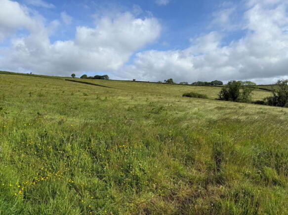
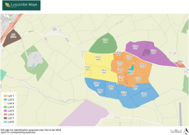
- Approximately 18.26 acres (7.39 hectares) of bare agricultural land as highlighted yellow on the site plan
- Fully enclosed with stock fencing along the boundaries
- Prime agricultural land which offers the potential for arable cropping purposes
- Accessed via three separate single vehicular width gateways
- This lot is served by a well/mains water supply.
- Conveniently located close to A38 dual carriageway expressway
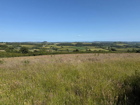
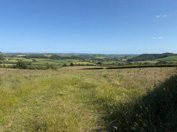
- Predominantly gently sloping
- Available for sale as whole or in up to 8 lots subject to purchasers’ requirements.
Description
DIRECTIONS
Heading southbound on the A38 from Exeter towards Plymouth, take the unmarked exit onto Whistley Hill - just after the Ashburton exit and before Pear Tree. Continue up Whistley Hill for 0.5 miles and the gateway to the land will be found on the left.
Heading northbound on the A38 from Plymouth towards Exeter, take the second Ashburton exit. At the end of the slip road, turn right onto the B3352 and continue across the flyover to rejoin the A38 heading back towards Plymouth. Then take the unmarked exit onto Whistley Hill — just after the Ashburton exit and before Pear Tree. Continue up Whistley Hill for 0.5 miles and the gateway to the land will be found on the left.
What3Words Location:- cakewalk.faces.retraced
SITUATION
Dipwell Farm is situated on the edge of the small hamlet of Woodland, conveniently located within close proximity to the nearest town of Ashburton in the South Hams area of South Devon.
The A38 dual carriageway expressway, (connecting to the M5 motorway and national road network) is conveniently located about 0.8 miles to the west providing excellent transport links.
Ashburton is conveniently located approximately 1 mile to the west, a vibrant, rural Devon town recently identified in The Times as one of the most desirable UK locations to live in.
DESCRIPTION
LOT 3 – 18.26 acres (7.39 hectares) of bare agricultural land (highlighted in yellow on the site plan)
Located to the west of the farmstead, this lot extends to a total of some 18.26 acres (7.39 hectares) of permanent pasture. This land offers the potential for arable cropping purposes and has been used for that purpose in the past.
The land is fully enclosed with stock fencing along the boundaries and is predominantly of a gentle south facing gradient.
Access is gained via three separate single vehicular width gateways, two on the western boundary and a third on the northern boundary.
This lot is currently served by a well/mains water supply. See water supply paragraph below.
Field Number Acres Description
SX7669 6940 8.34 Permanent Pasture
SX7669 5929 2.03 Permanent Pasture
SX7669 7426 7.89 Permanent Pasture
Total 18.26 (7.39 ha)
TENURE
The property is held on a freehold basis with vacant possession being available on legal completion.
WATER SUPPLY
In the event the farm is sold in separate lots, the purchaser of Lot 1 (highlighted orange) will be required to install the relevant sub meter(s) to service Lots 3 and 4 respectively at convenient locations within 8 weeks following legal completion. All appropriate rights will be reserved for the relevant parties to access the water supply pipes, meters and associated equipment.
Alternatively, at the discretion of the Vendor Lots 3 and 4 will make their own direct connection to the mains in the highway and disconnect from their existing supplies.
Lot 8 will continue to receive a private water supply from the Well in Lot 1 but will also be granted rights to lay a water supply pipe over Lot 1 to make a direct connection to the water main in the highway along a route which is acceptable to Lot 1. If such direct connection to the mains is made, then Lot 8 will disconnect from the Well supply.
ENVIROMENTAL STEWARDSHIP SCHEME AGREEMENTS
Dipwell Farm is not subject to any Environmental Stewardship Scheme agreements as far as known.
SPORTING AND MINERAL RIGHTS
All sporting and mineral rights are included in the sale, as far as are known.
GUIDE PRICE
£185,000 (Lot 3)
METHOD OF SALE
The property is being offered for sale by Informal Tender (unless sold prior), such that purchasers’ are invited to submit their highest and final offers in a sealed envelope by Monday 14th July 2025 at 12 noon. Tender forms are available on request from the Sole Selling Agent.
All tenders must be submitted to either 6 Fore Street, South Brent, TQ10 9BQ or 62 Fore Street, Kingsbridge TQ7 1PP in an envelope clearly marked ‘Dipwell Farm’.
The seller does not undertake to accept the highest or any of the offers and the seller reserves the right to withdraw, alter or amend the way in which the land is offered for sale.
Buyer(s) will be required to exchange contracts within eight weeks of their solicitor receiving a draft contract.
LOCAL AUTHORITY
Teignbridge District Council, Forde House, Brunel Rd, Newton Abbot TQ12 4XX. Tel:
VIEWINGS
Strictly by appointment with the Sole Selling Agents, Luscombe Maye of 6 Fore Street, South Brent, TQ10 9BQ. Telephone for details.
HEALTH & SAFETY
Any prospective purchasers of whom would like to view the property & land do so at their own risk. The vendors nor their selling agent accept any responsibility in any incident or accident that may happen.
Brochures
Brochure 1LOT 3 - Dipwell Farm, Ashburton

NEAREST STATIONS
Distances are straight line measurements from the centre of the postcode- Totnes Station5.6 miles

Notes
Disclaimer - Property reference S1329587. The information displayed about this property comprises a property advertisement. Rightmove.co.uk makes no warranty as to the accuracy or completeness of the advertisement or any linked or associated information, and Rightmove has no control over the content. This property advertisement does not constitute property particulars. The information is provided and maintained by Luscombe Maye Farms & Land, Kingsbridge. Please contact the selling agent or developer directly to obtain any information which may be available under the terms of The Energy Performance of Buildings (Certificates and Inspections) (England and Wales) Regulations 2007 or the Home Report if in relation to a residential property in Scotland.
Map data ©OpenStreetMap contributors.