
Off Fosse Way, Cotgrave, Nottingham
- PROPERTY TYPE
Land
- SIZE
2,262,942 sq ft
210,234 sq m
Key features
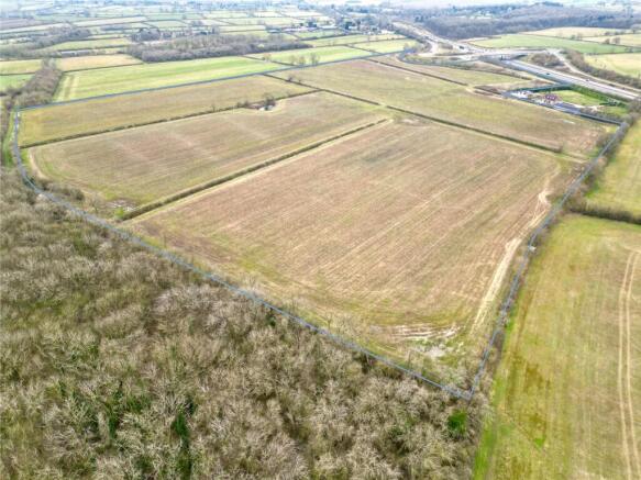
- 51.95 Acre (21.02 Hectare) Block of Arable Land
- Classified Grade III
- Freehold with Vacant Possession
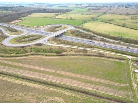
- Strategic Position off the A46 Kinoulton Roundabout
- Long Term Potential Subject to Obtaining the Relevant Consent(s)
Description
Location
The Land
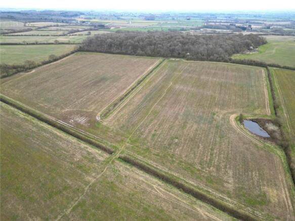
The 51.95 acres (21.02 hectares) ring fenced block of arable land is classified Grade III according to the Agricultural Land Classification Plans of England and Wales. The soil type is of the Denchworth Soil Association described as clayey soils with similar fine loamy over clayey soils. The five parcels of land have been farmed in an arable rotation for a number of years and will be sown in spring 2025 with a legume fallow under the Sustainable Farming Incentive. The land is strategically located off the A46 Kinoulton Roundabout offering excellent connectivity and the potential of long term development subject to obtaining the relevant consent(s).
Method of Sale
The land is for sale by private treaty with Offers in Excess of £500,000.
Services
The land does not benefit from any mains services, both a water and electricity connection would be available in the vicinity.
Land Registry Title Number
The land is registered under title number NT508370. The access road off the Kinoulton roundabout is also included within the sale and registered under title number NT540637. This title grants a right of way to three adjoining landowners.
De-Linked Payments & Environmental Stewardship
The Vendor will retain all de-Linked Basic Payment Scheme payments associated with the land from 2024 until the scheme concludes in 2027. The land is entered into a Sustainable Farming Incentive Agreement which comes to an end on the 30th of June 2027 with options including HRW1, AHL3, SAM1, HRW2 and NUM3.
Nitrate Vulnerable Zone
The land is located within a Nitrate Vulnerable Zone (NVZ).
Development Uplift Clause
A Development Uplift Clause is applicable on the land at a rate of 30% of the uplift in value of any development or renewable energy project over that of agricultural or equestrian use, payable on the implementation of each and every planning permission(s) or sale of the land subject to planning permission(s) for period of 50 years.
Wayleaves, Easements & Rights of Way
The land is sold subject to and with the benefit of all rights, including rights of way whether public or private and all easements and wayleaves whether specifically mentioned or not. A public bridle path crosses the land from West to East and the Notts Wolds Way from North to South.
Sporting, Timber & Mineral Rights
All sporting and timber rights are included in the freehold sale so far as they are owned. The mines and minerals below 60.96m (200 feet) together with ancillary powers of working are excepted with provision for compensation in the event of damage caused thereby.
Tenure & Possession
The land is sold freehold, and vacant possession will be given on completion.
Viewing
At any reasonable time with these sales particulars in hand via prior appointment and permission to be given by Bentons.
Local Authority
Rushcliffe Borough Council, Fountain Court, Gordon Road, West Bridgford, Nottingham, NG2 5LN Tel: Email:
Planning Policy
Part of the land falls within the Nottingham Green Belt edge, while the remainder currently has no planning designation.
Location
Located just 2.1 miles from Kinoulton, this land is easily accessible via the A46 Kinoulton Roundabout. Kinoulton itself is conveniently situated near the junction of the A606 Nottingham to Melton Mowbray road and the A46, offering excellent access to Nottingham, Leicester, Newark, Lincoln, and Melton Mowbray. The village is home to a well-regarded primary school, a popular local pub, and a thriving community, all set amidst unspoiled rolling countryside. Postcode – NG12 3UR What3Words –The What3Words location for the gateway to the land is ///snares.chatters.treatment
Extra Information
To check Internet and Mobile Availability please use the following link: checker.ofcom.org.uk/en-gb/broadband-coverage To check Flood Risk please use the following link: check-long-term-floodrisk.service.gov.uk/postcode
Brochures
ParticularsOff Fosse Way, Cotgrave, Nottingham

NEAREST STATIONS
Distances are straight line measurements from the centre of the postcode- Radcliffe (Notts) Station5.5 miles

About Bentons, Melton Mowbray
47 Nottingham Street Melton Mowbray Leicestershire, LE13 1NN
Notes
Disclaimer - Property reference BNT250186. The information displayed about this property comprises a property advertisement. Rightmove.co.uk makes no warranty as to the accuracy or completeness of the advertisement or any linked or associated information, and Rightmove has no control over the content. This property advertisement does not constitute property particulars. The information is provided and maintained by Bentons, Melton Mowbray. Please contact the selling agent or developer directly to obtain any information which may be available under the terms of The Energy Performance of Buildings (Certificates and Inspections) (England and Wales) Regulations 2007 or the Home Report if in relation to a residential property in Scotland.
Map data ©OpenStreetMap contributors.