
Ashby Road, Gaddesby, Leicester
- PROPERTY TYPE
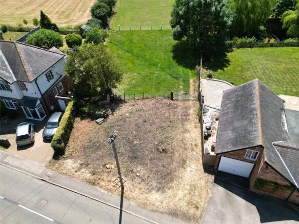
Plot
- SIZE
Ask agent
Key features
- Single Self Build or Custom Build Plot
- Ideal Development Opportunity
- Outline Planning Permission
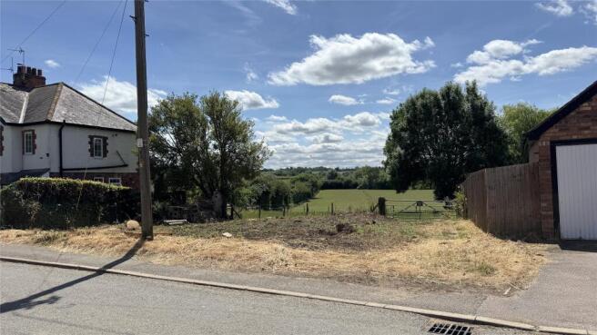
- Fabulous Plot of Approximately 0.25 acres
- Central Village Position
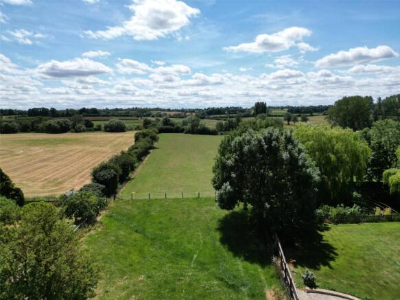
- Enviable Countryside Views to the Rear
- Permission for a Two Storey Detached Dwelling with Garage
- Associated Parking with In & Out Driveway
- Services Located in Front of the Site
Description
Location
Gaddesby is a particularly unspoilt and popular village convenient for commuting to the surrounding centres of Melton Mowbray, Loughborough and Leicester. The village offers local primary school, popular pub, and church with nearby Syston and Melton Mowbray offering a further range of local facilities and amenities. The centre piece of the village is Gaddesby Hall and the village is particularly leafy and unspoilt with many attractive cottages and houses.
Planning Permission
Planning permission was passed on 7 March 2025 by Melton Borough Council with outline planning permission subject to reserved matters. Planning reference with Melton Borough Council 24/00510/OUT. Outline permission has been granted for a single dwelling with all matters reserved including change of use of existing agricultural land. There are nine conditions associated with the grant of out line planning permission. One of the conditions is that the development shall not be constructed other than as a self-build or custom build dwelling as defined under the Self-build and Custom Housebuilding Act 2015 (as amended by the Housing and Planning Act 2016) and shall not be used for any other purpose without express planning permission.
Services & Miscellaneous
It is our understanding that all mains services including gas, electric, water and drainage are located on Ashby Road in front of the site.
Situation
The plot is located in the attractive village of Gaddesby which is set in rural Leicestershire approximately seven miles from the market town of Melton Mowbray which has shopping facilities. Gaddesby village is situated approximately 13 miles to the south-west of Leicester city centre where there are extensive business and leisure facilities. The Rutland towns of Uppingham and Oakham are located to the south-east of the village with the A47 connecting Leicester with Peterborough. Gaddesby is also within good proximity to Leicester Train Station where there are direct rail links to London St Pancras Station in just over an hours travel. The village has good access links to the East Midlands extensive road network including the A1, M1 A40, M69 and M6. Within the village there is a local village primary school which currently has Ofsted ‘Outstanding’ status with a further choice of excellent schooling within the region.
Viewing
All enquiries relating to the plot and for viewings please contact Melissa Hopson at Bentons or
Extra Information
To check Internet and Mobile Availability please use the following link: checker.ofcom.org.uk/en-gb/broadband-coverage To check Flood Risk please use the following link: check-long-term-flood-risk.service.gov.uk/postcode
Brochures
ParticularsAshby Road, Gaddesby, Leicester

NEAREST STATIONS
Distances are straight line measurements from the centre of the postcode- Syston Station4.4 miles
- Melton Mowbray Station5.4 miles

About Bentons, Melton Mowbray
47 Nottingham Street Melton Mowbray Leicestershire, LE13 1NN
Notes
Disclaimer - Property reference BNT250653. The information displayed about this property comprises a property advertisement. Rightmove.co.uk makes no warranty as to the accuracy or completeness of the advertisement or any linked or associated information, and Rightmove has no control over the content. This property advertisement does not constitute property particulars. The information is provided and maintained by Bentons, Melton Mowbray. Please contact the selling agent or developer directly to obtain any information which may be available under the terms of The Energy Performance of Buildings (Certificates and Inspections) (England and Wales) Regulations 2007 or the Home Report if in relation to a residential property in Scotland.
Map data ©OpenStreetMap contributors.