
Over Compton, Sherborne, Dorset

- PROPERTY TYPE
Plot
- SIZE
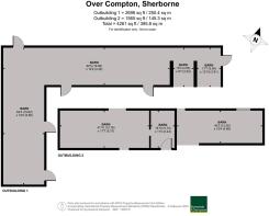
4,694 sq ft
436 sq m
Key features
- Granted planning permission for three barn conversions
- Beautiful, rural setting bordering open countryside
- Close proximity Sherbornes' amenities
Description
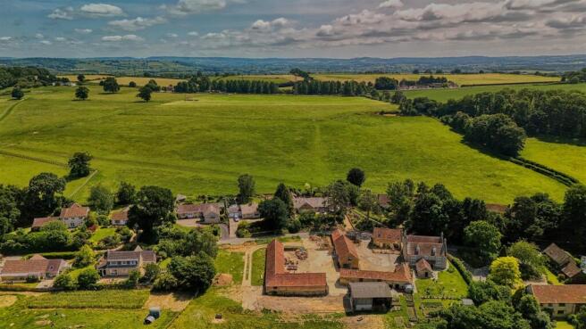
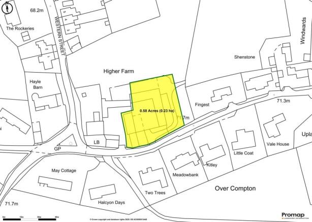
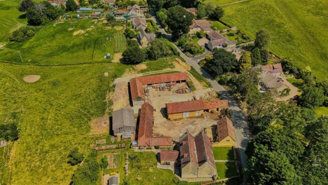
The Property - Set in a beautiful, rural position and yet not far from good road links, this development site of 0.58 acres (0.23 hectares) includes two existing agricultural barns.
Accommodation - Planning permission has been granted under reference P/FUL/2022/03668 for the change of use of three barns. The proposed scheme will create three attractive single storey dwellings, comprising one detached property and a pair of semi-detached barns. Each home will benefit from private gardens and allocated parking.
Set in a picturesque rural location, the development will enjoy far-reaching views across open countryside towards Trent, offering a peaceful and characterful setting with excellent potential.
Full details and documents relating to both permissions are available via the Planning Portal on Dorset Council -
Situation - Set equidistant between Sherborne and Yeovil, the charming village of Over Compton is nestled in the heart of the Dorset countryside. This picturesque location offers a peaceful rural setting while remaining conveniently close to amenities. The neighbouring village of Trent provides a highly regarded pub and a well-regarded primary school, adding to the area's appeal.
The neighbouring historic Abbey town of Sherborne, offers a range of independent shops, restaurants and supermarkets. The area is well-served by excellent schooling, including The Gryphon School, as well as prestigious independent schools such as Sherborne School, Sherborne Girls, Leweston, and Hazlegrove. For commuters, a direct train from Sherborne to London Waterloo takes approximately 2.5 hours, while Castle Cary, just 12 miles away, offers a faster 90-minute service to Paddington. Bournemouth, Bristol, and Exeter airports are also within easy reach, providing excellent transport connections.
Material Information - Broadband - Superfast broadband is available.
Mobile phone network coverage is likely inside on most major networks, connection available inside on some networks.
(Information from Ofcom
Dorset Council
The barns are located within the curtilage of Higher Farmhouse which is Grade II Listed.
Directions - What3words - ///class.shout.having
Viewing Arrangements - All viewings to be accompanied by agent or vendor, please contact the agent to book a suitable time and date.
Agents Note - Several more modern barns on the site have already been demolished. In addition, part of a barn located to the north, outside the area being offered for sale, remains to be demolished and rebuilt, which will be undertaken at the seller’s expense.
A shared right of way will be required to allow both the seller and the buyer access for building and maintenance purposes in a designated area.
The seller will retain a right of way for vehicles, including for occasional cattle movements, over the access route leading to their retained land.
Brochures
Details Higher Farm Building Plot.pdfOver Compton, Sherborne, Dorset

NEAREST STATIONS
Distances are straight line measurements from the centre of the postcode- Yeovil Pen Mill Station1.3 miles
- Yeovil Junction Station2.1 miles
- Thornford Station2.7 miles

About Symonds & Sampson, Sherborne
4 Abbey Corner Half Moon Street, Sherborne, DT9 3LN


Notes
Disclaimer - Property reference 34008023. The information displayed about this property comprises a property advertisement. Rightmove.co.uk makes no warranty as to the accuracy or completeness of the advertisement or any linked or associated information, and Rightmove has no control over the content. This property advertisement does not constitute property particulars. The information is provided and maintained by Symonds & Sampson, Sherborne. Please contact the selling agent or developer directly to obtain any information which may be available under the terms of The Energy Performance of Buildings (Certificates and Inspections) (England and Wales) Regulations 2007 or the Home Report if in relation to a residential property in Scotland.
Map data ©OpenStreetMap contributors.