
Land East of Higher Shaftesbury Road, Blandford Forum
- PROPERTY TYPE
Land
- SIZE
1,628,273 sq ft
151,272 sq m

Key features
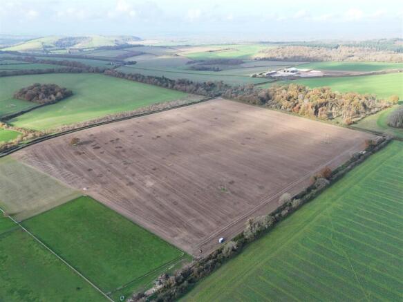
- A useful block extending to 37.38 acres
- Good highway access
- Mains water connected
- Far reaching views of the Blackmore Vale
- Situated within the Cranborne Chase National Landscape
- Suitable for a variety of uses subject to consent
Description
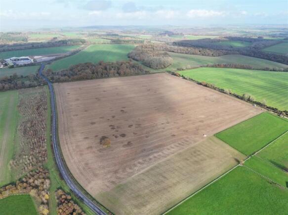
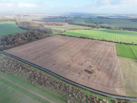
The Property - A good sized block of productive, level to gently sloping and west-facing arable land extending to 37.38 acres (15.13 hectares). Boundaries are predominantly comprised of well-established hedgerows with a number of mature trees and areas of stock proof fencing. The land benefits from good access off the adjoining unclassified highway in the northwestern and northeastern corners.
The soil is freely draining slightly acid loam over chalk. The entirety is classified as Grade 3 on the ALC map. The land has been part of an arable rotation for a number of years and generates healthy yields.
Situation - The land is situated in an elevated position 4 miles to the north of the market town of Blandford Forum. The A350 which connects Blandford Forum and Shaftesbury, adjoins the western boundary of the land. Lying between 110m & 135m above sea level, the land boasts impressive westerly views of the wider rural landscape.
Designations - The land is situated in the Cranborne Chase National Landscape (formerly AONB) and in a groundwater Nitrate Vulnerable Zone. No public rights of way pass through the property.
Agricultural Schemes - The land is not entered into any agricultural or environmental schemes.
Services - There is a submetred mains water supply located in the southeastern corner of the land.
Mains electricty passess through the land on a north to south trajectory, no connection has been made.
Agents Notes - There is a gas main which passes through the field on an east to west trajectory, the route of the main is shown via gas marker posts on the eastern and western boundaries.
With reference to points A & B on the sale plan, the vendor will erect a stockproof fence within 1 month of completion.
Tenure & Possesion - Freehold title with vacant possession on completion.
All mineral and sporting rights are included within the sale.
Local Authority - Dorset Council -
What3words - ///barn.protected.overnight
Viewing - Unaccompanied viewings during daylight hours with a set of sales particulars in hand after informing the agents. Contact Will Wallis on or Will Cairns on .
Wayleaves, Easements & Rights Of Way - The property is sold subject to and with the benefit of all rights including; rights of way, whether public or private, light, support, drainage, water and electricity supplies and other rights and obligations, easements and quasieasements and restrictive covenants and all existing and proposed wayleaves for masts, pylons, stays, cables, drains, water and gas and other pipes whether referred to in these particulars or not.
Informal Tender - The land is for sale by Informal Tender with offers to be received by the 17th December 2025 at 12 noon.
The tender form is available upon request from the vendor's sole agents, Symonds & Sampson. Contact Will Wallis on or Will Cairns on .
Brochures
Sales Particulars.pdfLand East of Higher Shaftesbury Road, Blandford Forum

NEAREST STATIONS
Distances are straight line measurements from the centre of the postcode- Gillingham (Dorset) Station10.1 miles

About Symonds & Sampson, Dorchester
9 Weymouth Avenue Brewery Square, Dorchester DT1 1QR


Notes
Disclaimer - Property reference 34305510. The information displayed about this property comprises a property advertisement. Rightmove.co.uk makes no warranty as to the accuracy or completeness of the advertisement or any linked or associated information, and Rightmove has no control over the content. This property advertisement does not constitute property particulars. The information is provided and maintained by Symonds & Sampson, Dorchester. Please contact the selling agent or developer directly to obtain any information which may be available under the terms of The Energy Performance of Buildings (Certificates and Inspections) (England and Wales) Regulations 2007 or the Home Report if in relation to a residential property in Scotland.
Map data ©OpenStreetMap contributors.