
Down Thomas, South Hams
- PROPERTY TYPE
Land
- SIZE
167,270 sq ft
15,540 sq m
Key features
- For sale by Formal Tender with a deadline date for tenders being Thursday 15th January 2026 at 12 noon
- Situated in the picturesque village of Down Thomas
- Offering potential for a variety of other uses to include equine, amenity/recreation (subject to planning)
- Long term development potential (subject to planning)
- Natural perimeter hedges
- Approximately 3.84 acres (1.55 hectares) in all of permanent pasture
Description
DIRECTIONS
From Staddiscombe, take Bovisand Lane towards Wembury. At Rack Corner junction, turn right towards Down Thomas/Bovisand/Heybrook Bay. After 0.8 miles, the land access is on the right.
What3Words Location:- modem.trend.richer
SITUATION
The land is situated within the village of Down Thomas, in the South hams area of South Devon and within an Area Designated as National Landscape (formerly known as the AONB).
The city of Plymouth is approximately 5.6 miles to the northwest. The A38 dual carriageway expressway, connecting to the M5 motorway and national road network, being about 5.6 miles to the northeast with direct access via Deep Lane junction.
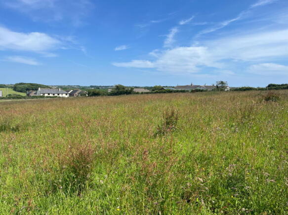
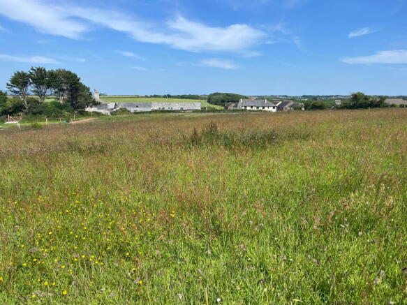
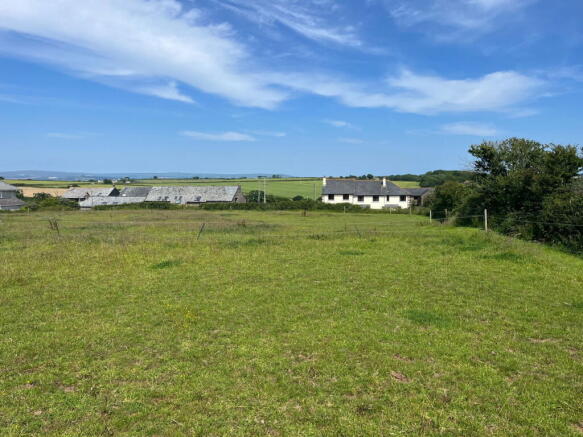
DESCRIPTION
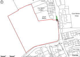
The land to the west of Renney Road extends to approximately 3.84 acres (1.55 hectares) of permanent pasture land in all as outlined in red on the site plan.
Predominantly of a level south facing gradient, enclosed by natural perimeter hedgerows on all boundaries. The land has wide stretching views across the surrounding coastal landscape.
The land is bordered by adjoining agricultural land to the north and west, residential properties and the council maintained highways - Renney Road to the east and Manor Bourne Road to the south.
The land is currently down to grass having been cut to silage and grazed by cattle in the past and most recently grazed by horses. The land offers the potential for a variety of uses, to include general recreation/amenity/ equine or other uses, subject to obtaining the necessary planning consents.
Please note that photographs were taken in July 2025.
ACCESS
Access to the land is via a right of way over a third party owned ramp off the council maintained highway which leads to the single vehicular width gateway, as highlighted in green and marked by the letter ‘G’ on the site plan below.
TENURE
The property is being offered for sale on a freehold basis with vacant possession available on completion.
SERVICES
There are no services connected to the land.
PUBLIC RIGHTS OF WAY
There are no public footpaths or rights of way as far as known.
WAYLEAVES AND EASEMENTS
The land is sold subject to any Wayleave and Easements agreements.
ENVIRONMENTAL STEWARDSHIP
The land is not subject to any Environmental or Countryside Stewardship Scheme agreements.
SPORTING RIGHTS AND MINERAL RIGHTS
All sporting and mineral rights are included in the sale, as far as are known.
METHOD OF SALE
The land is being offered for sale by Formal Tender (unless sold prior). The deadline date for the submission of tenders Thursday 15th January 2026 at 12 noon and all tenders must be submitted to 62 Fore Street, Kingsbridge in an envelope clearly marked ‘Land to the west of Renney Road’.
Buyers who wish to submit a tender will be required to sign a legal contract, available from the solicitor acting for the seller and provide a deposit equivalent to 10% of their offer price as their tender. Please be advised that any tender offer that is unsuccessful will have their 10% deposit returned.
If either of these two component parts are not submitted, their tender risks being declined.
Moreover, the successful purchaser will be liable to pay the sum of £2,000 + VAT as an administration fee in addition to their tender.
A tender which is accepted by the seller will be treated as a binding contract and immediately constitutes an exchange of contracts.
Legal completion and payment of the balance of the purchase price will follow approximately 28 days later, or in the time frame as set out in the legal pack.
The seller does not undertake to accept the highest or any of the offers and the seller reserves the right to withdraw, alter or amend the way in which the land is offered for sale.
TENDER PACK
A copy of the tender pack may be requested from the seller's solicitors, Bartons Solicitors of 20 Fore Street, Kingsbridge, TQ7 1NZ Attention: Roseanna McNally, Tel: e-mail:
Prospective purchasers are advised to seek their own legal advice on the tender pack.
OVERAGE CLAUSE
An overage clause will apply in relation to the sale of this land for a period of 25 years such that 25% of the uplift in value will be paid to the sellers (or their successors in title) in the event that planning consent is gained for change of use to residential. Further detail on the overage deed and a copy of this is provided in the Legal Pack.
GUIDE PRICE
£95,000
HEALTH & SAFETY
Any prospective purchasers of whom would like to view the land do so at their own risk. The vendors nor their selling agent accept any responsibility in any incident or accident that may happen.
VIEWING
Strictly by appointment with the Sole Agents, Luscombe Maye of 62 Fore Street, Kingsbridge TQ7 1PP Telephone for details.
Brochures
Brochure 1Down Thomas, South Hams

NEAREST STATIONS
Distances are straight line measurements from the centre of the postcode- Plymouth Station3.6 miles
- Devonport Station4.3 miles
- Dockyard Station4.7 miles

Notes
Disclaimer - Property reference S1507547. The information displayed about this property comprises a property advertisement. Rightmove.co.uk makes no warranty as to the accuracy or completeness of the advertisement or any linked or associated information, and Rightmove has no control over the content. This property advertisement does not constitute property particulars. The information is provided and maintained by Luscombe Maye Farms & Land, Kingsbridge. Please contact the selling agent or developer directly to obtain any information which may be available under the terms of The Energy Performance of Buildings (Certificates and Inspections) (England and Wales) Regulations 2007 or the Home Report if in relation to a residential property in Scotland.
Map data ©OpenStreetMap contributors.