
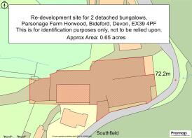
Horwood, Bideford
- PROPERTY TYPE
Land
- SIZE
28,314 sq ft
2,630 sq m
Key features
- Freehold re-development site
- PP to build 2 open market bungalows
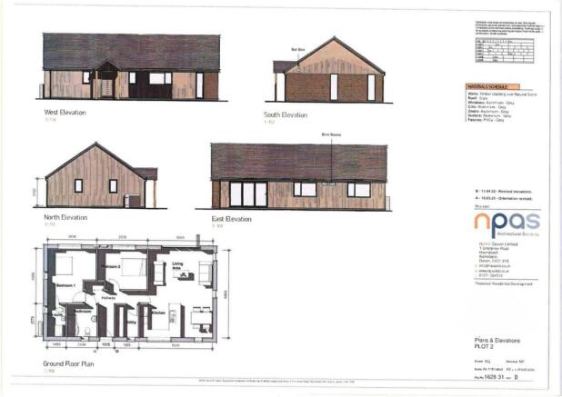
- 3 Beds, 2 Bath, Open Plan Rec/Kitchen
- 2 Beds, 2 Bahs, Open plan Rec/Kitchen
- Parking and Gardens for each
- 156 sq m [1681 sq ft] & 88 sq m [950 sq ft]
- Site about 0.65 acres.
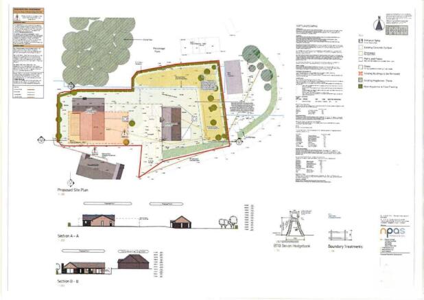
- Potential for separate access points
- Mains electricity & water nearby
- Priced to sell!
Description
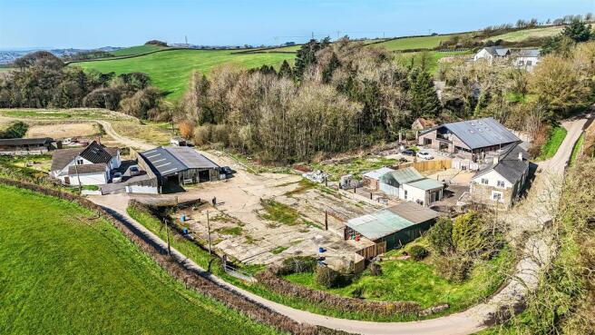
Situation And Amenities - Parsonage Farm lies on the fringe of the village of Horwood in glorious rural surroundings yet is within easy reach of various towns and the North Devon Coastline. Horwood boasts an ancient Church. Other amenities nearby include Lovacott Primary School about 1 mile, and the Hunters Inn and restaurant at Newton Tracey, about 2 miles. The historic port town Bideford is about 4 miles and offers a range of every day amenities including supermarkets, pubs, restaurants and leisure facilities. Just 4 ½ miles away is the popular coastal and estuary village of Instow with sandy beach and access to the Tarka Trail. The Regional Centre of Barnstaple, is about 6 miles north east and houses the area’s main business, leisure and shopping venues as well as District Hospital. At Barnstaple there is access to the North Devon Link Road which runs on in about 45 minutes or so to Junction 27 of the M5 Motorway and where Tiverton Parkway offers a fast service of trains to London Paddington in just over 2 hours. The nearest International Airports can be found at either Bristol or Exeter.
Services - Mains electricity and water [currently metered] are available nearby. It is envisaged that a private drainage system/s will need to be installed.
Local Authority - North Devon District Council. Telephone: (
Viewing - Please contact Stags to arrange a viewing appointment. Tel: . Email:
Directions - At Roundswell roundabout take the first exit on the B3232 towards Torrington and continue for approximately 2.7 miles. Once you reach the outskirts of Newton Tracey take the first right sign posted Lovacott/Horwood. Continue for approximately 1.5 miles. Just before the Church bear left signed posted Ashridge/Torrington follow the lane and the farm is about 1/3rd of a mile.
Disclaimer - These particulars are a guide only and are not to be relied upon for any purpose.
Description/Planning - Full planning permission was achieved on 17th June, 2025 for 'Demolition of rural building and erection of two dwellings and associated works [fall back position following approval 79017] (departure)' All relevant documentation can be viewed via the North Devon Council website, Planning Section, using the latest planning reference; 79706 for access. The two dwellings proposed are both bungalows. The proposed elevations and layouts are shown in the plans accompanying these particulars.
This former farmyard will eventually comprise 5 detached dwellings, 3 of which are already established, each with independent access points. The planning consent for the two proposed bungalows currently shows an access which is initially shared however, there may be scope to totally separate these, subject to planning permission.
Brochures
Horwood, BidefordHorwood, Bideford

NEAREST STATIONS
Distances are straight line measurements from the centre of the postcode- Barnstaple Station4.6 miles
- Chapleton Station5.0 miles


Notes
Disclaimer - Property reference 34577756. The information displayed about this property comprises a property advertisement. Rightmove.co.uk makes no warranty as to the accuracy or completeness of the advertisement or any linked or associated information, and Rightmove has no control over the content. This property advertisement does not constitute property particulars. The information is provided and maintained by Stags, Barnstaple. Please contact the selling agent or developer directly to obtain any information which may be available under the terms of The Energy Performance of Buildings (Certificates and Inspections) (England and Wales) Regulations 2007 or the Home Report if in relation to a residential property in Scotland.