
Wrangaton, South Brent
- PROPERTY TYPE
Land
- SIZE
323,215 sq ft
30,028 sq m
Key features
- Approximately 7.42 acres (2.99 hectares) in all
- For sale as a whole or in up to two lots (4.26 acres & 3.16 acres)
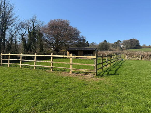
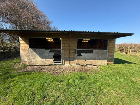
- Timber frame field shelter (24.50 sq. metres)
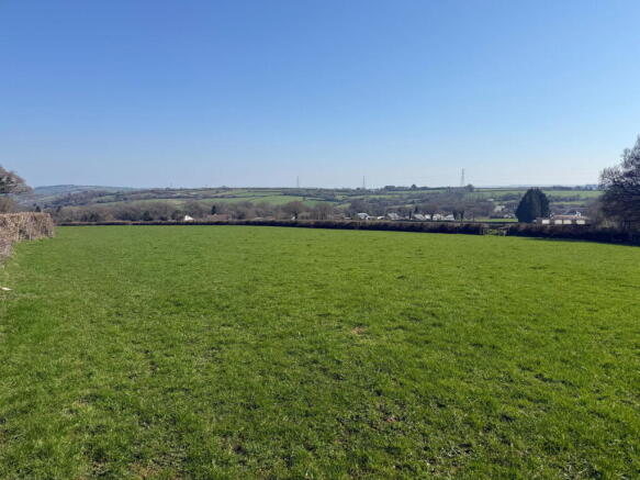
- Level permanent pasture
- Mains water supply
- Good road access
- Potential for a range of uses such as recreation, amenity, or equestrian purposes (subject to planning)
- Excellent riding out facilities onto Dartmoor
- For sale by Formal Tender with a closing date of Thursday 4th June at 12 noon
Description
DIRECTIONS
From South Brent, head west on Exeter Road towards Plymouth and turn right signposted “Brent Mill Business Park, Glazebrook & Aish.” Continue for approximately 0.5 miles, then keep right onto Cheston Lane. After about 1 mile, the gate to Lot 1 is on the left.
Take an immediate left and after approx. 100 yards, the wooden gate to Lot 2 is on the left.
What3Words (Lot 1) – emphasis.reboot.mailers
What3Words (Lot 2) – supposes.recorders.stolen
SITUATION
The land is situated on the outskirts of the village of Wrangaton, in the South Hams area of South Devon and within the Dartmoor National Park.
The nearby market town of Ivybridge is approximately 3.5 miles distant, and the village of South Brent is approximately 2 miles away. Access to Dartmoor is just 0.5 miles distant, while the A38 dual carriageway expressway, connecting to the M5 motorway and national road network, is approximately 0.7 miles.
DESCRIPTION
Land at Marwoods Cross comprises approximately 7.42 acres (2.99 hectares) in all, the full extent of which is outlined in red on the site plan.
The land is currently used for livestock grazing and equestrian purposes but would be very suitable for a variety of uses including recreation/ amenity, or alternative uses, subject to obtaining the necessary planning consents.
LOT 1 (as shaded blue on the site plan)
Extending in all to approximately 4.26 acres (1.72 hectares) of permanent pastureland, as shaded blue on the site plan.
The land is of a level gradient and is bound by stock proof fencing and mature Devon hedge banks. Lot 1 benefits from mains water, supplying a water trough in the south western corner of the field.
Accessed via a single vehicular width wooden gateway in the western corner of the land off the council-maintained highway (Wrangaton Road) marked with the letter ‘G’ on the site plan.
LOT 2 (as shaded yellow on the site plan)
Extending to approximately 3.16 acres (1.27 hectares) of permanent pasture, as shaded yellow on the site plan. Gently sloping east-facing land, enclosed by mature Devon hedge banks and stock-proof fencing.
The field parcel benefits from a field shelter measuring approximately [7m x 3.50m] equating to 24.50 square metres. The structure is of timber frame under a corrugated bitumen roof with rubber matting floor and stone beneath.
Surrounding the field shelter is a small paddock area enclosed by timber post and rail fencing. The area has a hardcore base, which continues from the entrance gateway around the entire enclosed paddock.
Lot 2 benefits from a water trough in close proximity to the field shelter which comes off the Lot 1 water meter. See water supply paragraph below.
Access to the land can be gained through the single vehicular width wooden gateway on the south western boundary, marked with the letter ‘G’ on the site plan.
Subject to weather conditions and the grass growth the vendor reserves the right to take a cut of the grass prior to the completion date.
WATER SUPPLY
In the event that the land sells in separate
lots, the buyer of Lot 2 will undertake to install a submeter to supply the existing water trough in Lot 2 within 8 weeks following legal completion. The buyer of Lot 1 will be required to read the submeter and issue an invoice on a quarterly basis to Lot 2 at South West Waters prevailing rate.
Alternatively, if Lot 2 does not require this mains water supply, the connection will be disconnected by Lot 1 within 8 weeks following completion.
BOUNDARY OWNERSHIP BETWEEN THE LOTS
In the event that the land sells in separate lots, the buyer of Lot 2 will erect a standard agricultural stock proof fence within 8 weeks of legal completion along the boundary between the two lots, marked by the A-B on the site plan. This boundary will become a party boundary whereby each Lot will maintain their own side.
PUBLIC RIGHTS OF WAY
There are no public rights of way over the land as far as known.
TENURE
The land is being offered on a freehold basis with vacant possession being available on legal completion.
SPORTING AND MINERAL RIGHTS
The sporting and mineral rights are included in the sale, as far as are known.
ENVIRONMENTAL STEWARDSHIP
The land is not subject to any Environmental or Countryside Stewardship agreements.
WAYLEAVES AND EASEMENTS
The land is sold subject to any Wayleave and Easements agreements.
GUIDE PRICES
Lot 1 - £50,000
Lot 2 - £60,000
The Whole - £110,000
METHOD OF SALE
The land at Marwoods Cross is offered for sale by Formal Tender (unless sold prior). The deadline date for the submission of tenders is Thursday 4th June 2026 at 12 noon, and all tenders must be submitted to 62 Fore Street, Kingsbridge in a sealed envelope clearly marked ‘Land at Marwoods Cross’.
Buyers who wish to submit a tender will be required to complete and sign the tender form and provide any supporting documentation as detailed within the Legal Pack available from the solicitor acting for the seller (see Legal Pack below).
Any tender received by the deadline date will be subject to contract. Prospective purchasers should be aware that upon acceptance of their tender offer, a 10% deposit of the agreed sale price will be payable to the agent acting for the seller, within 24 hours of written acceptance of their offer. Failure to do so within this time frame will result in the tender being rejected.
Should a tender be acceptable to the seller and the 10% deposit received, this will then constitute exchange of contracts and legal completion including payment of the balance of the purchase price will follow approximately 28 days later or by the time frame set out in the Legal Pack.
If the deposit is failed to be presented by the successful tender, then the Formal Tender Conditions will not be met, and this will result in the tender being rejected.
The successful purchasers of each lot will also be liable to pay the sum of £2,500 plus VAT as an administration fee in addition to their tender should their tender be acceptable to the seller. In the event the land is sold as a whole (both lots to one purchaser), the administration fee will be £3,750 plus VAT.
Please note, the seller does not undertake to accept the highest or any of the offers and the seller reserves the right to withdraw, alter or amend the way in which the land is offered for sale.
LEGAL PACK
A copy of the legal pack may be requested from the seller's solicitors, Howard & Over Solicitors of Plym House, 3 Longbridge Road, Plymouth, PL6 8LT.
Attention: Jacob Cunningham
Tel:
E-mail: jacob.
LOCAL AUTHORITY
Ward - South Hams District Council, Follaton House, Plymouth Road, Totnes, Devon, TQ9 5NE. Tel: .
Planning authority - Dartmoor National Park Authority, Parke, Bovey Tracey, Newton Abbot, Devon TQ13 9JQ Tel:
HEALTH & SAFETY
Any prospective purchasers of whom would like to view the land do so at their own risk. The vendors nor their selling agent accept any responsibility in any incident or accident that may happen.
VIEWING
Strictly by appointment with the Sole Agents, Luscombe Maye of 62 Fore Street, Kingsbridge, TQ7 1PP. Telephone for details.
Brochures
Brochure 1Wrangaton, South Brent

NEAREST STATIONS
Distances are straight line measurements from the centre of the postcode- Ivybridge Station2.2 miles

Notes
Disclaimer - Property reference S1700167. The information displayed about this property comprises a property advertisement. Rightmove.co.uk makes no warranty as to the accuracy or completeness of the advertisement or any linked or associated information, and Rightmove has no control over the content. This property advertisement does not constitute property particulars. The information is provided and maintained by Luscombe Maye Farms & Land, Kingsbridge. Please contact the selling agent or developer directly to obtain any information which may be available under the terms of The Energy Performance of Buildings (Certificates and Inspections) (England and Wales) Regulations 2007 or the Home Report if in relation to a residential property in Scotland.
Map data ©OpenStreetMap contributors.