

Frampton
- PROPERTY TYPE
Land
- SIZE
764,478 sq ft
71,022 sq m
Key features
- 17.55 acres in total
- 15.08 acres of pastureland split into two parcels
- 2.47 acres of attractive, shelterbelt woodland
- Stock fenced and productive
- Private water supply
- Peaceful rural location with attractive views
Description
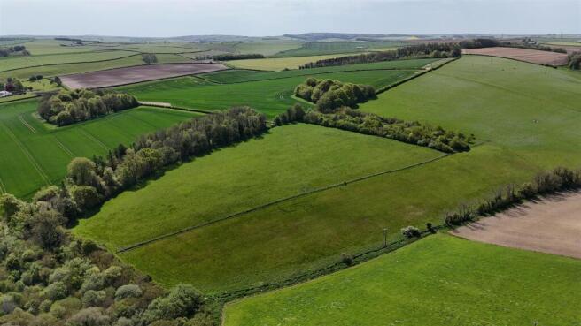
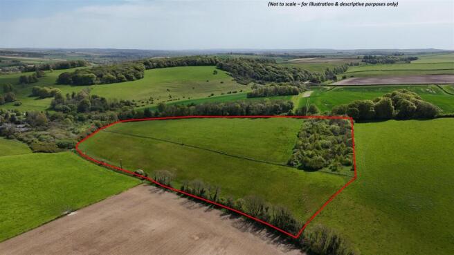
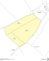
The Land - The land extends to a total of 17.55 acres (7.10 hectares), comprising 15.08 acres (6.10 hectares) of pastureland split into two parcels and 2.47 acres (1.00 hectare) of attractive, mixed species shelterbelt woodland.
The pastureland is level to sloping, stock fenced to all sides and suitable for either grazing or cutting and features stream frontage to the north. All of the land is Grade 3 on the Agricultural Land Classification maps.
The woodland features a mix of species and benefits from being deer fenced. The woodland acts as a useful and attractive shelter belt providing relief to the rest of the land from prevailing south westerly winds.
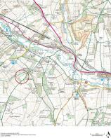
Situation - The land is set in a peaceful rural location, situated just over 4 miles northwest of the County Town of Dorchester which provides an excellent range of amenities and facilities. More locally, the village of Maiden Newton, just less than 3 miles to the northwest features a petrol station with spa shop, railway station and GP Surgery.
The A37 is approximately 1 mile to the northeast of the land and provides good communication links to Dorchester and Yeovil. The A35 is approximately 1 mile to the south, providing a good communication link between Dorchester and Bridport.
Directions - From Dorchester, take the A37 towards Yeovil, travelling west through the village of Grimstone, then turning left towards Frampton. After approximately 350m, turn left through the entrance to Frampton Park featuring stone pillars, continue over the bridge, along the concrete track, bearing right at the crest of hill. Take the next left signposted “Metlands” and “Steppes Farm”. Continue past Littlewood Farm on your left-hand side and Metlands on your right after approximately 450m. Continue past the cattle grid into Steppes Farm on your right whilst bearing left and continue uphill to the entrance located approximately at What3Words location ///sapping.explain.boom.
Access - Access is over third-party owned land from the A356 as described above. The access is for all times and all purposes with the exception of any access in connection with the establishment, use or operation of any commercial leisure or tourism use. Please see the legal pack for more details to include maintenance responsibilities.
Tenure & Possession - Freehold with vacant possession upon completion.
Services - Private water supply restricted to 1,850m³ per year, imposed by a previous transfer of the land containing the source of the water. A submeter will be installed by the vendor at location shown X on the plan before completion. See the legal pack for more details.
Public Rights Of Way - A public bridleway crosses the land, following the southeastern boundary.
Environmental Schemes - The pastureland is currently entered into a Mid-Tier Countryside Stewardship Agreement, however, its cancellation has been requested. The purchaser will not be obligated to continue the scheme or be liable for any penalties or repayments. See the legal pack for more details.
The woodland is subject to an obligation period following it planting, funded by a farm Woodland Premium Scheme Agreement. See the legal pack for more details.
None of the land is subject to any Sustainable Farming Incentive Agreements.
Rights, Easements & Boundaries - The land is sold subject to and with the benefit of all rights including rights of way whether public or private, light, support, drainage, water and electricity supplies and other rights and obligations, easements and quasi-easements and restrictive covenants and all existing and proposed wayleaves or masts, pylons, stays, cables, drains and water, gas or other pipes whether referred to in the particulars of sale and legal pack.
Designations - All of the land lies within the Dorset National Landscape (previously Area of Outstanding Natural Beauty) and within a Nitrate Vulnerable Zone (NVZ).
Local Authority - Dorset Council, telephone number:
Agent's Notes - A grave is present on the land, contained within a small stock fenced enclosure at location marked Y on the plan. The grave will be present in perpetuity. See the legal pack for more details.
What3words - ///inspects.obstinate.conspire
Solicitors - Burges Salmon Solicitors
Peter Roberts - Peter. /
Brochures
Final Particulars - Land at Frampton Park.pdfFrampton

NEAREST STATIONS
Distances are straight line measurements from the centre of the postcode- Maiden Newton Station2.9 miles
- Dorchester West Station4.4 miles
- Dorchester South Station4.6 miles

About Symonds & Sampson, Dorchester
9 Weymouth Avenue Brewery Square, Dorchester DT1 1QR


Notes
Disclaimer - Property reference 34716458. The information displayed about this property comprises a property advertisement. Rightmove.co.uk makes no warranty as to the accuracy or completeness of the advertisement or any linked or associated information, and Rightmove has no control over the content. This property advertisement does not constitute property particulars. The information is provided and maintained by Symonds & Sampson, Dorchester. Please contact the selling agent or developer directly to obtain any information which may be available under the terms of The Energy Performance of Buildings (Certificates and Inspections) (England and Wales) Regulations 2007 or the Home Report if in relation to a residential property in Scotland.
Auction Fees: The purchase of this property may include associated fees not listed here, as it is to be sold via auction. To find out more about the fees associated with this property please call Symonds & Sampson, Dorchester on 01305 232500.
*Guide Price: An indication of a seller's minimum expectation at auction and given as a “Guide Price” or a range of “Guide Prices”. This is not necessarily the figure a property will sell for and is subject to change prior to the auction.
Reserve Price: Each auction property will be subject to a “Reserve Price” below which the property cannot be sold at auction. Normally the “Reserve Price” will be set within the range of “Guide Prices” or no more than 10% above a single “Guide Price.”