Land on the North Side of Paul Street

- PROPERTY TYPE
Commercial Property
- SIZE
Ask agent
Key features
- 2 Street frontages, Paul Street and Blackstock Street
- Planning permission for 310 residential units (19F/2446), with documents in the data room
- Offered with vacant possession
- Approximate site area of 1.15 acres
- Freehold interest
Description
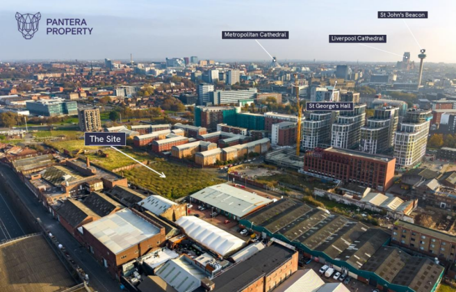
A freehold development site in the Vauxhall area, on the northern edge of Liverpool city centre, extending to approximately 1.15 acres (0.47 hectares) with frontages to both Paul Street and Blackstock Street.
Planning permission was granted under application 19F/2446 for a residential block of up to ten storeys containing 310 units. It is offered for sale with vacant possession, and buyers will be expected to satisfy themselves on planning, title and ground conditions.
A data room containing title documents, planning documents andavailable drawings is available to seriously interested parties on request.
No warranty is given as to the accuracy or completeness of third-party reports
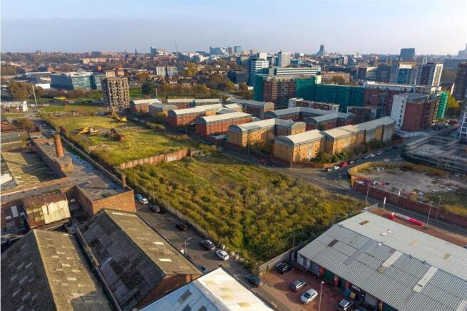
The Site - Cleared land with two street frontages.
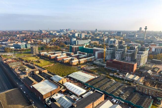
The site is a broadly level, broadly rectangular parcel of cleared land of approximately 1.15 acres (0.47 hectares), with a frontage to Paul Street on the south side and to Blackstock Street on the north. It adjoins garages and commercial units to the west and open land to the east. We understand piling works have been carried out on the site. Their extent, specification and condition have not been verified and no reliance can be placed on them. Buyers should carry out their own technical investigations
Residential Planning Permission - The site lies within the area covered by the Liverpool Local Plan 2013–2033. Planning permission has been granted on land at Blackstock Street/Paul Street, which we understand includes the site, as follows:
19F/2446 - “To erect part 10, part 8, part 7 storey residential block containing 310 units consisting of 146 1 bed units and 156 no 2 bed units, with associated access, servicing, parking and landscaping.”
Granted subject to conditions. Decision notice issued by Liverpool City Council on 8 March 2023
Buyers must make their own enquiries of Liverpool City Council on the status of thepermission, including whether it has been lawfully implemented, and on conditions, planning obligations, Community Infrastructure Levy and biodiversity net gain
Tenure - Freehold, registered at HM Land Registry under title numbers MS682582, MS682583, MS682584 and MS682585. Sale extent as shown on the site plan.
Location - The site lies in the Vauxhall area of Liverpool, a short distance north of the city centre's commercial core. It lies between Paul Street to the south and Blackstock Street to the north, close to the junction with St Bartholomew Road and just north of Leeds Street.
The surrounding area mixes established commercial and workshop premises with residential development, including the Atlantic Point apartments directly to the south. Several residential schemes have been proposed or approved nearby
in recent years, including consent for 416 apartments off Blackstock Street in 2024.
Moorfields, Liverpool Lime Street and Sandhills stations are all within reach. Lime Street provides intercity services, and Moorfields and Sandhills serve the Merseyrail network.
Technical And Sale Terms - Services
We are not aware of any services currently connected. Buyers must make their own enquiries of the statutory undertakers on availability, capacity and connection costs.
Method of sale
The site is offered for sale by private treaty.
VAT
All figures are quoted exclusive of VAT, which may be chargeable.
Legal costs
Each party is to be responsible for their own legal costs incurred in the transaction
Viewing
Strictly by appointment with the selling agents. The site must not be entered without an appointment.
Planning and technical
Buyers should rely on their own enquiries of the council and their own ground, title and technical due diligence.
Brochures
Paul Street Liverpool - Land Brochure.pdfLand on the North Side of Paul Street

NEAREST STATIONS
Distances are straight line measurements from the centre of the postcode- Moorfields Station0.4 miles
- James Street Station0.7 miles
- Liverpool Lime Street Station0.7 miles
Notes
Disclaimer - Property reference 35048468. The information displayed about this property comprises a property advertisement. Rightmove.co.uk makes no warranty as to the accuracy or completeness of the advertisement or any linked or associated information, and Rightmove has no control over the content. This property advertisement does not constitute property particulars. The information is provided and maintained by Pantera Property, Harrogate. Please contact the selling agent or developer directly to obtain any information which may be available under the terms of The Energy Performance of Buildings (Certificates and Inspections) (England and Wales) Regulations 2007 or the Home Report if in relation to a residential property in Scotland.