
Oxford Road, Horspath, Oxford, Oxfordshire, OX33
- PROPERTY TYPE
Land
- SIZE
Ask agent
Key features
- Village development plot with permission in principle
- Edge of village site in close proximity to Oxford
- For sale by informal tender.
Description
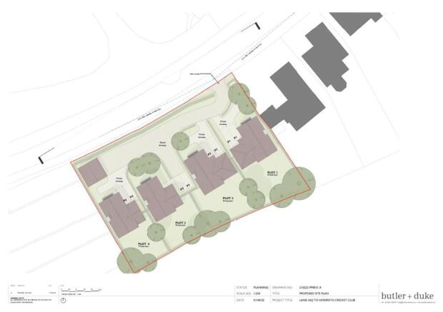
DEVELOPMENT SITE WITH PERMISSION IN PRINCIPLE FOR 4 DWELLINGS ON THE EDGE OF THE POPULAR VILLAGE OF HORSPATH, OXFORDSHIRE.
LOCATION
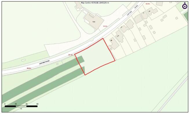
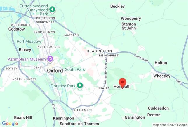
The property is situated on the eastern edge of Horspath, a popular village on the outskirts of Oxford. The property fronts directly onto the Oxford Road and is located opposite Horspath Village Hall.
The ancient village of Horspath, inhabited long before 1066, lies on the slopes of Shotover, just 1.5 miles from the Oxford ring road and approximately 4 miles from the City Centre. Junction 8 of the M40 is close by at Wheatley providing access into London. The village offers both a Pre-School Nursery and a Primary School, the St Giles Parish Church, Horspath, Oxford Brewery, The Queens Head, The Gurkha Palace Restaurant/ Chequers Inn and a variety of clubs and societies. The Hub – the village’s community meeting hall – hosts regular activities including exercise classes, a film club, and an outreach post office every Friday.
THE PROPERTY
The property extends to approximately 0.65 acres (0.26 hectares) and comprises a grassed field bounded by hedges on all sides. The topography of the property is broadly level.
PLANNING AND PROPOSED DEVELOPMENT
The local planning authority is South Oxfordshire District Council.
The property benefits from a permission in principle for residential development comprising a minimum of 1 and a maximum of 4 dwellings in accordance with the terms of the application Ref P25/S1133/PIP. Planning Practice Guidance (PPG) advises that this is an alternative way of obtaining planning permission for housing-led development. The permission in principle consent route has 2 stages: the first stage (or permission in principle stage) establishes whether a site is suitable in-principle and the second (‘technical details consent’) stage is when the detailed development proposals are assessed. This permission in principle has been granted at appeal and relates to the first of these 2 stages. Further details can be found on the Appeal Decision. The proposed site plan and proposed site elevation have been classed by the Appeal Inspector as being for illustrative purposes only. This applies to all imagery contained within our marketing.
REGISTERED TITLE
The property is registered with the Land Registry under three titles:
ON106523
ON234001
ON270501
FURTHER INFORMATION
An information pack has been prepared to accompany these particulars and contains all the relevant planning, technical and illustrative drawings.
METHOD OF SALE
The opportunity is offered for sale freehold
with vacant possession by informal tender.
Offers should be received by email in
accordance with the Bidding Guidance
contained in the Information Pack and
marked “Land at Horspath Tender”. A date for bids to be received by will be provided in due course.
VIEWING
The property may be viewed from the highway.
Parties wishing to walk the site should arrange
an appointment with Carter Jonas.
Brochures
ParticularsOxford Road, Horspath, Oxford, Oxfordshire, OX33

NEAREST STATIONS
Distances are straight line measurements from the centre of the postcode- Oxford Station4.2 miles
- Radley Station4.5 miles
- Oxford Parkway Station6.3 miles


Notes
Disclaimer - Property reference OXF260066. The information displayed about this property comprises a property advertisement. Rightmove.co.uk makes no warranty as to the accuracy or completeness of the advertisement or any linked or associated information, and Rightmove has no control over the content. This property advertisement does not constitute property particulars. The information is provided and maintained by Carter Jonas, Oxford. Please contact the selling agent or developer directly to obtain any information which may be available under the terms of The Energy Performance of Buildings (Certificates and Inspections) (England and Wales) Regulations 2007 or the Home Report if in relation to a residential property in Scotland.